Badakhshan is a historical region comprising parts of modern-day north-eastern Afghanistan, eastern Tajikistan, and Taxkorgan Tajik Autonomous County in China. Badakhshan Province is one of the 34 provinces of Afghanistan. Much of historic Badakhshan lies within Tajikistan's Gorno-Badakhshan Autonomous Region, in the southeastern part of the country. The music of Badakhshan is an important part of the region's cultural heritage.

Badakhshan Province is one of the 34 provinces of Afghanistan, located in the northeastern part of the country. It is bordered by Tajikistan's Gorno-Badakhshan in the north and the Pakistani regions of Lower and Upper Chitral and Gilgit-Baltistan in the southeast. It also has a 91-kilometer (57-mile) border with China in the east.

Jurm District is one of the 28 districts of Badakhshan province in northeast Afghanistan. The district capital is a town named Jurm. The district is 3 hours from the center of the province in Fayzabad, and is home to approximately 41,910 residents. The highest point of the Afghan Hindu Kush is located in Jurm District, at 6729 meters. The district consist of clusters and villages. Ferghamenj, Kyb, Kyteb, Ularyb, Ferghameru, Khustak, and Iskan are the clusters. Each cluster contain villages; the district is largely Tajik speaking.

Argo District is one of the 28 districts in Badakhshan province, Afghanistan. It was created in 2005 from part of Fayzabad District and is home to approximately 45,000 residents.

Darayim is a district in Badakhshan province, Afghanistan. It was created in 2005 from part of Fayzabad District and is home to an estimated 68,419 residents.

Tagab is one of the 29 districts of Badakhshan province in Afghanistan. It was created in 2005 from part of Fayzabad District and has a population of approximately 31,207 residents. The Karaste Canal is located in Tagab District.

Yaftal Sufla is one of the 29 districts of Badakhshan province in eastern Afghanistan. It was created in 2005 from part of the Fayzabad District and is home to approximately 58,626 residents.

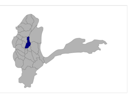
Baharak district is a district of Badakhshan province, Afghanistan located about 30 km southeast of Fayzabad. The capital is the city of Baharak. The district is also called Baharistan.
Fayzabad Airport is located about 3.5 miles (5.6 km) northwest of Fayzabad, the capital of Badakhshan Province in Afghanistan. It is a domestic airport under the country's Ministry of Transport and Civil Aviation (MoTCA), and serves the population of Badakhshan Province. Security in and around the airport is provided by the Afghan National Security Forces.
Fayzabad District may refer to:

Fayzabad District is one of 30 districts that comprise Badakhshan province, Afghanistan. The city of Fayzabad serves as its capital. In 2005, several portions of the district were sub-divided to create several new districts within the province. The remaining portion is home to approximately 75,577 residents, who are mostly peasants.

Kalafgan District is a district of Takhar Province, Afghanistan. The district is well governed, with self-governance in parts of Kalafgan because of how remote they are. 42 villages are located in the district. In 2017, Kalafgan was considered to be under full control by the Afghan Government. However, the Taliban had taken full control by August 2021.
Basenj also known as Basinj is a village in Badakhshan Province in north-eastern Afghanistan.

Ishkashim is a border town in Badakhshan Province of Afghanistan. With a population of around 12,120 people, the town serves as the capital of Ishkashim District. Another town by the same name is located on the other side of the Panj River in the Gorno-Badakhshan region of Tajikistan, although that town is normally transliterated Ishkoshim following Tajik practice. A bridge linking the two towns was reconstructed in 2006.
Kakan is a village in Badakhshan Province in north-eastern Afghanistan. It lies on the northern part of the Kokcha River, roughly 25 miles northeast of Fayzabad.

Fayzabad is a city in northeastern Afghanistan, with a population of around 39,555 people. It serves as the provincial capital and largest city of Badakhshan Province. It is situated in Fayzabad District and is at an altitude of 1,254 metres (4,114 ft).
On March 4, 2012, at least three avalanches struck the Badakhshan province of northeastern Afghanistan. One of those avalanches destroyed a small village of about 200 people. The name of the village is uncertain; some sources call it Dasty and locate it in Darzab District, and others call it Sherin Nazim and locate it in Shekay District. Two other villages were affected by the avalanche. At least 50 people were killed in the disaster.
This is a list of the extreme points of Afghanistan.