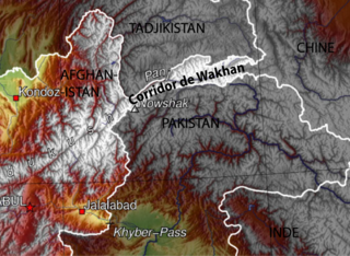
The Wakhan Corridor is a narrow strip of territory in the Badakhshan province of Afghanistan. This corridor stretches eastward, connecting Afghanistan to Xinjiang, China. It also separates the Gorno-Badakhshan Autonomous Region of Tajikistan in the north from the Khyber Pakhtunkhwa and Gilgit-Baltistan regions of Pakistan in the south, the latter of which is also part of the disputed region of Kashmir. This high mountain valley, which rises to a maximum altitude of 4,923 m (16,152 ft), serves as the source of both the Panj and Pamir rivers, which converge to form the larger Amu Darya River. For countless centuries, a vital trade route has traversed this valley, facilitating the movement of travelers to and from East, South, and Central Asia.
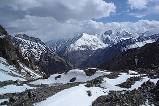
The Pamir Mountains are a range of mountains between Central Asia and South Asia. They are located at a junction with other notable mountains, namely the Tian Shan, Karakoram, Kunlun, Hindu Kush and the Himalaya mountain ranges. They are among the world's highest mountains.
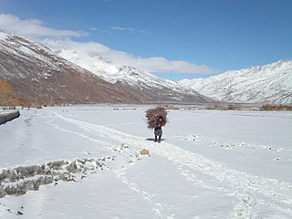
Wakhan, or "the Wakhan", is a rugged, mountainous part of the Pamir, Hindu Kush and Karakoram regions of Afghanistan. Wakhan District is a district in Badakshan Province.

The Panj, traditionally known as the Ochus River and also known as Pyandzh (derived from its Slavic word, is a river in Afghanistan and Tajikistan and is a tributary of the Amu Darya. The river is 921 kilometres long and has a basin area of 114,000 square kilometres. It forms a considerable part of the Afghanistan–Tajikistan border.

The Pamir River is a shared river located in the Badakhshan Province of Afghanistan and in the Gorno-Badakhshan in Tajikistan. It is a tributary of the Panj River, and forms the northern boundary of Afghanistan's Wakhan District.

The Bartang is a river of Central Asia, and is a tributary to the Panj which itself is a tributary to the Amu Darya. In its upper reaches, it is also known as the Murghab and Aksu; it flows through the Wakhan in Afghanistan, then through the Rushon District of the Gorno-Badakhshan autonomous region, Tajikistan. The river is 528 kilometres (328 mi) long and has a basin area of 24,700 square kilometres (9,500 sq mi).
Amurn is a village in Darwaz District, Badakhshan Province in north-eastern Afghanistan.

Arakht is a village in Badakhshan Province in north-eastern Afghanistan.
Ashnam is a village in Badakhshan Province in north-eastern Afghanistan.

Ishkashim is a border town in Badakhshan Province of Afghanistan, which has a population of around 12,120 people. The town serves as the capital of Ishkashim District. Another town by the same name is located on the other side of the Panj River in the Gorno-Badakhshan region of Tajikistan, although that town is normally transliterated Ishkoshim following Tajik practice. A bridge linking the two towns was reconstructed in 2006.
Fotur is a village on the left bank of the Ab-i-Panj river in Badakhshan Province in north-eastern Afghanistan.
Kushgag is a village in Badakhshan Province in north-eastern Afghanistan.
Mina Do is a village in Badakhshan Province in northeast Afghanistan.
Mina Vad is a village in Badakhshan Province in north-eastern Afghanistan.
Qalʽeh-ye Panjeh, also written Qila-e Panjeh and Kala Panja, is a village in Wakhan, Badakhshan Province in north-eastern Afghanistan. It lies on the Panj River, near the confluence of the Wakhan River and the Pamir River.

The Wakhjir Pass, also spelled Vakhjir Pass, is a mountain pass in the Hindu Kush or Pamirs at the eastern end of the Wakhan Corridor, the only potentially navigable pass between Afghanistan and China in the modern era. It links Wakhan in Afghanistan with the Tashkurgan Tajik Autonomous County in Xinjiang, China, at an altitude of 4,923 metres (16,152 ft). The pass is not an official border crossing point. With a difference of 3.5 hours, the Afghanistan–China border has the sharpest official change of clocks of any international frontier. China refers to the pass as South Wakhjir Pass, as there is a northern pass on the Chinese side.

The Little Pamir is a broad U-shaped grassy valley or pamir in the eastern part of the Wakhan in north-eastern Afghanistan. The valley is 100 km long and 10 km wide, and is bounded to the north by the Nicholas Range, a subrange of the Pamir Mountains.
The Afghanistan–China border is a 92-kilometre-long (57 mi) boundary between Afghanistan and China, beginning at the tripoint of both countries with the Pakistan's federally administered territory of Gilgit-Baltistan, following the watershed along the Mustagh Range, and ending at the tripoint with Tajikistan. This short border is in the far northeast of Afghanistan, distant from much of the country or urban areas in either country, at the end of the long, narrow Wakhan Corridor. The Chinese side of the border is in the Chalachigu Valley. The border is crossed by several mountain passes, including Wakhjir Pass in the south and Tegermansu Pass in the north.
Karachukar Valley or Chalachigu Valley is a valley in Taxkorgan Tajik Autonomous County, Xinjiang, China. It contains the basin of the Karachukar River, a tributary of the Tashkurgan River, and is regarded as part of Taghdumbash Pamir. The valley borders Afghanistan to the west and northwest, Tajikistan to the north, and Pakistan to the south. The name of the valley is from Kyrgyz, meaning "black cave".
The Afghanistan–Tajikistan border is 1,357 km (843 mi) in length and runs from the tripoint with Uzbekistan in the west to the tripoint with the Xinjiang region of China in the east, almost entirely along the Amu Darya, Pyanj and Pamir Rivers, except for the easternmost section along the Wakhan Corridor and divides the ethnic Tajik community into citizens of two separate countries.

