
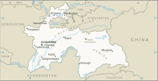
Tajikistan, officially the Republic of Tajikistan, is a mountainous, landlocked country in Central Asia with an area of 143,100 km2 (55,300 sq mi) and an estimated population of 9,537,645 people. It is bordered by Afghanistan to the south, Uzbekistan to the west, Kyrgyzstan to the north and China to the east. The traditional homelands of the Tajik people include present-day Tajikistan as well as parts of Afghanistan and Uzbekistan.

Tajiks are a Persian-speaking Iranian ethnic group native to Afghanistan, Tajikistan, and Uzbekistan. Tajiks are the largest ethnicity in Tajikistan, and the second largest in Afghanistan which constitutes over half of the global Tajik population. They speak varieties of Persian, a Western Iranian language. In Tajikistan, since the 1939 Soviet census, its small Pamiri and Yaghnobi ethnic groups are included as Tajiks. In China, the term is used to refer to its Pamiri ethnic groups, the Tajiks of Xinjiang, who speak the Eastern Iranian Pamiri languages. In Afghanistan, the Pamiris are counted as a separate ethnic group.

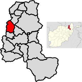
Kunduz or Qunduz is one of the 34 provinces of Afghanistan, located in the northern part of the country next to Tajikistan. The population of the province is around 953,800, which is mostly a tribal society; it is one of Afghanistan's most ethnically diverse provinces with many different ethnicities in large numbers living there. The city of Kunduz serves as the capital of the province. It borders the provinces of Takhar, Baghlan, Samangan and Balkh. The Kunduz Airport is located next to the provincial capital.
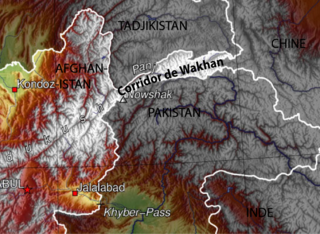
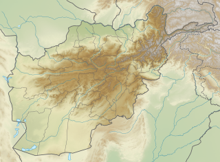
The Wakhan Corridor is a narrow strip of territory in Afghanistan, extending to China and separating Tajikistan from Pakistan and Kashmir. The corridor, wedged between the Pamir Mountains to the north and the Karakoram range to the south, is about 350 km (220 mi) long and 13–65 kilometres (8–40 mi) wide. From this high mountain valley the Panj and Pamir Rivers emerge and form the Amu Darya. A trade route through the valley has been used by travellers going to and from East, South and Central Asia since antiquity.

Kulob, also Kulyab, is a city in Kulob District, Khatlon Province, Tajikistan. Located 203 km south-east of the capital Dushanbe on the Yakhsu River, it is one of the largest cities in the country and has an estimated population of 100,000. The town is served by Kulob Airport.

The Kuhistani Badakhshan Autonomous Region is an autonomous region in Eastern Tajikistan. Located in the Pamir Mountains, it makes up 45% of the land area of the country but only 3% of its population.
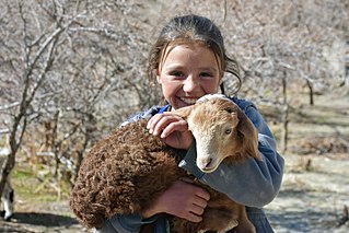
The Wakhi people or the Khik (خیک), are an Iranian ethnic group living in adjacent, remote regions of Afghanistan, Tajikistan, Pakistan and China. They are predominantly centered in Afghanistan's Wakhan Corridor, the northern-most part of Pakistan's Gilgit-Baltistan, the Gorno-Badakhshan region of Tajikistan and the southwestern region of China's Xinjiang. They are native speakers of Wakhi, an Indo-European language of the Iranian branch.

Dorah Pass, also called Durah Pass, connects Badakshan Province of Afghanistan with Chitral District in Khyber Pakhtunkhwa, Pakistan. The Dorah Pass is more than 14,000 feet (4,300 m) high. It is located along the Durand Line border and crosses the Hindu Kush mountain range. Situated at the foot of the pass is Lake Dufferin, also known locally as Hawz-i Dorah. The lake is roughly 2 3⁄4 miles (4.4 km) long by over one-quarter mile (0.4 km) broad.

Khwahan /(Tajik: Хоҳон) is the name of a district, a fort and a town in Badakhshan Province in north-eastern Afghanistan. They are all located on the left bank of the Panj River, sub-regions of Darwaz.
Khwaja Ghar District is a district of Takhar Province, Afghanistan. The district was badly destroyed during the 1996-2001 Afghan Civil War in fighting between the Taliban and the Northern Alliance.
Yangi Qala District is a district in Takhar Province, Afghanistan. Economically the population of this district is primarily involved in agriculture. The main crops are rice and wheat, and the surplus rice is exporting to neighboring districts and provinces. On September 10, 2019, the district was taken the Taliban. 3 days later, the district was of militants cleared in an operation. There are 64 villages in the district.
An earthquake occurred in northern Afghanistan on 30 May 1998, at 06:22 UTC in the Takhar Province with a moment magnitude of 6.5 and a maximum Mercalli intensity of VII. At the time, the Afghan Civil War was underway; the affected area was controlled by the United Islamic Front for the Salvation of Afghanistan.

Arakht is a village in Badakhshan Province in north-eastern Afghanistan.
Ghar Javin is the name of a mountain pass and of a nearby village in Badakhshan Province in north-eastern Afghanistan. The valley contains three villages of the same time. Nearby is the direct road from Bar Panja, located some miles downstream, and Badakhshan. The village is located about four miles north of the pass.
Langar is a village in the Wakhan District, Badakhshan Province in north-eastern Afghanistan. It lies on the Panj River, opposite the larger village of Langar in Tajikistan.
Parya is a Central Indo-Aryan language spoken in parts of Afghanistan, Uzbekistan and Tajikistan especially on Dushanbe city. Tajuzbeki was an alternative name coined by Bholanath Tiwari for the same language. Much of the academic research in documenting and characterizing this isolated Indo-Aryan language was done by prominent Soviet linguist I. M. Oranski.

The Tajik–Afghan bridge at Tem-Demogan was opened on 3 November 2002. It spans the Panj River. It was the first of four bridges planned to be built with the assistance of the Aga Khan Foundation.
This page shows the Tajikistan national football team's results in International Matches, as recognized by FIFA:

The Tajikistan Insurgency was a military conflict which took place in eastern Tajikistan between the Tajik Army and Islamist militants, led by numerous leaders from the Tajikistani Civil War. The conflict evolved in 2010 and climaxes in 2012, with the defeat of main rebel forces. Other incidents took place in September 2015, when former deputy defense minister Abduhalim Nazarzoda led an armed uprising, suspected with ties to the Islamic Renaissance Party.
The China–Tajikistan border is 477 km (296 mi) in length and runs from the tripoint with Kyrgyzstan following a roughly north-south line across various mountain ridges and peaks of the Pamir range down to the tripoint with Afghanistan. The border divides Murghob District, Gorno-Badakhshan Autonomous Region in Tajikistan from Akto County, Kizilsu Kyrgyz Autonomous Prefecture and Taxkorgan Tajik Autonomous County, Kashgar Prefecture in Xinjiang Uygur Autonomous Region, China.

