The Amu Darya is a major river in Central Asia and Afghanistan. Rising in the Pamir Mountains, north of the Hindu Kush, the Amu Darya is formed by the confluence of the Vakhsh and Panj rivers, in the Tigrovaya Balka Nature Reserve on the border between Afghanistan and Tajikistan, and flows from there north-westwards into the southern remnants of the Aral Sea. In its upper course, the river forms part of Afghanistan's northern border with Tajikistan, Uzbekistan, and Turkmenistan. In ancient history, the river was regarded as the boundary of Greater Iran with "Turan", which roughly corresponded to present-day Central Asia. The Amu Darya has a flow of about 70 cubic kilometres per year on average.
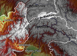
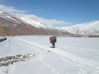
The Wakhan Corridor is a narrow strip of territory in Badakhshan Province of Afghanistan, extending to Xinjiang in China and separating the Gorno-Badakhshan Autonomous Region of Tajikistan in the north from the northern areas of Pakistan in the south. From this high mountain valley the Panj and Pamir rivers emerge and form the bigger Amu River. A trade route through the valley has been used by travellers going to and from East, South and Central Asia since antiquity.

Wakhi is an Indo-European language in the Eastern Iranian branch of the language family spoken today in Wakhan District, Northern Afghanistan and also in Tajikistan, Northern Pakistan and China.
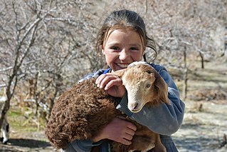
The Wakhi people, also locally referred to as the Wokhik, are an Iranian ethnic group native to Central and South Asia. They are found in Afghanistan, Tajikistan, Pakistan and China—primarily situated in and around Afghanistan's Wakhan Corridor, the northernmost part of Pakistan's Gilgit−Baltistan and Chitral, Tajikistan's Gorno−Badakhshan Autonomous Region and the southwestern areas of China's Xinjiang Uyghur Autonomous Region. The Wakhi people are native speakers of the Wakhi language, an Eastern Iranian language.

The Panj, traditionally known as the Ochus River and also known as Pyandzh, is a tributary of the Amu Darya. The river is 921 kilometres (572 mi) long and has a basin area of 114,000 square kilometres (44,000 sq mi). It forms a considerable part of the Afghanistan–Tajikistan border.
Ab Gaj is a village in Badakhshan Province in north-eastern Afghanistan. It is on the left bank of the Ab-i-Wakhan about a mile upstream of the meeting of that river and the Amu Darya, and about ten miles southeast of Kala Panja.
Deh Gholaman is a village in Badakhshan Province in north-eastern Afghanistan on the Wakhan River, roughly 20 miles west of Baroghil.

Ishkashim is a border town in Badakhshan Province of Afghanistan. With a population of around 12,120 people, the town serves as the capital of Ishkashim District. Another town by the same name is located on the other side of the Panj River in the Gorno-Badakhshan region of Tajikistan, although that town is normally transliterated Ishkoshim following Tajik practice. A bridge linking the two towns was reconstructed in 2006.
Fotur is a village on the left bank of the Ab-i-Panj river in Badakhshan Province in north-eastern Afghanistan.
Khandud (Khandut) is a village in Badakhshan Province in north-eastern Afghanistan. It is in Wakhan District, near the left bank of the Panj River.
Langar is a village in the Wakhan District of Badakhshan Province, in north-eastern Afghanistan. It lies on the river Panj, opposite the larger village of Toqakhona in Tajikistan.
Qalʽeh-ye Panjeh, also written Qila-e Panjeh and Kala Panja, is a village in Wakhan, Badakhshan Province in north-eastern Afghanistan. It lies on the Panj River, near the confluence of the Wakhan River and the Pamir River.
Qazi Deh is a village in Badakhshan Province in north-eastern Afghanistan. It lies on the left bank of the Panj River, 20 km from Ishkashim.

Sarhadd or Sarhad, also known as Sarhad-e Broghil or Sarhad-e Wakhan, is a village in the Wakhan District of Badakhshan Province, Afghanistan.

Wakhan River ; known locally as Ab-i-Wakhan or Abe Vâxân, Вахондарё and Vaxondaryo) is the name of the Sarhadd branch of the Panj River along its upper length in the Wakhan District of Badakhshan Province of Afghanistan.

The Wakhjir Pass, also spelled Vakhjir Pass, is a mountain pass in the Hindu Kush or Pamirs at the eastern end of the Wakhan Corridor, the only potentially navigable pass between Afghanistan and China in the modern era. It links Wakhan in Afghanistan with the Tashkurgan Tajik Autonomous County in Xinjiang, China, at an altitude of 4,923 metres (16,152 ft), but the pass is not an official border crossing point. With a difference of 3.5 hours, the Afghanistan–China border has the sharpest official change of clocks of any international frontier. China refers to the pass as South Wakhjir Pass, as there is a northern pass on the Chinese side.

The Little Pamir is a broad U-shaped grassy valley or pamir in the eastern part of the Wakhan in north-eastern Afghanistan. The valley is 100 km long and 10 km wide, and is bounded to the north by the Nicholas Range, a subrange of the Pamir Mountains.
The Great Pamir or Big Pamir is a broad U-shaped grassy valley or pamir in the eastern part of the Wakhan in north-eastern Afghanistan and the adjacent part of Tajikistan, in the Pamir Mountains. Zorkol lake lies at the northern edge of the Great Pamir.

The Afghanistan–Tajikistan border is 1,357 km (843 mi) in length and runs from the tripoint with Uzbekistan in the west to the tripoint with China in the east, almost entirely along the Amu Darya, Pyanj and Pamir rivers, except for the easternmost section along the Wakhan Corridor.