
Brunei is a country in Southeast Asia, bordering the South China Sea and East Malaysia. Its geographical coordinates are 4°30′N114°40′E. The country is small with a total size of 5,765 km2 (2,226 sq mi). It is larger in size than Trinidad and Tobago. It is close to vital sea lanes through the South China Sea linking the Indian and Pacific Oceans. The country has two parts physically separated by Malaysia, making it almost an enclave within Malaysia.

Burkina Faso is a landlocked Sahel country that shares borders with six nations. It lies between the Sahara desert and the Gulf of Guinea, south of the loop of the Niger River, mostly between latitudes 9° and 15°N, and longitudes 6°W and 3°E. The land is green in the south, with forests and fruit trees, and semi-arid in the north. Most of central Burkina Faso lies on a savanna plateau, 198–305 metres (650–1,001 ft) above sea level, with fields, brush, and scattered trees. Burkina Faso's game preserves – the most important of which are Arly, Nazinga, and W National Park—contain lions, elephants, hippopotamus, monkeys, common warthogs, and antelopes. Previously the endangered painted hunting dog, Lycaon pictus occurred in Burkina Faso, but, although the last sightings were made in Arli National Park, the species is considered extirpated from Burkina Faso.
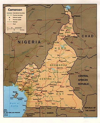
At 475,440 km2 (183,570 sq mi), Cameroon is the world's 53rd largest country. It is slightly larger than the nation of Sweden and the US state of California. It is comparable in size to Papua New Guinea. Cameroon's landmass is 472,710 km2 (182,510 sq mi), with 2,730 km2 (1,050 sq mi) of water.

Ivory Coast is a sub-Saharan nation in southern West Africa located at 8 00°N, 5 00°W. The country is approximately square in shape. Its southern border is a 515 km (320 mi) coastline on the Gulf of Guinea on the north Atlantic Ocean. On the other three sides it borders five other African nations for a total of 3,458 km (2,149 mi): Liberia to the southwest for 778 km (483 mi), Guinea to the northwest for 816 km (507 mi), Mali to the north-northwest for 599 km (372 mi), Burkina Faso to the north-northeast for 545 km (339 mi), and Ghana to the east for 720 km (447 mi).
Kazakhstan is located in Central Asia. With an area of about 2,724,900 square kilometers (1,052,100 sq mi) Kazakhstan is more than twice the combined size of the other four Central Asian states and 60% larger than Alaska. The country borders Turkmenistan, Uzbekistan, and Kyrgyzstan to the south; Russia to the north; Russia and the Caspian Sea to the west; and China's Xinjiang Uygur Autonomous Region to the east.

Lithuania is a country in the Baltic region of Europe. The most populous of the Baltic states, Lithuania has 262 km (163 mi) of coastline consisting of the continental coast and the "Curonian Spit" coast. Lithuania's major warm-water port of Klaipėda (Memel) lies at the narrow mouth of Curonian Lagoon, a shallow lagoon extending south to Kaliningrad and separated from the Baltic sea by Curonian Spit, where Kuršių Nerija National Park was established for its remarkable sand dunes.

Sierra Leone is a country in West Africa with a North Atlantic Ocean coastline to the west. It lies on the African Plate. The island's main geographical features include wooded hill country, an upland plateau, and mountains in the east. The highest peak is Mount Bintumani, which is 1,948 meters (6,391 ft) above sea level. The coastline has a belt of mangrove swamps. Freetown, the nation's capital city, has one of the world's largest natural harbours. The Rokel River is the largest river in Sierra Leone. It is 400 kilometres (250 mi) long and has a basin with a total area of 10,622 square kilometres (4,101 sq mi).
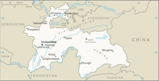
Tajikistan is nestled between Kyrgyzstan and Uzbekistan to the north and west, China to the east, and Afghanistan to the south. Mountains cover 93 percent of Tajikistan's surface area. The two principal ranges, the Pamir Mountains and the Alay Mountains, give rise to many glacier-fed streams and rivers, which have been used to irrigate farmlands since ancient times. Central Asia's other major mountain range, the Tian Shan, skirts northern Tajikistan. Mountainous terrain separates Tajikistan's two population centers, which are in the lowlands of the southern and northern sections of the country. Especially in areas of intensive agricultural and industrial activity, the Soviet Union's natural resource utilization policies left independent Tajikistan with a legacy of environmental problems.
Turkmenistan is a landlocked country in Central Asia, bordering the Caspian Sea to the west, Iran and Afghanistan to the south, Uzbekistan to the north-east, and Kazakhstan to the north-west. It is the southernmost republic of the Commonwealth of Independent States (CIS), the loose federation created at the end of 1991 by most of the Post-Soviet states.

Yemen is located in Southwest Asia, at the southern tip of the Arabian Peninsula, between Oman and Saudi Arabia. It is situated at the entrance to the Bab-el-Mandeb Strait, which links the Red Sea to the Indian Ocean and is one of the most active and strategic shipping lanes in the world. Yemen has an area of 527,970 square kilometres (203,850 sq mi), including the islands of Perim at the southern end of the Red Sea and Socotra at the entrance to the Gulf of Aden. Yemen's land boundaries total 1,746 kilometres (1,085 mi). Yemen borders Saudi Arabia to the north and Oman to the northeast. Through the Socotra island, Yemen also shares borders with the Guardafui Channel and the Somali Sea.

Malawi is a landlocked country in southeast Africa. It is wholly within the tropics; from about 9°30S at its northernmost point to about 17°S at the southernmost tip. The country occupies a thin strip of land between Zambia and Mozambique, extending southwards into Mozambique along the valley of the Shire River. In the north and north east it also shares a border with Tanzania. Malawi is connected by rail to the Mozambican ports of Nacala and Beira. It lies between latitudes 9° and 18°S, and longitudes 32° and 36°E.

Geographically, the country of Iran is located in West Asia and borders the Caspian Sea, Persian Gulf, and Gulf of Oman. Topographically, it is predominantly located on the Persian Plateau. Its mountains have impacted both the political and the economic history of the country for several centuries. The mountains enclose several broad basins, on which major agricultural and urban settlements are located. Until the 20th century, when major highways and railroads were constructed through the mountains to connect the population centers, these basins tended to be relatively isolated from one another.
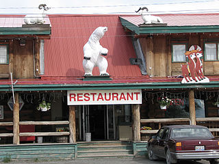
Beaver Creek is a community in Yukon, Canada. Located at kilometre 1870.6 of the Alaska Highway, 1 NM southeast of Beaver Creek Airport and close to the Alcan - Beaver Creek Border Crossing, it is Canada's westernmost community. The community's main employers are a Canada Border Services Agency port, the White River First Nation and a number of tourist lodges.
Khōst is the capital of Khost Province in Afghanistan. It is the largest city in the southeastern part of the country, and also the largest in the region of Loya Paktia. To the south and east of Khost lie Waziristan and Kurram in Pakistan. Khost is the home of Shaikh Zayed University. Khost Airport serves the city as well as the larger region surrounding the city.
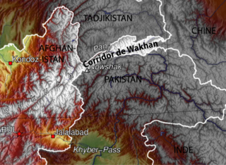
The Wakhan Corridor is a narrow strip of territory in Badakhshan Province of Afghanistan, extending to Xinjiang in China and separating the Gorno-Badakhshan Autonomous Region of Tajikistan from the Gilgit-Baltistan region of Pakistan-administered Kashmir. From this high mountain valley the Panj and Pamir rivers emerge and form the bigger Amu River. A trade route through the valley has been used by travellers going to and from East, South and Central Asia since antiquity.

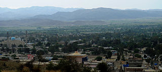
Maymana is the capital city of Faryab Province in northwestern Afghanistan, near the Turkmenistan border. It is approximately 400 km (250 mi) northwest of the country's capital Kabul, and is located on the Maymana River, which is a tributary of the Murghab River. The population of Maymana was 149,040 in 2015, making it one of the largest cities of northwestern Afghanistan.
This article lists extreme locations on Earth that hold geographical records or are otherwise known for their geophysical or meteorological superlatives. All of these locations are Earth-wide extremes; extremes of individual continents or countries are not listed.
The Rural Municipality of Ritchot is a rural municipality in the Winnipeg Capital Region, bordering the south side of Winnipeg in Manitoba, Canada. The separately-administered town of Niverville lies adjacent to its southeast, between it and the Rural Municipality of Hanover.

Climate of Peru describes the diverse climates of this large South American country with an area of 1,285,216 km2 (496,225 sq mi). Peru is located entirely in the tropics but features desert and mountain climates as well as tropical rainforests. Elevations above sea level in the country range from −37 to 6,778 m and precipitation ranges from less than 20 mm (0.79 in) annually to more than 8,000 mm (310 in). There are three main climatic regions: the Pacific Ocean coast is one of the driest deserts in the world but with some unique features; the high Andes mountains have a variety of microclimates depending on elevation and exposure and with temperatures and precipitation from temperate to polar and wet to dry; and the Amazon basin has tropical climates, mostly with abundant precipitation, along with sub-tropical climates in elevations above 1,550 m (5,090 ft).

Mouthe is a commune in the Doubs department in the Bourgogne-Franche-Comté region in eastern France. The town is known for having the coldest recorded temperature in France.


