
The Geography of Pakistan is a profound blend of landscapes varying from plains to deserts, forests, and plateaus ranging from the coastal areas of the Arabian Sea in the south to the mountains of the Karakoram, Hindukush, Himalayas ranges in the north. Pakistan geologically overlaps both with the Indian and the Eurasian tectonic plates where its Sindh and Punjab provinces lie on the north-western corner of the Indian plate while Balochistan and most of the Khyber Pakhtunkhwa lie within the Eurasian plate which mainly comprises the Iranian Plateau. Gilgit-Baltistan and Azad Kashmir lie along the edge of the Indian plate and are prone to violent earthquakes where the two tectonic plates collide.

Geographically, Iran is located in West Asia and borders the Caspian Sea, Persian Gulf, and Gulf of Oman. Its mountains have helped to shape both the political and the economic history of the country for several centuries. The mountains enclose several broad basins, on which major agricultural and urban settlements are located. Until the 20th century, when major highways and railroads were constructed through the mountains to connect the population centers, these basins tended to be relatively isolated from one another.
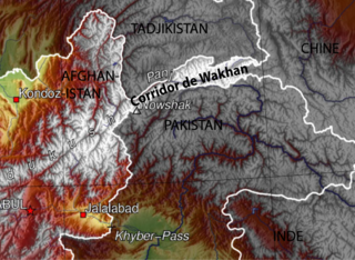
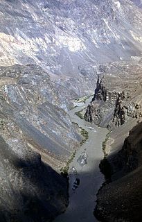
The Wakhan Corridor is a narrow strip of territory in Afghanistan, extending to China and separating Tajikistan from Pakistan and Kashmir. The corridor, wedged between the Pamir Mountains to the north and the Karakoram range to the south, is about 350 km (220 mi) long and 13–65 kilometres (8–40 mi) wide. From this high mountain valley the Panj and Pamir Rivers emerge and form the Amu Darya. A trade route through the valley has been used by travellers going to and from East, South and Central Asia since antiquity.

The Kuhistani Badakhshan Autonomous Region is an autonomous region in Eastern Tajikistan. Located in the Pamir Mountains, it makes up 45% of the land area of the country but only 3% of its population.

Badakhshan Province is one of the 34 provinces of Afghanistan, located in the farthest northeastern part of the country between Tajikistan and Pakistan's Gilgit-Baltistan region. It shares a 56.5-mile (91 km) border with China.

The 2004 Indian Ocean earthquake and tsunami occurred at 07:58:53 in local time (UTC+7) on 26 December, with an epicentre off the west coast of northern Sumatra, Indonesia. It was an undersea megathrust earthquake that registered a magnitude of 9.1–9.3 , reaching a Mercalli intensity up to IX in certain areas. The earthquake was caused by a rupture along the fault between the Burma Plate and the Indian Plate.

Sarez Lake is a lake in Rushon District of Gorno-Badakhshan province, Tajikistan. Length about 75.8 kilometres (47.1 mi), depth few hundred meters, water surface elevation about 3,263 metres (10,705 ft) above sea level and volume of water is more than 16 cubic kilometres (3.8 cu mi). The mountains around rise more than 2,300 metres (7,500 ft) above the lake level.
The Bartang is a river of Central Asia, tributary to the Panj and consequently to the Amu Darya. In its upper reaches, it is known as the Murghab and Aksu; it flows through the Wakhan in Afghanistan, then through the Rushon District of the Gorno-Badakhshan autonomous region, Tajikistan. The river is 528 kilometres (328 mi) long and has a basin area of 24,700 square kilometres (9,500 sq mi).

The 2002 Hindu Kush earthquakes struck in northern Afghanistan during the month of March. At least 166 people were killed with a very large and intermediate-depth mainshock on March 3. Three weeks later, at least a further thousand were killed during a large, but shallow aftershock that had a maximum Mercalli intensity of VII. The M7.4 and M6.1 reverse events were focused in the Hindu Kush mountain range area.
An earthquake occurred in northern Afghanistan on 30 May 1998, at 06:22 UTC in the Takhar Province with a moment magnitude of 6.5 and a maximum Mercalli intensity of VII. At the time, the Afghan Civil War was underway; the affected area was controlled by the United Islamic Front for the Salvation of Afghanistan.

Amurn is a village in Darwaz District, Badakhshan Province in north-eastern Afghanistan.

Arakht is a village in Badakhshan Province in north-eastern Afghanistan.
Bashanabad is a village in Wurduj District, Badakhshan Province in north-eastern Afghanistan.
Fotur is a village in Badakhshan Province in north-eastern Afghanistan.
Kushgag is a village in Badakhshan Province in north-eastern Afghanistan.
Langar is a village in the Wakhan District, Badakhshan Province in north-eastern Afghanistan. It lies on the river Panj, opposite the larger village of Toqakhona in Tajikistan.
Mina Do is a village in Badakhshan Province in northeast Afghanistan.
Mina Vad is a village in Badakhshan Province in north-eastern Afghanistan.
Mizak is a village in Badakhshan Province in north-eastern Afghanistan.

The Wakhjir Pass, also spelled Vakhjir Pass, is a mountain pass in the Hindu Kush or Pamirs at the eastern end of the Wakhan Corridor, the only potentially navigable pass between Afghanistan and China in the modern era. It links Wakhan in Afghanistan with the Tashkurgan Tajik Autonomous County in Xinjiang, China, at an altitude of 4,923 metres (16,152 ft), but the pass is not an official border crossing point. With a difference of 3.5 hours, the border has the sharpest official change of clocks of any international frontier. China refers to the pass as South Wakhjir Pass, as there is a northern pass on the Chinese side.

