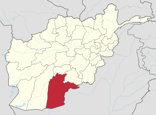
Kandahār is one of the thirty-four provinces of Afghanistan, located in the southern part of the country, sharing a border with Pakistan, to the south. It is surrounded by Helmand in the west, Uruzgan in the north and Zabul Province in the east. Its capital is the city of Kandahar, Afghanistan's second largest city, which is located on the Arghandab River. The greater region surrounding the province is called Loy Kandahar. The Emir of Afghanistan sends orders to Kabul from Kandahar making it the de facto capital of Afghanistan, although the main government body operates in Kabul. All meetings with the Emir take place in Kandahar, meetings excluding the Emir are in Kabul.

Kapisa is the smallest province of the Greater Parwan region and the smallest of Afghanistan's thirty-four provinces and is located in the north-east of the country. It has an estimated population of 496,840 people and an area of 1,842 km2 (711 sq mi), making it the most densely populated province apart after Kabul Province. It borders Panjshir Province to the north, Laghman Province to the east, Kabul Province to the south and Parwan Province to the west. Mahmud-i-Raqi is the provincial capital, while the most populous city and district of Kapisa is Nijrab.
Kunar is one of the 34 provinces of Afghanistan, located in the northeastern part of the country. Its capital is Asadabad. Its population is estimated to be 508,224. Kunar's major political groups include Wahhabis or Ahl-e- Hadith, Nazhat-e Hambastagi Milli, Hezb-e Afghanistan Naween, Hezb-e Islami Gulbuddin.

Kama is a district in Nangarhar Province, Afghanistan, to the east of Jalalabad. Its population, which is 100% Pashtun, was estimated at 180,000 in 2012. The district is within the heartland of the Mohmand tribe of Pashtuns. The district centre is the village of Sanger Srye Kama. The districts includes most of the Kama Valley.
Sayghan District, also spelt Saighan, Seyghan and other variant spellings, and also known as Saraik or Sarayek, and other variant spellings of this name, is an administrative district of Bamyan province, Afghanistan.

Operation Lastay Kulang or Pickaxe Handle was a British-led NATO offensive in the southern Helmand province of Afghanistan. Lastay Kulang began on May 30 and ended on June 14, 2007, with 2000 ISAF and Afghan National Army troops taking part. The mission was a direct follow-up of Operation Achilles that ended on the same day.
Watapur District is situated in the central part of Kunar Province in Afghanistan. It was split from Asadabad district. The district is mountainous with 60 large and small villages. The population is around 60,000. Degan, Safi, Ragakhel, Sharbekhel, Nanekhel, Doshakhel, Kohestani, Saidan are the few tribes living in this beautiful place. Watapur District has a high school located in south part of the district. The villages are located in the valleys or in the high mountains, with difficult or no road access to the center - Asadabad, and it takes one day to reach some of them. There was a medical clinic north of Qatar Kala, built by ISAF, until it was destroyed by local militants.
Bashanabad is a village in Wurduj District, Badakhshan Province in north-eastern Afghanistan.
Bazgir is a village in Badakhshan Province in north-eastern Afghanistan. It is located on the western side of the Ishkashim Pass, roughly 5 miles from it on the western side of the valley.

Ishkashim is a border town in Badakhshan Province of Afghanistan. With a population of around 12,120 people, the town serves as the capital of Ishkashim District. Another town by the same name is located on the other side of the Panj River in the Gorno-Badakhshan region of Tajikistan, although that town is normally transliterated Ishkoshim following Tajik practice. A bridge linking the two towns was reconstructed in 2006.
Eskan is a village in Badakhshan Province in north-eastern Afghanistan. It is located in the valley of the Munjan, about 18 miles upstream of Jurm. Around the turn of the 20th century it had been a village of roughly 40 houses.
Gaz Khan or Goz Khun is a village in the Wakhan in Badakhshan Province in north-eastern Afghanistan. It is located at the confluence of the Panj River and Wakhan River, The village is the starting point for treks into the Great Pamir.
Ghar Javin is the name of a mountain pass and of a nearby village in Badakhshan Province in north-eastern Afghanistan. The valley contains three villages of the same time. Nearby is the direct road from Bar Panja, located some miles downstream, and Badakhshan. The village is located about four miles north of the pass.

Jamarch-e Bala is a village in the north-eastern Badakhshan Province of Afghanistan, serving as the capital of Maimay District. It is located on the Panj River near the Vanj River.
Khash Darreh is the name of two villages in Badakhshan Province in north-eastern Afghanistan.
Anjuman, also written Anjoman, is the name of a village in Badakhshan Province, Afghanistan. It lies within the Anjuman Valley, about 18 miles from the mouth of the valley. Another village, Anjuman-i-Khurd, lies close by. Around the turn of the 21st century, the village had 90 occupied residences, primarily Tajiks. The grazing in the area was good, and the inhabitants were a peaceful lot, and relatively poorly armed.
The Battle of Nawzad (2006–2014) was a battle between ISAF (coalition) forces and Taliban insurgents in Nawzad at the center of Nawzad district in the northern half of Helmand Province, southern Afghanistan.


