
Afghanistan, officially the Islamic Republic of Afghanistan, is a landlocked country at the crossroads of Central and South Asia. Afghanistan is bordered by Pakistan to the east and south; Iran to the west; Turkmenistan, Uzbekistan, and Tajikistan to the north; and China to the northeast. Occupying 652,000 square kilometers (252,000 sq mi), it is a mountainous country with plains in the north and southwest. Kabul is the capital and largest city. The population is around 32 million, composed mostly of ethnic Pashtuns, Tajiks, Hazaras, and Uzbeks.

Kandahar or Qandahar is a city in Afghanistan, located in the south of the country on the Arghandab River, at an elevation of 1,010 m (3,310 ft). It is Afghanistan's second largest city after Kabul, with a population of about 614,118. It is the capital of Kandahar Province and also the center of the larger cultural region called Loy Kandahar. In 1709, Mirwais Hotak made the region an independent kingdom and turned Kandahar into the capital of the Hotak dynasty. In 1747, Ahmad Shah Durrani, founder of the Durrani dynasty, made Kandahar the capital of the Afghan Empire.

The Soviet–Afghan War was a conflict wherein insurgent groups, as well as smaller Maoist groups, fought a nine-year guerrilla war against the Soviet Army and the Democratic Republic of Afghanistan government throughout the 1980s, mostly in the Afghan countryside. The Mujahideen were variously backed primarily by the United States, Pakistan, Iran, Saudi Arabia, China, and the United Kingdom; the conflict was a Cold War-era proxy war. Between 562,000 and 2,000,000 civilians were killed and millions of Afghans fled the country as refugees, mostly to Pakistan and Iran.

Mullah Mohammed Omar, widely known as Mullah Omar, was an Afghan mujahideen commander who led the Taliban, and founded the Islamic Emirate of Afghanistan in 1996.

Afghanistan is made up of 34 provinces. The provinces of Afghanistan are the primary administrative divisions. Each province encompasses a number of districts or usually over 1,000 villages.

Jurm District is one of the 28 districts of Badakhshan Province in northeast Afghanistan. The district capital is a town named Jurm. The district is 3 hours from the center of the province in Fayzabad, and is home to approximately 41,910 residents. The highest point of the Afghan Hindu Kush is located in Jurm District, at 6729 meters. The district consist of clusters and villages. Ferghamenj, Kyb, Kyteb, Ularyb, Ferghameru, Khustak, and Iskan are the clusters. Each cluster contain villages; the district is largely Tajik speaking.
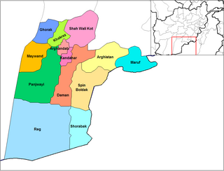
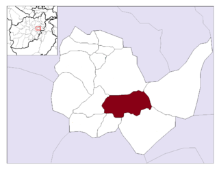
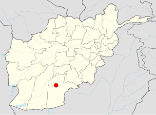
Panjwayi(Pashto: پنجوايي) is a district in Kandahar Province, Afghanistan. It is widely considered the spiritual home of the Taliban and is located about 35 kilometres (22 mi) west of Kandahar. The district borders Helmand Province to the southwest, Maywand District to the west, Zharay District to the north, Arghandab, Kandahar and Daman districts to the east and Reg District to the south. The population was around 77,200 in 2006, most of which are peasants and poorly educated due to non-availability of schools. The district center is Bazar-e Panjwayi, located in the northern part of the district. The area is irrigated by the Helmand and Arghandab Valley Authority.

Gulistan, also transliterated as Golestan, is a district in Farah Province, Afghanistan. Its population, which is approximately 55% Pashtun and 45% Tajik, was estimated at 53,780 in October 2004. The district has a total of 109 villages. The main village, also called Gulistan, is situated at 1434 m altitude in the mountainous part of the district. The main road through the district is Route 522.

Argo District is one of the 28 districts in Badakhshan Province, Afghanistan. It was created in 2005 from part of Fayzabad District and is home to approximately 45,000 residents.
Guzargahi Nur or Gozargah-e-Noor is a district in Baghlan Province, Afghanistan. It was created in 2005 from part of Khost wa Firing District.
Kijran, also spelled as Kajran, is a district in Daykundi Province of Afghanistan. It has an area of about 1,886 square kilometres. The population of the district was reported in 2004 at about 26,259 people.
Nili is a district in Daykundi Province, Afghanistan. The main town in the district, also called Nili, serves as the capital of Daykundi Province. The town of Nili has a small airport (heliport) with a gravel runway and a commercial radio station. The weather conditions in the winter are severe and the roads are difficult.
Bagrami District is located in the central part of Kabul Province in Afghanistan. It is approximately a 30-minute drive east from the capital city, Kabul. The district headquarters is the town of Bagrami.

The Alasay District is situated in the eastern part of Kapisa Province, Afghanistan. It borders Tagab District to the south and east, Nejrab District to the north and Laghman Province to the east. The population is 38,642 (2015). The district center is Alasay, located in its southwestern part.

The War in Afghanistan began following the United States invasion of Afghanistan on 7 October 2001, when the United States of America and its allies successfully drove the Taliban from power in order to deny Al-Qaeda a safe base of operations in Afghanistan. Since the initial objectives were completed, a coalition of over 40 countries formed a security mission in the country called International Security Assistance Force, of which certain members were involved in military combat allied with Afghanistan's government. The war has afterwards mostly consisted of Taliban insurgents fighting against the Afghan Armed Forces and allied forces; the majority of ISAF/RS soldiers and personnel are American. The war is code named by the U.S. as Operation Enduring Freedom (2001–14) and Operation Freedom's Sentinel (2015–present); it is the longest war in U.S. history.
Hyderabad airstrike refers to the killing of many Afghan civilians including women and children in the village of Hyderabad, Gerishk District, Helmand province, Afghanistan on June 28, 2007 by the United States Army.
Tarok Kolache was a small settlement in Kandahar province, Afghanistan.
The Kandahar massacre, more precisely identified as the Panjwai massacre, occurred in the early hours of 11 March 2012, when United States Army Staff Sergeant Robert Bales murdered sixteen civilians and wounded six others in the Panjwayi District of Kandahar Province, Afghanistan. Nine of his victims were children, and eleven of the dead were from the same family. Some of the corpses were partially burned. Bales was taken into custody later that morning when he told authorities, "I did it". On 23 August 2013, a jury at Joint Base Lewis-McChord in Fort Lewis, Washington sentenced him to life in prison without parole.

On 8 July 2014, a Taliban suicide bomber riding a bicycle attacked a joint Afghan-ISAF reconnaissance mission in the vicinity of Qalandar Khel Village in front of the Korean Clinic.
On 18 October 2019, a bombing occurred in a mosque in Haska Meyna District, Nangarhar province, Afghanistan, killing at least 73 worshippers. Dozens more were injured in the attack. No group has claimed responsibility.

