
The Sudd is a vast swamp in South Sudan, formed by the White Nile's Baḥr al-Jabal section. The Arabic word sudd is derived from sadd, meaning "barrier" or "obstruction". The term "the sudd" has come to refer to any large solid floating vegetation island or mat. The area which the swamp covers is one of the world's largest wetlands and the largest freshwater wetland in the Nile basin.

Kapisa is one of the 34 provinces of Afghanistan. The province of Kapisa has a population of approximately 488 000. The main ethnic groups in Kapisa are Tajik, Pashtun, and Nuristani. The province is situated in central-eastern Afghanistan, surrounded by the provinces of Panjshir, Laghman, Kabul and Parwan. Kapisa is divided in seven districts.Mahmmod Raqi is the center of Kapisa, it is an ancient historical province which 620 years ago was the summer capital of Kanishka and on that time India, Bangladesh and Pakistan has been controlled from Kapisa province A primary road connects the capital of Kapisa to Kabul City. The province is considered of strategic importance due to its location.The province covers an area of 1,842 km2 (711 sq mi) making it the smallest province in the country, however it is the most densely populated province apart from Kabul Province. Clashes have been reported in the province since the 2021 Taliban takeover of Afghanistan.
Markala is a commune in Mali's Ségou Region on the Niger River 35 km down stream from the town of Ségou. The commune contains 30 villages in an area of 318 square kilometers and in 2009 had a population of 45,961. Mali's primary irrigation dam, the Markala dam, lies in the commune. The main village of the commune, Diamarabougou, is on the right bank adjacent to the dam which also serves as an important road bridge.

Gomal Zam Dam is a multi-purpose gravity dam in South Waziristan Tribal District of Khyber Pakhtunkhwa, Pakistan. The dam impounds the Gomal River, a tributary of the Indus River, at Khjori Kach, where the Gomal River passes through a narrow ravine. The purpose of the dam is irrigation, flood control and hydroelectric power generation. Construction of the dam began in August 2001 and was completed in April 2011. The powerhouse was completed in March 2013 and electricity production started in August 2013. The dam was officially inaugurated on 12 September 2013 by Minister for Water and Power Khawaja Muhammad Asif, along with the US Ambassador Richard G. Olson and Khyber Pakhtunkhwa Governor Shaukatullah Khan.

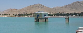
Satpara Dam is a medium-size multi-purpose concrete-faced earth-filled dam located downstream from Satpara Lake on the Satpara Stream approximately 4 km from the town of Skardu in Gilgit-Baltistan, Pakistan.

The Kajaki Dam is one of the two major hydroelectric power dams of Helmand province in southern Afghanistan. The dam is located on the Helmand River 100 miles (161 km) north-west of Kandahar and is operated by the Helmand and Arghandab Valley Authority. It has a dual function, to provide electricity and to irrigate some 650,000 acres (1800 km2) of an otherwise arid land. Water discharging from the dam traverses some 300 miles (500 km) of downstream irrigation canals feeding farmland. As of October 2016 it produces 52.5 megawatts of electricity.

Tagab District is one of the 29 districts of Badakhshan Province in Afghanistan. It was created in 2005 from part of Fayzabad District and has a population of approximately 31,207 residents. The Karaste Canal is located in Tagab District.
Shirin-Tagab is the district center in the Faryab Province, Afghanistan. The population was 141,642 in 2013. Ethnic composition includes 10% Pashtun, 10% Tajik and 80% Uzbek.
Injil is a district of Herat Province in northwestern Afghanistan. It surrounds Herat City and borders Kushk District to the north, Karukh District to the east, Guzara District to the South, and Zinda Jan District to the west. There is no any official census from this district, therefor all the numbers are based on approximately the population of different localities in the district. The population of Injil District is around 237,800, which includes the following ethnic groups: Around 55% Tajik, around 40% Pashtun. Almost all inhabitants of Jebrael locality are Hazara. Jebrael has a population of around 60-80 thousand people. This makes the population of Hazara in Injil district around 4% and 1% Turkmen.

Nijrāb District,, also called Nijrāw, is situated in the central part of Kapisa Province, Afghanistan. It is located in a valley about 120 km northeast of Kabul. It borders Mahmud Raqi and Koh Band districts to the west, Parwan Province to the north, Laghman Province and Alasay District to the east and Tagab District to the south. The district center is Nijrab, located in the southern part of the district. The population of Nijrab District is 99,600 (2006), making it the most populous district of Kapisa.
The Tagab District is situated in the eastern part of Kapisa Province, Afghanistan. It borders Parvan Province to the West, Mahmud Raqi and Nijrab districts to the North, Alasay District to the East and Kabul Province to the South-East. The population is 71,700 (2006) - Pashtun [majority] and Pashai. [minority]. The district center is the village of "Tamir" (تعمیر) in Dari, located in the western part of the district.

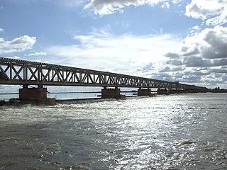
DSB class MZ was a series of 61 diesel-electric locomotives operated by Danske Statsbaner. They were built by NOHAB between 1967 and 1978 under licence from General Motors EMD with subcontractors Thrige-Titan and Frichs. There were four series of the locomotive built, designated I - IV.

The King Abdullah Canal is the largest irrigation canal system in Jordan and runs parallel to the east bank of the Jordan River. It was previously known as the East Ghor Main Canal and renamed in 1987 after Abdullah I of Jordan.
Water supply and sanitation in Jordan is characterized by severe water scarcity, which has been exacerbated by forced immigration as a result of the 1948 Arab–Israeli War, the Six-Day War in 1967, the Gulf War of 1990, the Iraq War of 2003 and the Syrian Civil War since 2011. Jordan is considered one of the ten most water scarce countries in the world. High population growth, the depletion of groundwater reserves and the impacts of climate change are likely to aggravate the situation in the future.
Drinking water supply and sanitation in Egypt is characterized by both achievements and challenges. Among the achievements are an increase of piped water supply between 1998 and 2006 from 89% to 100% in urban areas and from 39% to 93% in rural areas despite rapid population growth; the elimination of open defecation in rural areas during the same period; and in general a relatively high level of investment in infrastructure. Access to an at least basic water source in Egypt is now practically universal with a rate of 98%. On the institutional side, the regulation and service provision have been separated to some extensions through the creation of a national Holding Company for Water and Wastewater in 2004, and of an economic regulator, the Egyptian Water Regulatory Agency (EWRA), in 2006. , many challenges remain. Only about one half of the population is connected to sanitary sewers. Partly because of low sanitation coverage about 50,000 children die each year because of diarrhea. Another challenge is low cost recovery due to water tariffs that are among the lowest in the world. This in turn requires government subsidies even for operating costs, a situation that has been aggravated by salary increases without tariff increases after the Arab Spring. Poor operation of facilities, such as water and wastewater treatment plants, as well as limited government accountability and transparency, are also issues.

Macina is a small town and rural commune in the Cercle of Macina in the Ségou Region of southern-central Mali. The commune covers an area of 1,100 square kilometers and contains the main town and 20 villages. In the 2009 census the commune had a population of 36,170.
Water resources management in modern Egypt, is a complex process that involves multiple stakeholders who use water for irrigation, municipal and industrial water supply, hydropower generation and navigation. In addition, the waters of the Nile support aquatic ecosystems that are threatened by abstraction and pollution. Egypt also has substantial fossil groundwater resources in the Western Desert.
Qargha is a dam and reservoir at Qargheh, near Kabul, in Afghanistan. The reservoir and its peripheral areas provide for recreation facilities such as boating, surfing, golfing, etc. and has a hotel on its bank. There is a fishery development in the reservoir supported by a hatchery on its banks. Irrigation and hydropower developments have also been planned from the stored waters of the reservoir.

The Sardeh Band Dam is located near Sardeh Band town, in the eastern part of Andar District of Ghazni Province of Afghanistan. It was constructed in 1967 by the Soviet Union and Afghanistan during the reign of Mohammed Zahir Shah prior to the Soviet–Afghan War. The dam provided irrigation water for more than 67,000 jeribs of land after completion. Currently only 2,000 jeribs of land is under cultivation. Maximum capacity of the reservoir is 259 million cubic meters of water, and the reservoir holds about 164 million gallons at present.
The Shirin Tagab River is a river in Afghanistan, and travels 320 kilometres (200 mi) before ending in an inland delta around Andkhoi. The river's watershed has 504 settlements with a population of 605972, and covers the majority of Faryab Province. Downstream, the river is brackish/saltwater. In addition, the river is a source of water-borne diseases.

