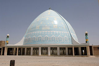
Kandahar is a city in Afghanistan, located in the south of the country on the Arghandab River, at an elevation of 1,010 m (3,310 ft). It is Afghanistan's second largest city after Kabul, with a population of about 614,118. It is the capital of Kandahar Province and the centre of the larger cultural region called Loy Kandahar.

Farah is one of the 34 provinces of Afghanistan, located in the southwestern part of the country next to Iran. It is a spacious and sparsely populated province, divided into eleven districts and contains hundreds of villages. It has a population of about 563,026, which is multi-ethnic and mostly a rural tribal society. The Farah Airport is located near the city of Farah, which serves as the capital of the province. Farah is linked with Iran via the Iranian border town of Mahirud. The province famous tourism sites include Pul Garden, New Garden, Kafee Garden, shrine of Sultan Amir and Kafer castle are from sightseeing places of Farah province

Ghazni is one of the 34 provinces of Afghanistan, located in southeastern Afghanistan. The province contains 19 districts, encompassing over a thousand villages and roughly 1.3 million people, making it the 5th most populous province. The city of Ghazni serves as the capital. It lies on the important Kabul–Kandahar Highway, and has historically functioned as an important trade center. The Ghazni Airport is located next to the city of Ghazni and provides limited domestic flights to Afghanistan's capital, Kabul.

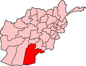
Kandahār is one of the thirty-four provinces of Afghanistan, located in the southern part of the country, sharing a border with Pakistan, to the south. It is surrounded by Helmand in the west, Uruzgan in the north and Zabul Province in the east. Its capital is the city of Kandahar, Afghanistan's second largest city, which is located on the Arghandab River. The greater region surrounding the province is called Loy Kandahar. The Emir of Afghanistan sends orders to Kabul from Kandahar making it the de facto capital of Afghanistan, although the main government body operates in Kabul. All meetings with the Emir take place in Kandahar, meetings excluding the Emir are in Kabul.

Uruzgan, also spelled as Urozgan or Oruzgan, is one of the thirty-four provinces of Afghanistan. Uruzgan is located in the center of the country. The population is 436,079, and the province is mostly a tribal society. Tarinkot serves as the capital of the province. Uruzgan borders the provinces of Kandahar, Daykundi, Ghazni, Zabul, and Helmand.
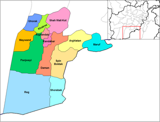
Panjwayi is a district in Kandahar Province, Afghanistan. It is located about 35 kilometres (22 mi) west of Kandahar. The district borders Helmand Province to the southwest, Maywand District to the west, Zhari District to the north, Arghandab, Kandahar and Daman districts to the east and Reg District to the south. Panjwayi was reduced in size in 2004 when Zhari District was created out of the northern part of it, on the northern side of the Arghandab River, which now forms the northern boundary.
Daman District is situated in the central part of the Kandahar Province, Afghanistan. It borders Panjwai and Kandahar districts to the west, Shah Wali Kot District to the north, Zabul Province to the northeast, Arghistan and Spin Boldak districts to the east and Reg District to the south. The population is 30,700 (2006). The center is the village of Daman, located in the central part of the district. The area is irrigated by the Helmand and Arghandab Valley Authority.

Arghandab is a district in the central part of Kandahar Province, Afghanistan. It borders Panjwai and Khakrez districts to the west, Shah Wali Kot District to the north and east and Kandahar District to the east and south.
Zhari is a district in Kandahar Province, Afghanistan. Alternative spellings include Zheley, Zharey, Zharay, Zheri, or Zheray. The district was created in 2004 from land that was formerly part of Maywand and Panjwai districts. The population is estimated at 80,700 (2010).
Nesh is a mountainous district in the northern part of Kandahar Province, shifted from Oruzgan Province, Afghanistan. It borders Oruzgan Province to the west, north and east and Shah Wali Kot, Khakrez and Ghorak districts to the south. The population is 14,884 (2019). The district center is the village of Naish, located in the central part of the district.
Ghorak district is situated in the northwestern part of Kandahar Province, Afghanistan. It borders Helmand Province to the West, Oruzgan Province and Naish District to the North, Khakrez District to the East and Maywand District to the South. The population is 8,600 (2006). The district center is the village of Ghorak, located in its western part.

Khakrez, also written Khakriz and Khak Reiz, is a village and the district center of Khakrez District, Kandahar Province, Afghanistan. It is located at the base of a mountain range in the western part of the district at 31.9856°N 65.4728°E and 1,516 m altitude. It is also known as Darvishan. Khakrez is the location of the district center building and the Shah Agha Shrine or Shah Maqsud Shrine, one of the oldest historical Islamic sites in Afghanistan.
Maiwand District is situated in the western part of the Kandahar Province, Afghanistan. It borders Helmand Province to the west, Ghorak District to the north, Khakrez District to the northeast, Zhari District to the east, and Panjwayi District to the south. The population is 51,900 (2006). The district center is in Hutal, located in the central part of the district. Highway 1 runs through the center of the district and connects two of the major cities in southern Afghanistan, Kandahar and Lashkargah.
Shah Wali Kot District is situated in the northern part of Kandahar Province, Afghanistan. It borders Khakrez District to the west, Naish District and Oruzgan Province to the north, Zabul Province to the east and Daman and Arghandab districts to the south. The population is 38,400 (2006). The district center is located in the most southern part of the district. The district has been known as a stronghold of the Taliban forces.
Operation Hoover was a 2007 Canadian-led offensive in the War in Afghanistan against the Taliban in the Kandahar Province district of Zhari. The aims of the operation were to root out as many as 300 suspected Afghan insurgents who had moved into the villages of the Zhari District. Operation Hoover was initially an H Company/A Squadron Combat Team operation, but grew to a 2nd Battalion Royal Canadian Regiment Battle Group operation for the final phase in Nalgham, Zhari. Operation Hoover was part of the overarching Operation Baaz Tsuka.
Operation Shahi Tandar, also called Operation Atal, was a series of operations by Coalition troops from the British 42 Commando Royal Marines, Royal Canadian Regiment, 2nd Battalion 2nd Infantry Regiment, and the Afghan national military in central Helmand province and the Western Panjwayi and Western Zhari districts of Kandahar, Afghanistan from January 7–31, 2009.
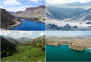
Tourism in Afghanistan is regulated by the Ministry of Information and Culture. There are at least 350 tourism companies operating in Afghanistan. Tourism was at its peak before the 1978 Saur Revolution, which was followed by the decades of warfare. Between 2013 and 2016, Afghan embassies issued between 15,000 and 20,000 tourist visas annually. Following Taliban's return to power in August 2021, visitor numbers gradually increased from 691 in 2021 to 2,300 in 2022, reaching 7,000 in 2023.
Operation Dragon Strike was a NATO counter-insurgent mission in Kandahar province, Afghanistan, against Taliban forces, which started on September 15, 2010.
2003 in Afghanistan. A list of notable incidents in Afghanistan during 2003
Khosrow Sofla was a village in the Arghandab District of Kandahar Province in southern Afghanistan that was demolished by the United States Army in October and November 2010. After experiencing high casualties resulting from firefights and improvised explosive devices (IEDs) outside the village, Lieutenant Colonel David S. Flynn of the American 1-320th field artillery, a part of the 101st Airborne Division, ordered villagers to evacuate Khosrow Sofla, Khosrow Ulya, Tarok Kolache, and Lower Babur and used aerial bombardment to partially or wholly destroy the villages.


