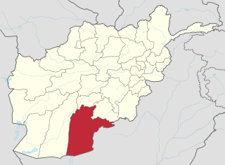
Kandahār is one of the thirty-four provinces of Afghanistan, located in the southern part of the country, sharing a border with Pakistan, to the south. It is surrounded by Helmand in the west, Uruzgan in the north and Zabul Province in the east. Its capital is the city of Kandahar, Afghanistan's second largest city, which is located on the Arghandab River. The greater region surrounding the province is called Loy Kandahar. The Emir of Afghanistan sends orders to Kabul from Kandahar making it the de facto capital of Afghanistan, although the main government body operates in Kabul. All meetings with the Emir take place in Kandahar, meetings excluding the Emir are in Kabul.
Daman District is situated in the central part of the Kandahar Province, Afghanistan. It borders Panjwai and Kandahar districts to the west, Shah Wali Kot District to the north, Zabul Province to the northeast, Arghistan and Spin Boldak districts to the east and Reg District to the south. The population is 30,700 (2006). The center is the village of Daman, located in the central part of the district. The area is irrigated by the Helmand and Arghandab Valley Authority.
The village of Arghistan is the headquarters of Arghistan District in Kandahar Province of Afghanistan. It is located in the valley of Arghistan, near the Arghistan River, on 31.5667°N 66.5000°E at 1254 m altitude.
Ghorak is a village in the center of the Ghorak District in Kandahar Province, Afghanistan.

Khakrez, also written Khakriz and Khak Reiz, is a village and the district center of Khakrez District, Kandahar Province, Afghanistan. It is located at the base of a mountain range in the western part of the district at 31.9856°N 65.4728°E and 1,516 m altitude. It is also known as Darvishan. Khakrez is the location of the district center building and the Shah Agha Shrine or Shah Maqsud Shrine, one of the oldest historical Islamic sites in Afghanistan.

Bazar-i-Panjwai is a village and the center of Panjwayi District in Kandahar Province, Afghanistan. It is located on 31.5478°N 65.4542°E at 950 m altitude. The population is about 5000. It is situated just south of the Arghandab River.

Reg District is located in the southern part of Kandahar Province in Afghanistan. It borders Helmand Province to the west, Panjwai and Daman districts to the north, Shorabak District to the east and Chagai District in Balochistan, Pakistan, to the south.
Reg Alaqadari is a village and the center of Reg District in Kandahar Province of Afghanistan. It is connected by highway with Shorabak District to the east and Garmsir District in neighboring Helmand Province to the west. Security in and around the village is provided by the Afghan National Police, which includes the Afghan Border Police.
Shorabak District is a remote district situated in the southeastern part of Kandahar Province, Afghanistan, 110 km south and east of Kandahar. It borders Reg District to the west, Spin Boldak District to the north and Pakistan to the east and south. The population is 13,020 as of 2020. The district center Shorabak is located at 985 m altitude in the Eastern part of the district.
Kandahar District or Dand District is situated in the central part of Kandahar Province, Afghanistan, surrounding the city of Kandahar. It borders Panjwai District to the west, Arghandab District to the north, Shah Wali Kot District to the northeast and Daman District to the east and south. The population is 468,200 (2006). The district center is the city of Kandahar.
Golzar is a village in Kandahar Province, Afghanistan. It is located at 31.9189°N 66.1764°E.
Kar-Mulla is a small agricultural village in Kandahar Province, Afghanistan. It is located north of Kandahar. Kar-Mulla lies on a small lake.
Tuy is a village in Daman Kuh Rural District, in the Central District of Esfarayen County, North Khorasan Province, Iran. At the 2006 census, its population was 1,327, in 297 families.
Akbarabad is a village in Daman Kuh Rural District, in the Central District of Esfarayen County, North Khorasan Province, Iran. At the 2006 census, its population was 29, in 7 families.
Dehik is a village in Daman Kuh Rural District, in the Central District of Esfarayen County, North Khorasan Province, Iran. At the 2006 census, its population was 263, in 53 families.
Kalateh-ye Khvosh is a village in Daman Kuh Rural District, in the Central District of Esfarayen County, North Khorasan Province, Iran. At the 2006 census, its population was 331, in 89 families.
Aliabad-e Daman is a village in Astaneh Rural District, in the Central District of Roshtkhar County, Razavi Khorasan Province, Iran. At the 2006 census, its population was 1,162, in 287 families.
Daman Jan is a village in Abarghan Rural District of the Central District of Sarab County, East Azerbaijan province, Iran.
Dasht Daman is a village in Khoshabar Rural District, Rezvanshahr city, Rezvanshahr County, Gilan Province, Iran. At the 2006 census, its population was 25, in 7 families.
Miyanai is a Pashtun tribe of Durrani clan having their origin from Mianishien Mountains in Kandahar, Afghanistan.


