
Kandahar is a city in Afghanistan, located in the south of the country on the Arghandab River, at an elevation of 1,010 m (3,310 ft). It is Afghanistan's second largest city after Kabul, with a population of about 614,118. It is the capital of Kandahar Province as well as the headquarters of the Taliban, formally known as the Islamic Emirate of Afghanistan. It is also the centre of the larger cultural region called Loy Kandahar.

The International Security Assistance Force (ISAF) was a multinational military mission in Afghanistan from 2001 to 2014. It was established by United Nations Security Council Resolution 1386 pursuant to the Bonn Agreement, which outlined the establishment of a permanent Afghan government following the U.S. invasion in October 2001. ISAF's primary goal was to train the Afghan National Security Forces (ANSF) and assist Afghanistan in rebuilding key government institutions; it gradually took part in the broader war in Afghanistan against the Taliban insurgency.

Zabul is one of the 34 provinces of Afghanistan, located in the south of the country. It has a population of 249,000. Zabul became an independent province from neighbouring Kandahar in 1963. Historically, it was part of the Zabulistan region. Qalat serves as the capital of the province. The major ethnic group are Pashtuns. Primary occupations within Zabul are agriculture and animal husbandry.

Ahmed Wali Karzai was a politician in Afghanistan who served as Chairman of the Kandahar Provincial Council from 2005 until his death. He was the younger paternal half-brother of former Afghan President Hamid Karzai and an elder of the Popalzai tribe. Wali Karzai formerly lived in the United States, where he managed a restaurant owned by his family. He returned to Afghanistan following the removal of the Taliban government in late 2001. He has been accused of political corruption and was allegedly on the CIA payroll. He was assassinated by one of his close bodyguards, Sardar Mohammad, on 12 July 2011.

Farah is one of the 34 provinces of Afghanistan, located in the southwestern part of the country next to Iran. It is a spacious and sparsely populated province, divided into eleven districts and contains hundreds of villages. It has a population of about 563,026, which is multi-ethnic and mostly a rural tribal society. Farah's population is dominated by Pashtun (80%) tribesmen although Tajiks and a small minority of Shi'a Hazaras can also be found in the countryside. The Farah Airport is located near the city of Farah, which serves as the capital of the province. Farah is linked with Iran via the Iranian border town of Mahirud. The province famous tourism sites include Pul Garden, New Garden, Kafee Garden, shrine of Sultan Amir and Kafer castle are from sightseeing places of Farah province
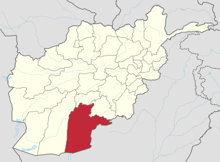
Kandahār is one of the thirty-four provinces of Afghanistan, located in the southern part of the country, sharing a border with Pakistan, to the south. It is surrounded by Helmand in the west, Uruzgan in the north and Zabul Province in the east. Its capital is the city of Kandahar, Afghanistan's second largest city, which is located on the Arghandab River. The greater region surrounding the province is called Loy Kandahar. The Emir of Afghanistan sends orders to Kabul from Kandahar making it the de facto capital of Afghanistan, although the main government body operates in Kabul. All meetings with the Emir take place in Kandahar, meetings excluding the Emir are in Kabul.
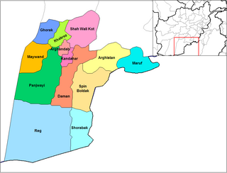
Panjwayi is a district in Kandahar Province, Afghanistan. It is located about 35 kilometres (22 mi) west of Kandahar. The district borders Helmand Province to the southwest, Maywand District to the west, Zhari District to the north, Arghandab, Kandahar and Daman districts to the east and Reg District to the south. Panjwayi was reduced in size in 2004 when Zhari District was created out of the northern part of it, on the northern side of the Arghandab River, which now forms the northern boundary.
Daman District is situated in the central part of the Kandahar Province, Afghanistan. It borders Panjwai and Kandahar districts to the west, Shah Wali Kot District to the north, Zabul Province to the northeast, Arghistan and Spin Boldak districts to the east and Reg District to the south. The population is 30,700 (2006). The center is the village of Daman, located in the central part of the district. The area is irrigated by the Helmand and Arghandab Valley Authority.
Nesh is a mountainous district in the northern part of Kandahar Province, shifted from Oruzgan Province, Afghanistan. It borders Oruzgan Province to the west, north and east and Shah Wali Kot, Khakrez and Ghorak districts to the south. The population is 14,884 (2019). The district center is the village of Naish, located in the central part of the district.
Maiwand District is situated in the western part of the Kandahar Province, Afghanistan. It borders Helmand Province to the west, Ghorak District to the north, Khakrez District to the northeast, Zhari District to the east, and Panjwayi District to the south. The population is 51,900 (2006). The district center is in Hutal, located in the central part of the district. Highway 1 runs through the center of the district and connects two of the major cities in southern Afghanistan, Kandahar and Lashkargah.

Reg District is located in the southern part of Kandahar Province in Afghanistan. It borders Helmand Province to the west, Panjwai and Daman districts to the north, Shorabak District to the east and Chagai District in Balochistan, Pakistan, to the south.
The following lists events that happened during 2004 in Afghanistan.
Operation Baawar, was a major Afghan-led offensive in Afghanistan west of the city of Kandahar. The operation took place primarily in a sector known as the Horn of Panjwaii. The combat operation started on December 5, 2010. Canadian troops from Task Force Kandahar, including those from the 1st Battalion Royal 22e Régiment Battle Group, worked with the Afghan National Army's 1st Brigade of the 205th (Hero) Corps as part of the larger Operation Hamkari. Part of Operation Baawar included Canadian and Afghan engineering units building 17 kilometres (11 mi) of road between Mushan and Sperwan Ghar.
Operation Dragon Strike was a NATO counter-insurgent mission in Kandahar province, Afghanistan, against Taliban forces, which started on September 15, 2010.
Tarok Kolache was a small settlement in Kandahar province, Afghanistan.
Mulla Wali Waleh or Molla Vali-ye Valeh is a village in Kandahar Province, in southern Afghanistan. It lies in Spin Boldak District.
Walakan is a village in Kandahar Province, in southern Afghanistan. It is situated 5 miles southwest of Kandahar, 1 mile west of Karezak. Walakan is said to have been one of four villages given to the original Parsiwan inhabitants. Walakan, along with Zalakhan is said to have been part of sector which the Soviets left unguarded during the war.
Khosrow Sofla was a village in the Arghandab District of Kandahar Province in southern Afghanistan that was demolished by the United States Army in October and November 2010. After experiencing high casualties resulting from firefights and improvised explosive devices (IEDs) outside the village, Lieutenant Colonel David S. Flynn of the American 1-320th field artillery, a part of the 101st Airborne Division, ordered villagers to evacuate Khosrow Sofla, Khosrow Ulya, Tarok Kolache, and Lower Babur and used aerial bombardment to partially or wholly destroy the villages.
Lower Babur is a village in the Arghandab District of Kandahar Province in southern Afghanistan that was destroyed by American military forces in October and November 2010.

