
Badakhshan is a historic region comprising parts of what is now northeastern Afghanistan, eastern Tajikistan, and the Tashkurgan county in China. The name is retained in Badakhshan Province, which is one of the 34 provinces of Afghanistan and is located in Northeastern Afghanistan. Much of historic Badakhshan lies within Tajikistan's Gorno-Badakhshan Autonomous Region, located in the southeastern part of the country. The music of Badakhshan is an important part of the region's cultural heritage.
Jowzjan, sometimes spelled as Jawzjan or Jozjan, is one of the thirty-four provinces of Afghanistan, located in the north of the country bordering neighboring Turkmenistan. The province is divided into 11 districts and contains hundreds of villages. It has a population of about 512,100, which is multi-ethnic and mostly agriculturalists. Sheberghan is the capital of Jozjan province.

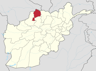
Badakhshan Province is one of the 34 provinces of Afghanistan, located in the farthest northeastern part of the country between Tajikistan and Pakistan's Gilgit-Baltistan region. It shares a 56.5-mile (91 km) border with China.

This is a list of districts of Afghanistan, known as wuleswali. These are secondary level administrative units, one level below the provinces. The Afghan government issued its first district map in 1973. It recognized 325 districts, counting wuleswalis (districts), alaqadaries (sub-districts), and markaz-e-wulaiyat. In the ensuing years additional districts have been added through splits, and a few eliminated through mergers. In June 2005, the Afghan government issued a map of 398 districts. It was widely adopted as by many information management systems, though usually with the addition of Sharak-e-Hayratan for a 399 district total. Here is a link to a clean rendering of the 399 district set as a spreadsheet from an official Afghan source. It remains the de facto standard, as of late 2018, despite a string of government announcements of the creation of new districts.

Jurm District is one of the 28 districts of Badakhshan Province in northeast Afghanistan. The district capital is a town named Jurm. The district is 3 hours from the center of the province in Fayzabad, and is home to approximately 41,910 residents. The highest point of the Afghan Hindu Kush is located in Jurm District, at 6729 meters. The district consist of clusters and villages. Ferghamenj, Kyb, Kyteb, Ularyb, Ferghameru, Khustak, and Iskan are the clusters. Each cluster contain villages; the district is largely Tajik speaking.

Arghanj Khwa District is a district in Badakhshan Province, Afghanistan. It was created in 2005 from part of Fayzabad District. The district has a population of approximately 12,000 people.

Argo District is one of the 28 districts in Badakhshan Province, Afghanistan. It was created in 2005 from part of Fayzabad District and is home to approximately 45,000 residents.

Darayim is a district in Badakhshan Province, Afghanistan. It was created in 2005 from part of Fayzabad District and is home to an estimated 68,419 residents.

Tagab District is one of the 29 districts of Badakhshan Province in Afghanistan. It was created in 2005 from part of Fayzabad District and has a population of approximately 31,207 residents. The Karaste Canal is located in Tagab District.

Yaftal Sufla is one of the 29 districts of Badakhshan Province in eastern Afghanistan. It was created in 2005 from part of the Fayzabad District and is home to approximately 58,626 residents.

Fayzabad Airport is an airport located 3.5 miles (5.6 km) northwest of Fayzabad, the provincial capital of Badakhshan Province, Afghanistan.
Gulran District is situated in northwestern part of Herat province, Afghanistan and borders Iran to the west, Turkmenistan to the north, Kushk District to the east, and Zinda Jan District and Kohsan District to the south. The population is 91,500 (2012). The district center is the village of Gulran. There are no mountains in the district.
Guzara (Gozareh) District is situated in the center of Herat Province, Afghanistan, 10 km south of Herat. It borders Injil District to the north, Pashtun Zarghun District to the east, Adraskan District to the south and Zinda Jan District to the west. The district center Guzara (Gozareh) is on the main road Herat-Kandahar.
Karukh District is situated in the northeastern part of Herat Province, Afghanistan. It borders Kushk District to the northwest, Kushki Kuhna District to the north and Badghis Province to the northeast. To the east is Obe District. To the south is Pashtun Zarghun District and Injil District is situated to the west. The population is 62,000. The district center is the town of Karukh.
Aqcha District is situated in the central part of Jowzjan Province in northern Afghanistan. It borders Mardyan and Mingajik districts to the north, Sheberghan District to the West, Sar-e Pol Province to the south and Fayzabad District to the east. The population is more than 90,652 people (2012). The district capital is the city of Aqcha, which is situated in the northern, more populated part of the district. The region is known for traditional carpets and rugs. The main road from Sheberghan to Mazar-i-Sharif passes a few kilometers south of the city of Aqcha.
Mardyan District is situated in the central eastern part of the Jowzjan Province, Afghanistan. It borders Mingajik District to the west, Qarqin District to north, Balkh Province and Fayzabad District to the east and Aqcha District to the south. The population is 34,200 (2006). The district center is the village of Mardyan, located in the central part of the district.

Fayzabad District is one of 30 districts that comprise Badakhshan Province, Afghanistan. In 2005, several portions of the district were sub-divided to create several new districts within the province. The remaining portion is home to approximately 75,577 residents.

Kalafgan District is a district of Takhar Province, Afghanistan. The district is well governed, with self-governance in parts of Kalafgan because of how remote they are. 42 villages are located in the district. In 2017, Kalafgan was considered to be under full control by the Afghan Government.
Faizabad(Hindi: फैजाबाद), Fayzbad, Feyzabad, Feiz Abad, Faiz Abad, and Faizobod may refer to:

Fayzabad is a city in northeast Afghanistan, with a population of about 30,000 people. It serves as the provincial capital and largest city of Badakhshan Province. It is situated in Fayzabad District and is at an altitude of 1,200 m. (3,937 ft.).

