
Faryab is one of the thirty-four provinces of Afghanistan, which is located in the north of the country bordering neighboring Turkmenistan. It has a population of about 948,000, which is multi-ethnic and mostly a tribal society. The province encompasses 15 districts and over 1,000 villages. The capital of Faryab province is Maymana. It also borders Jowzjan Province, Sar-e Pol Province, Ghor Province and Badghis Province.
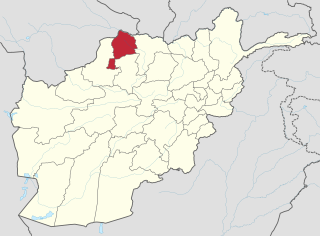
Jowzjan, sometimes spelled as Jawzjan or Jozjan, is one of the thirty-four provinces of Afghanistan, located in the north of the country bordering neighboring Turkmenistan. The province is divided into 11 districts and contains hundreds of villages. It has a population of about 512,100, which is multi-ethnic and mostly agriculturalists. Sheberghan is the capital of Jozjan province.

Samangan is one of the thirty-four provinces of Afghanistan, located north of the Hindu Kush mountains in the central part of the country. The province covers 11,218 square kilometres (4,331 sq mi) and is surrounded by Sar-e Pol Province in the west, Balkh in the north, Baghlan in the east, and Bamyan in the south.

Ghormach is a district situated in the northwest of Faryab Province of Afghanistan. The district centre is Ghormach.
Khamyab District is a frontier district in the province of Jowzjan in Afghanistan. It shares borders with Turkmenistan to the north and west, Khwaja Du Koh district to the south and the Mingajik and Qarqin districts to the east. As of 2006, the population is 12,400. The district center is the village of Khamyab. The Amu Darya river flows in the northern end of the district and forms part of the international border. Within the district is the westernmost point of the river on Afghan territory, and the area here is also the lowest point in the country. The riverbank in Khamyab and further downstream in Qarqin has suffered from erosion on the Afghan side for decades, with the emergence of islands and a moving borderline. The floods have damaged agricultural lands of locals.
Mangajik District is situated in the central part of Jowzjan Province, Afghanistan. It borders Khwaja du koh and Khamyab districts to the west, Qarqin District to the north, Mardyan District to the east and Aqcha District to the south. The population is 38,100 (2006). The district center is the village of Mingajik, located in the southern part of the district and a few miles from Aqchah to the northwest.
Ab Gaj is a village in Badakhshan Province in north-eastern Afghanistan. It is on the left bank of the Ab-i-Wakhan about a mile upstream of the meeting of that river and the Amu Darya, and about ten miles southeast of Kala Panja.
Bashanabad is a village in Wurduj District, Badakhshan Province in north-eastern Afghanistan.
Fotur is a village in Badakhshan Province in north-eastern Afghanistan.
Gaz Khan or Goz Khun is a village in the Wakhan in Badakhshan Province in north-eastern Afghanistan. It is located at the confluence of the Panj River and Wakhan River, The village is the starting point for treks into the Great Pamir.
Khandud (Khandut) is a village in Badakhshan Province in north-eastern Afghanistan. It is in Wakhan District, near the left bank of the Panj River.

Bādghīs is one of the thirty-four provinces of Afghanistan, located in the northwest of the country, on the border with Turkmenistan. It is considered to be one of the country's most underdeveloped provinces. The capital is Qala i Naw, while the most populous city and district is Bala Murghab. The ruins of the medieval city of Marw al-Rudh, the historical capital of the medieval region of Gharjistan, are located in the province near the modern city of Bala Murghab.
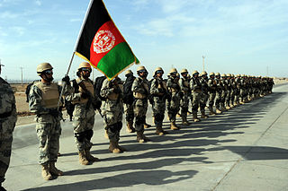
The Afghan Border Police (ABP) secure Afghanistan's 5,529 kilometres (3,436 mi) border with neighboring countries and all its international airports. It also administers immigration services such as checking documents of foreigners entering the country or deporting them. The ABP's anti-narcotic efforts are a prominent concern to the international community at present. The ABP and other divisions of the Afghan National Police jointly patrol a 55 km-wide corridor along the entirety of Afghanistan's border, particularly the longest and porous Durand Line border in the southeast with neighboring Pakistan.
Ghorband District, also known as Syagird District after its main town, is a district of Parwan Province, Afghanistan. Ghorband is located in the southern foothills of Hindu Kush and forms the western boundary of the ancient valley of Koh Daman. It is located 50 km from Kabul, the capital of Afghanistan. The capital lies at the town of Syagird. It is the largest district of the province, covering an area of 899 square kilometres with a population of 74,123 as of 2003. The Ghorband River flows through the district. It contains 58 Community Development Councils and 109 villages.
Aruj is a village in Kohistanat District in Sar-e Pol Province, in northern Afghanistan. It was formerly in Jowzjan Province. It lies just south of Negala.
Chiras is a major village and valley in Sar-e Pol Province, in northern Afghanistan. It was formerly in Jowzjan Province. The village lies north of Jawak, west of Zabrak and southeast of Khami Deh. The people of Chiras are said to be Murghabi Tajiks. The main occupation is agriculture, with most of the fertile lands lying to the west of the village and a narrow strip to the south.
Gawanak is a village in Kohistanat District in Sar-e Pol Province, in northern Afghanistan. It was formerly in Jowzjan Province. It lies southeast of Jawak.
Jarghan is a village in Kohistanat District in Sar-e Pol Province, in northern Afghanistan. It was formerly in Jowzjan Province. It lies just east of Negala.
Jawak is a village in Kohistanat District in Sar-e Pol Province, in northern Afghanistan. It was formerly in Jowzjan Province.
Negala is a village in Kohistanat District in Sar-e Pol Province, in northern Afghanistan. It was formerly in Jowzjan Province. It lies just north of Aruj.

