Afghan Turkestan, also known as Southern Turkestan, is a region in northern Afghanistan, on the border with the former Soviet republics of Turkmenistan, Uzbekistan and Tajikistan. In the 19th century, there was a province in Afghanistan named Turkestan with Mazari Sharif as provincial capital. The province incorporated the territories of the present-day provinces of Balkh, Kunduz, Jowzjan, Sar-e Pol, and Faryab. In 1890, Qataghan-Badakhshan Province was separated from Turkestan Province. It was later abolished by Emir Abdur Rahman.

The Amu Darya is a major river in Central Asia and Afghanistan. Rising in the Pamir Mountains, north of the Hindu Kush, the Amu Darya is formed by the confluence of the Vakhsh and Panj rivers, in the Tigrovaya Balka Nature Reserve on the border between Afghanistan and Tajikistan, and flows from there north-westwards into the southern remnants of the Aral Sea. In its upper course, the river forms part of Afghanistan's northern border with Tajikistan, Uzbekistan, and Turkmenistan. In ancient history, the river was regarded as the boundary of Greater Iran with "Turan", which roughly corresponded to present-day Central Asia. The Amu Darya has a flow of about 70 cubic kilometres per year on average.

Faryab is one of the thirty-four provinces of Afghanistan, which is located in the north of the country bordering neighboring Turkmenistan. It has a population of about 1,109,223, which is multi-ethnic and mostly a tribal society. The province encompasses 15 districts and over 1,000 villages. The capital of Faryab province is Maymana. It also borders Jowzjan Province, Sar-e Pol Province, Ghor Province and Badghis Province.

Türkmenabat, formerly and since medieval times Chardzhou, and in ancient times Āmul, is the second-largest city in Turkmenistan and the capital of Lebap Province. As of 2009, it had a population of approximately 254,000 people. From 1924 to 1927 it was briefly renamed Leninsk in honor of Vladimir Lenin.
The Sari Pul River is a river in northern Afghanistan originating in southwestern Sar-e Pol Province. It flows north and is joined by a major tributary from the east just south of the provincial capital, Sar-e Pol. It continues north past the town of Sar-e Pol and into Jowzjan Province. It flows past Sheberghan into the edge of the Karakum Desert where it dries up. In prehistoric times it flowed into the Amu Darya.
Kaldar is a small district in the northern part of Balkh Province, Afghanistan. The northern and the eastern border of the district is the large Amu Darya river. North of the river is Uzbekistan and east is Tajikistan. The main village, also called Kaldar, is in the northeastern part of the district, close to the river. According to the inhabitants of this village, its original name is Kakoldar.
Khamyab District is a frontier district in the province of Jowzjan in Afghanistan. It shares borders with Turkmenistan to the north and west, Khwaja Du Koh district to the south and the Mingajik and Qarqin districts to the east. As of 2006, the population is 12,400. The district center is the village of Khamyab. The Amu Darya river flows in the northern end of the district and forms part of the international border. Within the district is the westernmost point of the river on Afghan territory, and the area here is also the lowest point in the country. The riverbank in Khamyab and further downstream in Qarqin has suffered from erosion on the Afghan side for decades, with the emergence of islands and a moving borderline. The floods have damaged agricultural lands of locals.
Mardyan District is situated in the central eastern part of the Jowzjan Province, Afghanistan. It borders Mingajik District to the west, Qarqin District to north, Balkh Province and Fayzabad District to the east and Aqcha District to the south. The population is 34,200 (2006). The district center is the village of Mardyan, located in the central part of the district.
Qarqin is a town located in the northern part of Qarqin District, Jowzjan Province, Afghanistan at 37.4128°N 66.0472°E at 249 m altitude on the southern bank of the Amu Darya River, Qarqin is the center of Qarqin District.

Qalay-I-Zal District, also spelled Qala-i-Zal, is situated in the western part of Kunduz Province, northern Afghanistan. It borders Balkh Province to the west and Tajikistan to the north along the Panj, Vakhsh and Amu Darya rivers. To the east it borders Imam Sahib District and to the south Kunduz and Chahar dara districts. Qalay-I-Zal River flows through the district and divides it in two parts. The population is 60,600 (2006) - 60% Turkmen and 40% Pashtun. The district is almost a desert and only the irrigated land is arable. The agriculture and carpet weaving are the most important sources of income.
Eslām Chūngar is a small town in the province of Jowzjan, northern Afghanistan.

The dwarf sturgeon, little shovelnose sturgeon, or small Amu-Darya shovelnose sturgeon is a species of fish in the family Acipenseridae. It is found in Turkmenistan, Uzbekistan and probably in Tajikistan.

The Amu Darya sturgeon or false shovelnose sturgeon is a critically endangered species of fish in the family Acipenseridae. It is found in Turkmenistan, Uzbekistan, Tajikistan and perhaps Afghanistan. It inhabits quite shallow flowing waters that are turbid and muddy.

The Kokcha River is located in northeastern Afghanistan. A tributary of the Panj river, it flows through Badakhshan Province in the Hindu Kush. It is named after the Koksha Valley. The city of Feyzabad lies along the Kokcha. Near the village of Artin Jelow there is a bridge over the river.
Köýtendag is a city and the administrative center of Köýtendag District in Lebap Province, Turkmenistan. On 29 December 1999, by Parliamentary Resolution No. HM-61, the city and district of Çarşangy were renamed Köýtendag. On 27 July 2016, by Parliamentary Resolution No. 425-V the town of Köýtendag was upgraded in status to "city in a district".
The Kunduz River is a tributary of the Amu Darya in northern Afghanistan. It rises in Bamyan Province in the Hindu Kush, and in its upper reaches is also known as the Bamyan River or the Surkhab River. After passing through Baghlan Province and Kunduz Province, the Kunduz River merges into the Amu Darya.
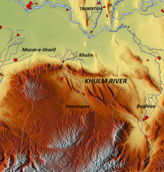
The Khulm River is a river of Northern-Central Afghanistan. In its lower course, it passes through Khulm and Haybak, today in Balkh Province. The Khulm is a tributary to the Oxus basin. Its source is located to the South of the city of Khulm. Further upstream, it passes through the city of Samangan and Samangan Province. The Khulm River forms the western border of Kunduz Province.

Aqcha or Akcha, is a city in northern Afghanistan. It is located approximately 50 kilometres (31 mi) east of Sheberghan and 100 kilometres (62 mi) west of Mazar-i-Sharif. It serves as the center of the Aqcha District of Afghanistan's Jowzjan Province. The town is situated a few kilometers north of the main Sheberghan-Mazar-i-Sharif road called Aqyol.
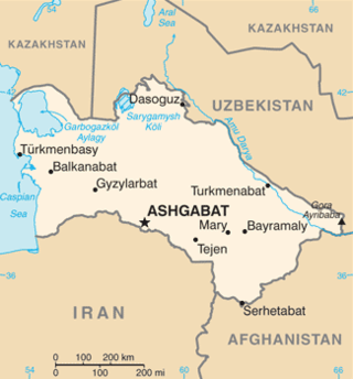
The Afghanistan–Turkmenistan border is 804 km (500 mi) in length and runs from the tripoint with Iran to the tripoint with Uzbekistan.
The Shirin Tagab River is a river in Afghanistan, and travels 320 kilometres (200 mi) before ending in an inland delta around Andkhoi. The river's watershed has 504 settlements with a population of 605972, and covers the majority of Faryab Province. Downstream, the river is brackish/saltwater. In addition, the river is a source of water-borne diseases.

