Nawzad نوزاد | |
|---|---|
District | |
 A US Marine combat engineer in Nawzad in December 2009. | |
 Nawzad | |
| Coordinates: 32°13′14″N64°34′36″E / 32.2205°N 64.5768°E | |
| Country | |
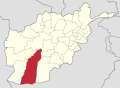
| Province | Helmand Province |
| Population (2012) [1] | |
• Total | 49,500 |
Nawzad [2] is a district in the north of Helmand Province, Afghanistan. Its population, which is 100% Pashtun, was estimated at 49,500 [1] in 2012. The district centre is the village of Nawzad; there are 14 other large villages and over 100 smaller villages. During the war in Afghanistan, the district became deadly as it was the site of the Taliban insurgents. As a result, president Obama leashed his surge in Afghanistan. During the year 2006-2014 the battle of Nawzad took place in the district. This affected the district heavily til today. As a consequense, many houses and infrastructure are still in ruins. The district is said to be dry and humid, where the levels of water are low.