
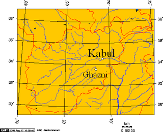
Kabul is the capital and largest city of Afghanistan. Located in the eastern half of the country, it is also a municipality, forming part of the Kabul Province; it is administratively divided into 22 municipal districts. According to 2023 estimates, the population of Kabul was 4.95 million people. In contemporary times, the city has served as Afghanistan's political, cultural, and economical center, and rapid urbanisation has made Kabul the 75th-largest city in the world and the country's primate city.

Helmand, also known as Hillmand, in ancient times, as Hermand and Hethumand, is one of the 34 provinces of Afghanistan, in the south of the country. It is the largest province by area, covering 58,584 square kilometres (20,000 sq mi) area. The province contains 18 districts, encompassing over 1,000 villages, and roughly 1,446,230 settled people. Lashkargah serves as the provincial capital. Helmand was part of the Greater Kandahar region until made into a separate province by the Afghan government in the 20th century.

Badakhshan Province is one of the 34 provinces of Afghanistan, located in the northeastern part of the country. It is bordered by Tajikistan's Gorno-Badakhshan in the north and the Pakistani regions of Lower and Upper Chitral and Gilgit-Baltistan in the southeast. It also has a 91-kilometer (57-mile) border with China in the east.
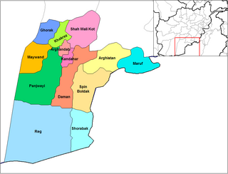
Panjwayi is a district in Kandahar Province, Afghanistan. It is located about 35 kilometres (22 mi) west of Kandahar. The district borders Helmand Province to the southwest, Maywand District to the west, Zhari District to the north, Arghandab, Kandahar and Daman districts to the east and Reg District to the south. Panjwayi was reduced in size in 2004 when Zhari District was created out of the northern part of it, on the northern side of the Arghandab River, which now forms the northern boundary.
Deh Rawood is a district in Uruzgan Province, southern Afghanistan, and the name of the town that serves as district seat. Deh Rawood lies along the Helmand River. The tribes in the district are Pashtun, dominated by the Noorzai and Populzai sub-tribes.
Farah City District is a district in Farah province, Afghanistan, containing the main city of Farah.The city of Farah has a population of 54,000. it has 6 districts and a total land area of 2,949 Hectares. The total number of dwellings in this city are 5,299.

Washir is a district in the west of Helmand Province, Afghanistan. Its population was reported in 2012 as 15,200, from the Pashtun ethnic group believed to be of Noorzai tribe. The district centre is the village of Washir. The district of Washer borders Farah province to the north and is 80 kilometres south of Lashkar Gah.

Ishkashim District is one of the 28 districts of Badakhshan province in eastern Afghanistan. The border town of Ishkashim serves as the district's capital. The population of the district is approximately 15,951 residents, majority of whom are believed to be ethnic Tajiks followed by Pashtuns, Uzbeks and others. In addition to Afghanistan's two main languages of Dari and Pashto, the language of Ishkashimi is also spoken in the district by the native people.

Yamgan is one of the 29 districts of Badakhshan Province in eastern Afghanistan. It was created in 2005 from part of the Baharak District and is home to approximately 20,000 residents, mostly Ismailis.

Kuran wa Munjan is one of the 28 districts of Badakhshan province in eastern Afghanistan. Located in the Hindu Kush mountains, the district is home to approximately 8,000 residents. The district administrative center is Kuran wa Munjan.
Ghazni District, is a district of Ghazni province, Afghanistan situated in the northeast part of the province. Capital of the district is Ghazni, which is also capital of Ghazni Province.

Reg District is located in the southern part of Kandahar Province in Afghanistan. It borders Helmand Province to the west, Panjwai and Daman districts to the north, Shorabak District to the east and Chagai District in Balochistan, Pakistan, to the south.

Khairkot District, also known as Katawaz (کټواز) or Zarghun Shar District, is a district of Paktika Province, Afghanistan. The district is within the heartland of the Sulaimankhel tribe of Ghilji Pashtuns. The district capital is Khairkot town.

Chahar Burjak District is a district of Nimruz Province in Afghanistan. At just under 22,000 square kilometres (8,500 sq mi) in area, it is the largest district in Afghanistan. The Kamal Khan Dam is located in this district.
Khash Rod District or Khashrowd is a district of Nimruz Province in Afghanistan. It had a population of 35,381 in 2004, which was 55% ethnic Pashtun, 20% Baloch, 15% Brahui and 10% Tajik. The district capital is Ghorghori.

Sancharak District or Sangcharak is a district of Sar-e Pol Province, Afghanistan. Its center is the city of Tukzar or Tokzar. Sancharak district borders Balkh Province in the east. Sancharak District's area is 1089 square kilometres.

Sozma Qala District is a district of Sar-e Pol Province, Afghanistan. Sozma Qala district is one of the 7 districts of Sarpul province, centered in Sozma Qala city in northern Afghanistan. Sozma Qala is one of the second-class districts of Sarpol province, it has an area of 787 square kilometers and is the seventh largest district of Sarpol. This district with a population of 55,993 in 2019 is the seventh most populous district of Sarpul province.[1]

The War in Afghanistan was an armed conflict from 2001 to 2021. It was the direct response to the September 11 attacks. It began when an international military coalition led by the United States launched an invasion of Afghanistan, declaring Operation Enduring Freedom as part of the earlier-declared war on terror; toppling the Taliban-ruled Islamic Emirate and establishing the Islamic Republic three years later. The Taliban and its allies were expelled from major population centers by the US-led forces, supporting the anti-Taliban Northern Alliance; however Bin Laden relocated to neighboring Pakistan. The conflict officially ended with the 2021 Taliban offensive, which overthrew the Islamic Republic, and re-established the Islamic Emirate. It was the longest war in the military history of the United States, surpassing the length of the Vietnam War (1955–1975) by approximately 6 months.

Puli Alam, also spelled Pul-i-Alam or Pol-e Alam, is a district of Logar Province, Afghanistan. The population of Puli Alam is estimated at around 108,000, which is composed of Pashtuns, Tajiks and a few others. The capital of the district is Puli Alam city, which is also the provincial capital.

The republican insurgency in Afghanistan is an ongoing armed conflict between the National Resistance Front and allied groups which fight under the banner of the Islamic Republic of Afghanistan on one side, and the Islamic Emirate of Afghanistan on the other side. On 17 August 2021, former first vice president of Afghanistan Amrullah Saleh declared himself the "caretaker" president of Afghanistan and announced the resistance. On 26 August, a brief ceasefire was declared. On 1 September, talks broke down and fighting resumed as the Taliban attacked resistance positions.

