
Kalāt or Qalāt, historically known as Qīqān, is a historic town located in Kalat District, in Pakistan's Balochistan province. The town of Kalat is the headquarter of Kalat District and is known locally as Kalat-e-Brahui and Kalat-e-Sewa.
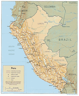
Peru is a country on the central western coast of South America facing the Pacific Ocean. It lies wholly in the Southern Hemisphere, its northernmost extreme reaching to 1.8 minutes of latitude or about 3.3 kilometres (2.1 mi) south of the equator. Peru shares land borders with Ecuador, Colombia, Brazil, Bolivia, and Chile, with its longest land border shared with Brazil.
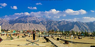
Quetta is the capital and largest city of the Pakistani province of Balochistan. It is the tenth largest city in Pakistan, with a population of over 1.6 million. It is situated in the south-west of the country, lying in a valley surrounded by mountains on all sides. Quetta is at an average elevation of 1,680 metres above sea level, making it Pakistan's only high-altitude major city. The city is known as the "Fruit Garden of Pakistan" due to the numerous fruit orchards in and around it and the large variety of fresh and dried fruits produced there.

Balkh is one of the 34 provinces of Afghanistan, located in the north of the country. It is divided into 15 districts and has a population of about 1,509,183, which is multi-ethnic and mostly a Persian-speaking society. The city of Mazar-i-Sharif serves as the capital of the province. The Mazar-i-Sharif International Airport and Camp Marmal sit on the eastern edge of Mazar-i-Sharif.

Jowzjan, sometimes spelled Jawzjan or Jozjan is one of the thirty-four provinces of Afghanistan, located in the north of the country bordering neighboring Turkmenistan. The province is divided into 11 districts and contains hundreds of villages. It has a population of about 613,481, which is multi-ethnic and mostly agriculturalists. Sheberghan is the capital of Jozjan province.

Sar-e Pol, also spelled Sari Pul, is one of the thirty-four provinces of Afghanistan, located in the north of the country. It borders Ghor and Bamyan to the south, Samangan to the east, Balkh and Jowzjan to the north, and Faryab to the west. The province is divided into 7 districts and contains 896 villages. It has a population of about 632,000, which is multi-ethnic and mostly a tribal society. The province was created in 1988, with the support of northern Afghan politician Sayed Nasim Mihanparast. The city of Sar-e Pol serves as the provincial capital.

Paghman (Dari/Pashto:پغمان) is a town in the hills near Afghanistan's capital of Kabul. It is the seat of the Paghman District which has a population of about 120,000, mainly Pashtuns and Tajiks. The gardens of Paghman are a major tourist attraction, and why the city is also known as the garden capital of Afghanistan. The neighboring town of Qargha is to the southeast, which can be reached by several roads.
Farah is the capital and largest city of Farah Province in western Afghanistan. It is located on the Farah River, close to the border with Iran. It is one of the largest cities of western Afghanistan in terms of population, with about 1.5 million people living in its urban area.

Musakhail (Urdu: ضلع موسیخیل) is a district in the northeast of the Balochistan province of Pakistan. It became a separate district in 1992, prior to which it was a tehsil within Loralai District. Musakhail District is now part of Loralai Division, which was created after splitting Zhob Division.

Hazara is a region in northern Pakistan, falling administratively within Hazara Division of the Khyber Pakhtunkhwa province. It is dominated mainly by the Hindko speaking Hazarewal people, who make up the many native ethnic groups of the region and often called the "Hazarewal".

Charikar, officially renamed to Imam Abu Hanifa or Imam Azam, is the main town of the Koh Daman Valley. It is the capital of Charikar District, and the capital of Parwan Province in northern Afghanistan. It has a population of around 171,200, which is majority Tajik populated. The town was officially renamed in December 2022 by the Taliban to honor the Sunni Muslim theologian and jurist Abu Hanifa, who is also sometimes called Imam Azam and was the founder of the Hanafi school of Islamic law.

Grishk, also spelled Gereshk, is the new name of Zamindawar which is named after the invasion the region by Nader Afshar army and given to Ghilji tribe in 18th century. Grishk a town in Grishk District of Helmand province, geographically located along the Helmand River in Afghanistan, some 120 km (75 mi) northwest of Kandahar, at 817 metres (2,680 ft) altitude. Upstream lies the Kajaki Dam which diverts water to the Boghra Irrigation Canal, an essential infrastructure for the region's crops. Grishk Dam is also nearby. Grishk was originally built around a fort on the east bank of the river but was later rebuilt on the west. The fort was twice captured by the British: first in the First Anglo-Afghan War and again in 1879. In both cases the fort was later abandoned. Grishk has a population of about 48,546 and has a hospital and a school of engineering which was built back in 1957.

Kajaki is a village in southern Afghanistan, and is split between two townsteads, Kajaki 'Olya, and Kajaki Sofla. It is the district centre of Kajaki District in Helmand Province. North east of the village is an important hydro power station for electricity and irrigation projects, the Kajaki Dam. The village itself hugs the east side of the Helmand River, right after it makes its first turn south, one km out from the dam. Kajaki is bordered by the town Payson to its west, Tangeye, an abandoned bazaar to its north, Shabez Kheyl, and Kanzi to its north west, all across the Helmand. Kajaki serves as the northern terminus of Route 611.
Shīnḍanḍ is a town and the center of the Shindand District, Herat Province, Afghanistan. It is located at 33.3036°N 62.14°E at 1,066 m altitude on the Harut River. The Shindand Air Base is located about 15 miles northeast of the town.

Puli Alam, also spelled Pul-i-Alam or Pol-e Alam, is the provincial capital of Logar Province, Afghanistan as well as of Puli Alam District. The population of the district is estimated to be around 108,000, and is composed of ethnic Pashtuns and Tajiks. The city of Puli Alam itself had a population of 22,914 in 2015. it has 4 districts and a total land area of 3,752 hectares. The total number of dwellings in the city is 2,546.

Hisor or Hisar is a city in western Tajikistan, about 15 km west of Dushanbe. The city was the seat of the former Hisar District, and is part of the Districts of Republican Subordination. It lies at an altitude of 799–824 m, surrounded by high mountains. The river Khanaka, a tributary to the Kofarnihon, flows through the town. Its population is estimated at 29,100 for the city proper and 308,100 for the city with the outlying communities (2020). As of 2002, its population was composed 81.6% of Tajiks, 12.3% Uzbeks, 3.6% Russians, and 2.5% others.

Parun, also called Prasûn and Prasungul, is a small town and administrative center of Nuristan Province and its Parun District in Afghanistan.
Tukzar is a town in Sancharak district of Sar-e Pol Province, Afghanistan. The town is the administrative centre of Sancharak district.
Zabrak is a village in Balkhab District, Sar-e Pol Province, in northern Afghanistan. It lies north of Gawanak, south of Alar, and west of Jawak and Chiras. The nearest major towns are Mazar-i-Sharif to the northeast and Meymaneh to the northwest.
Ghorghori city or Ghurghuri, also called Ghor Ghori is a town and capital of Khash Rod District of Nimruz Province, Afghanistan.

