
In geography, the temperate climates of Earth occur in the middle latitudes, which span between the tropics and the polar regions of Earth. These zones generally have wider temperature ranges throughout the year and more distinct seasonal changes compared to tropical climates, where such variations are often small; they usually differ only in the amount of precipitation.

Gokase is a town in Nishiusuki District, Miyazaki Prefecture, Japan. As of 30 September 2023, the town has an estimated population of 3400 in 1504 households and a population density of 20 persons per km2. The total area of the town is 171.73 square kilometres (66.31 sq mi).
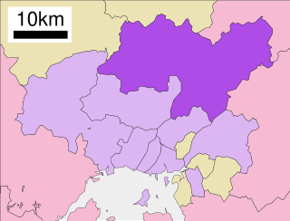
Asakita-ku (安佐北区) is one of the eight wards of the city of Hiroshima.
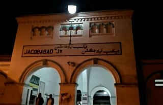
Jacobabad is a city in Sindh, Pakistan, serving as both the capital city of Jacobabad District and the administrative centre of Jacobabad Taluka, an administrative subdivision of the district. The city itself is subdivided into eight Union Councils. Sitting far to the northwest of the province, near the provincial boundaries of Sindh and Balochistan, Jacobabad became a city on the site of an existing village (Khangarh), and is crossed by the Pakistan Railways and many main roads of the province. It is the 43rd most populous city in Pakistan.

Grishk, also spelled Gereshk, is the new name of Zamindawar which is named after the invasion the region by Nader Afshar army and given to Ghilji tribe in 18th century. Grishk a town in Grishk District of Helmand province, geographically located along the Helmand River in Afghanistan, some 120 km (75 mi) northwest of Kandahar, at 817 metres (2,680 ft) altitude. Upstream lies the Kajaki Dam which diverts water to the Boghra Irrigation Canal, an essential infrastructure for the region's crops. Grishk Dam is also nearby. Grishk was originally built around a fort on the east bank of the river but was later rebuilt on the west. The fort was twice captured by the British: first in the First Anglo-Afghan War and again in 1879. In both cases the fort was later abandoned. Grishk has a population of about 48,546 and has a hospital and a school of engineering which was built back in 1957.

Kishim District is one of the 29 districts of Badakhshan province in eastern Afghanistan.The district capital is Mashhad. The district is located in the Keshem Valley, a primarily rural area on the western edge of the province, and is home to approximately 89,833 residents, making it the second most populous district of the province.
Andarab is district located in the southern part of Baghlan Province, Afghanistan. The estimated population of Andarab in 2004 was roughly 120,642. The district centre is the village of Andarab, which is named after the Andarab valley in which it is located.
Garmsir is the center of Garmsir District in Helmand Province, Afghanistan. It is situated on the eastern bank of the Helmand River on 31.1167°N 64.2000°E at 714 m altitude and 63 km southwest of Lashkargah. The major road at Garmsir is Route 605. The hospital is called Hazar Juft Comprehensive Health Clinic.
Obe is a town and the administrative center of Obe District, Herat Province, Afghanistan. It is located at 34.3697°N 63.1764°E at 1277 m altitude in the valley of the Hari River, northeast of Herat.
Bagrami is a village situated in the eastern fringes of Kabul at 34.4911°N 69.2756°E and 1797 m altitude, part of municipal District 12 and partly in District 22. The population is 31,680. Downtown Kabul can be reached in 30 minutes. The Bagrami Industrial Park is one of the major projects for the economy of the region. In 2010, the town also harboured a shanty town of mud-built huts from refugees escaping the violence of the Taliban insurgency in the southern provinces of Afghanistan.

Puli Alam, also spelled Pul-i-Alam or Pol-e Alam, is the provincial capital of Logar Province, Afghanistan as well as of Puli Alam District. The population of the district is estimated to be around 108,000, and is composed of ethnic Pashtuns and Tajiks. The city of Puli Alam itself had a population of 22,914 in 2015. it has 4 districts and a total land area of 3,752 hectares. The total number of dwellings in the city is 2,546.

Sancharak District or Sangcharak is a district of Sar-e Pol Province, Afghanistan. Its center is the city of Tukzar or Tokzar. Sancharak district borders Balkh Province in the east. Sancharak District's area is 1089 square kilometres.

Kurān wa Munjān, also spelled Kiran wa Munjan or Koran va Monjan, is a village in Badakhshan Province in north-eastern Afghanistan. It is the capital of Kuran wa Munjan District.

Kosovo is a relatively small country. Because of the climatic position and complicated structure of the relief it has a variety of climate systems.
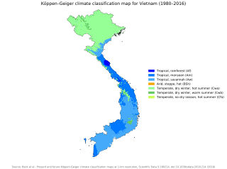
Vietnam has a monsoon-influenced climate typical of that of mainland Southeast Asia. The diverse topography, long latitude, and influences from the South China Sea lead to climatic conditions varying significantly between regions. The northern region experiences a monsoonal and temperate climate (Cfa) with four distinct seasons with winters typically dry and summers ranging from hot to mild. In southern and central areas, the climate is tropical monsoon (Aw) with only two seasons. In addition, a temperate climate exists in mountainous areas, which are found in Sa Pa and Da Lat, while a more continental climate exists in Lai Châu Province and Sơn La Province.
Zaranj District is a district of Nimruz Province, Afghanistan, containing the provincial capital city of Zaranj.
Waygal District is a district of Nuristan Province in eastern Afghanistan. It has nine major villages in the valley as following by area and population, Waygal, Zanchgal, Nishigram, Ameshdesh, Akun, Kegal, Muldesh, Jamach, and Want. The local Kalasha people speak the Waigali language, a Nuristani language. Pashto and Dari are also widely understood and used as official languages.
Chiras is a major village and valley in Sar-e Pol Province, in northern Afghanistan. It was formerly in Jowzjan Province. The village lies north of Jawak, west of Zabrak and southeast of Khami Deh. The people of Chiras are said to be Murghabi Tajiks. The main occupation is agriculture, with most of the fertile lands lying to the west of the village and a narrow strip to the south.
Khandkhel or Khand Khil is a town in the Said Karam District of Paktia Province, Afghanistan. It is located 25 km to the northeast of Gardez, the capital of Paktia, and is 40 km to the southwest of Aryob.
Ghorghori city or Ghurghuri, also called Ghor Ghori is a town and capital of Khash Rod District of Nimruz Province, Afghanistan.

