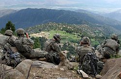
Kunar is one of the 34 provinces of Afghanistan, located in the northeastern part of the country. Its capital is Asadabad. Its population is estimated to be 508,224. Kunar's major political groups include Wahhabis or Ahl-e- Hadith, Nazhat-e Hambastagi Milli, Hezb-e Afghanistan Naween, Hezb-e Islami Gulbuddin.

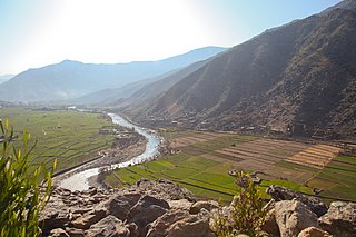
The Chitral River, also known in Afghanistan as the Kunar River, is a 480 kilometres (300 mi) long river in northern Pakistan and eastern Afghanistan. It originates from the Chiantar glacier, located at the border of Gilgit Baltistan and Chitral which falls within the Khyber Pakhtunkhwa province of Pakistan. At Arandu it enters into Afghanistan, where it is named as the Kunar River. It later merges with Kabul river in the Nangahar Province of Afghanistan. The river system is fed by melting glaciers and snow of the Hindu Kush mountains. The Chitral River serves as a major a tributary of the Kabul river, which is in turn a tributary of the Indus River.

Goshta District is located in the northeast of Nangarhar Province, Afghanistan and borders Durand Line between Afghanistan and Pakistan. The district's population is Pashtun and was estimated at 160,000 in 2002, of whom 30,000 were children under 12. The district is within the heartland of the Mohmand tribe of Pashtuns. The district centre is the village of Goshta, on the Kabul River.
Surkh-Rōd.(Pashto/Persian: سرخرود/ سره رود), also spelled as Surkh-Rūd or Sorkh-Rūd, also called Sra-rod or Sra- road, is a district in the north of Nangarhar Province, Afghanistan. The district centre is the town of Sultanpur. It is well known to locals because of its abundance of fertile land; however, it is currently facing a lack of water.

Asadabad district is one of 15 districts in the Kunar Province of Afghanistan. It includes the city of Asadabad - the district center, close the Kunar River. It is situated in the central part of the province. It has 12 big and small villages, which are surrounded by mountains so there is not enough land for farming.

Marawara District is one of the 15 districts in Kunar Province, Afghanistan. It borders Sirkanay District to the west, Asadabad District to the north-west, Dangam District to the north-east and the Durand Line to the south. Marawara's population is not exactly known but government figures estimate it to be around 22,270 people, all of them being ethnic Pashtuns. Marawara village is the center of the district and is located in its westernmost part.
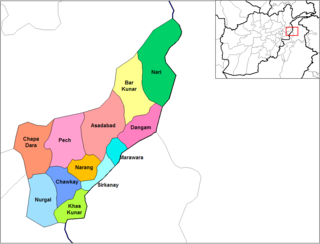
Dangam District is situated in the eastern end of Kunar Province in Afghanistan. It borders Marawara district to the southwest, Asadabad district to the west, Bar Kunar district to the north, Nari district to the northeast and Khyber Pakhtunkhwa in Pakistan to the east. The district is mountainous and stunning but also poor.
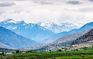
Nari (Naray) District is a mountainous district in the eastern part of Kunar Province in Afghanistan. It borders Bar Kunar District to the west, Nuristan Province to the north, Khyber Pakhtunkhwa to the east and Dangam district to the south. The population was reported in 2006 as 24,500 of which around 60% is ethnic Gawar (Kohistani). The district center is the village of Nari (Naray)35.2103°N 71.5250°E at 1153 m altitude in a river valley. The arable land is not enough. The residents usually collect wood and beans and sell them.
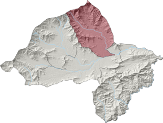
Ghaziabad District is in the northern part of Kunar Province, Afghanistan. It was created in 2004 from the northern part of Bar Kunar District. It was named after the Khan of Ghaziabad, Amir Muhammad Ghazi Khan Shaheed. Its population is 7,500 (2004).
Watapur District is situated in the central part of Kunar Province in Afghanistan. It was split from Asadabad district. The district is mountainous with 60 large and small villages. The population is around 60,000. Degan, Safi, Rangakhel, Sharbekhel, Nanekhel, Doshakhel, Kohestani, Saidan are the few tribes living in this beautiful place. Watapur District has a high school located in south part of the district. The villages are located in the valleys or in the high mountains, with difficult or no road access to the center - Asadabad, and it takes one day to reach some of them. There was a medical clinic north of Qatar Kala, built by ISAF, until it was destroyed by local militants.

Narang, Kunar, Afghanistan نرنګ in Pashto and Persian is situated in the central part of Kunar Province, Afghanistan south of Asadabad. It is surrounded by high mountains and the Kunar River. The population is 36,700 (2014). The district center is the village of Kuz Narang at 742 m altitude. It is the kunar 2nd largest district regarding Agriculture Land. The irrigation system is under rehabilitation. The land is in much good condition and fertile. The irrigation system is almost the best in Kunar province. About 75% of the people are educated. The famous villages are: 1: Bar-Narhang 2: Kotkay 3: Badel dara 4: kuz-Narhang 5: Lamatak 6: dandona 7: Char qala 8: kodo ; etc.

Nurgal District is in the western part of Kunar Province in Afghanistan, 45 kilometres (28 mi) west of the town of Asadabad, near the city of Jalalabad. It borders Nangarhar Province to the west and south, Chapa Dara district to the north and Chawkay and Khas Kunar districts to the east.
Nurgal or Nur Gal is the center of Nurgal district, in the Kunar Province of Afghanistan. It is located at 34.6108°N 70.7569°E at 635 m altitude in the valley of the Kunar River.
Khas Kunar or Sarkani(sarkano) District is the largest district in the Kunar Province, Afghanistan. It is situated in the southern part of the province and borders Nangarhar Province to the south and Pakistan to the east. The Kunar River passes north through the district and irrigates the surrounding land. The population was estimated to be 31,000 in 2006. The district center, Khas Kunar village is located at 34.6458°N 70.9008°E at 749 m altitude. Most of the houses were destroyed during the wars and droughts also have seriously affected the lands all around the Kunar River.

Sirkanay District is situated in the central part of Kunar Province, Afghanistan. It borders Pakistan to the south. The population is 39,292 (2019). The district administrative center is the village of Serkanay at 775 m altitude. To the north the district borders the Kunar River, which irrigates the small part of arable land. Drought is the major problem of the people. The majority of the houses (70%) were destroyed during the wars. Many young men live and work in Pakistan.
Mangwal is a village in Khas Kunar District, Kunar Province, Afghanistan. It is located at 34°36'7N 70°49'41E with an altitude of 742 metres (2437 feet).

Dara-I-Pech District is located in western-central Kunar Province, Afghanistan, 30 km west of Asadabad. The population was 48,400 in 2006. The district is governed from Mano Gai. The governor is Mohammad Rahkman.
On 23 February 2014, Taliban insurgents supported by Afghan insiders raided two ANA checkpoints located outside the city of Asadabad in the Ghaziabad District of Kunar province, Eastern Afghanistan. The raid marked the deadliest attack against Afghan security forces since 2010.
Salarzai Tehsil is an administrative subdivision (tehsil) of Bajaur District in Khyber Pakhtunkhwa Province, Pakistan. Salarzai is the third largest of Bajaur District's seven tehsils.

NawagaiTehsil is an administrative subdivision (tehsil) of Bajaur District in Khyber Pakhtunkhwa Province, Pakistan. Nawagai is the fourth largest of Bajaur District's seven tehsils.