
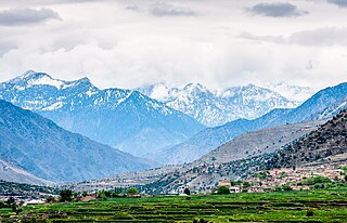
Asadabad or Asad Abad is the capital city of Kunar Province in Afghanistan. It is located in the eastern portion of the country adjacent to Pakistan. The city is located within a valley at the confluence of the Pech River and Kunar River between two mountain ridgelines running along both sides of the valley from Northeast to Southwest.
Kunar is one of the 34 provinces of Afghanistan, located in the northeastern part of the country. Its capital is Asadabad. Its population is estimated to be 508,224.

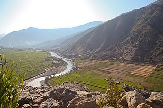
The Kūnaṛ River, also known in its upper reaches as the Mastuj, Chitral, or Kama River, is about 480 kilometres (300 mi) long, located in eastern Afghanistan and northern Pakistan. It emerges just south of the Broghil Pass, in the upper part of Chitral District of Khyber Pakhtunkhwa near the Afghan border. The river system is fed by melting glaciers and snow of the Hindu Kush mountains. The Kunar River is a tributary of the Kabul River, which is in turn a tributary of the Indus River.

The Pech River is located in eastern Afghanistan.

Goshta District is located in the northeast of Nangarhar Province, Afghanistan and borders Durand Line between Afghanistan and Pakistan. The district's population is Pashtun and was estimated at 160,000 in 2002, of whom 30,000 were children under 12. The district is within the heartland of the Mohmand tribe of Pashtuns. The district centre is the village of Goshta, on the Kabul River.

Asadabad district is one of 15 districts in the Kunar Province of Afghanistan. It includes the city of Asadabad - the district center, close the Kunar River. It is situated in the central part of the province. It has 12 big and small villages, which are surrounded by mountains so there is not enough land for farming.
Nari (Naray) District is a mountainous district in the eastern part of Kunar Province in Afghanistan. It borders Bar Kunar District to the west, Nuristan Province to the north, Khyber Pakhtunkhwa to the east and Dangam district to the south. The population was reported in 2006 as 24,500 of which around 60% is ethnic Pashtun. The district center is the village of Nari (Naray)35.2103°N 71.5250°E at 1153 m altitude in a river valley. The arable land is not enough. The residents usually collect wood and beans and sell them.
Shegal District was split from Chapa Dara District in Kunar Province, Afghanistan and the population is 13,351 (2019). Waheedullah Sabawoon and late Kashmir Khan, two of the famous politicians of Afghanistan, belonging to this district. Wall nut, Malt, date plum and plum are the famous fruits while, rice, wheat, sugarcane, corns and cotton are the main crops cultivated in the district. The Kunar river is separating Shugal from Shultan while both areas are connected by Shultan bridge. Since last couple of years, the Shultan separated and has become a district. It has a long border with neighbor Pakistan. Villages in Shegal district include Dag-e-Ser, Shangurgul, Lachay, Monay, Helalzo, Naret, Chaqore, and more. In Shegal District 80% of males and 30% of females are educated.
Watapur District is situated in the central part of Kunar Province in Afghanistan. It was split from Asadabad district. The district is mountainous with 60 large and small villages. The population is around 24,300. The villages are located in the valleys or in the high mountains, with difficult or no road access to the center - Asadabad, and it takes one day to reach some of them. There was a medical clinic north of Qatar Kala, built by ISAF, until it was destroyed by local militants.
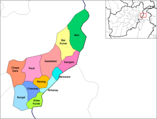
Chapa Dara District is situated in the western part of Kunar Province, Afghanistan and borders Nuristan Province. The population is 27,500 (2006). The district consists of a mountainous terrain. The capital of the district is Chapa Dara.

Narang, Kunar, Afghanistan نرنګ in Pashto and Persian is situated in the central part of Kunar Province, Afghanistan south of Asadabad. It is surrounded by high mountains and the Kunar River. The population is 36,700 (2014). The district center is the village of Kuz Narang at 742 m altitude. It is the kunar 2nd largest district regarding Agriculture Land. The irrigation system is under rehabilitation. The land is in much good condition and fertile. The irrigation system is almost the best in Kunar province. About 75% of the people are educated. The famous villages are: 1: Bar-Narhang 2: Kotkay 3: Badel dara 4: kuz-Narhang 5: Lamatak 6: dandona 7: Char qala 8: kodo ; etc.

Chawkay District is situated in the central part of Kunar Province, Afghanistan. The population was reported in 2006 as 31,600. The district center is the village of Chawkay at 726 m altitude in the valley of the Kunar river. Roughly 80% of the houses in the district were destroyed during the wars.

Nurgal District is in the western part of Kunar Province in Afghanistan, 45 kilometres (28 mi) west of the town of Asadabad, near the city of Jalalabad. It borders Nangarhar Province to the west and south, Chapa Dara district to the north and Chawkay and Khas Kunar districts to the east.

Sirkanay District is situated in the central part of Kunar Province, Afghanistan. It borders Pakistan to the south. The population is 39,292 (2019). The district administrative center is the village of Serkanay at 775 m altitude. To the north the district borders the Kunar River, which irrigates the small part of arable land. Drought is the major problem of the people. The majority of the houses (70%) were destroyed during the wars. Many young men live and work in Pakistan.

Dara-I-Pech District is located in western-central Kunar Province, Afghanistan, 30 km west of Asadabad. The population was 48,400 in 2006. The district is governed from Mano Gai. The governor is Mohammad Rahkman.
Operation Bulldog Bite was a joint US and Afghan counter-insurgent mission in Kunar province, Afghanistan, against Taliban forces that was conducted in November 2010. The operation targeted Taliban havens in the villages of the Watapur District, which lies in the eastern region of the Pech River Valley. The region served as a transit area for Taliban and al Qaeda fighters entering from Pakistan, and is just five miles from the Korangal Valley, an area where US forces had previously shut down combat operations. In 2009, US commanders stated that the valley was strategically insignificant due to its remote location, but the Taliban and al Qaeda would later use the region to launch attacks into neighboring Afghan provinces.

Mano Gai or Manogai is a small town and capital of Dara-I-Pech District in Kunar Province, in eastern Afghanistan. It lies on the confluence of several rivers.

