Related Research Articles
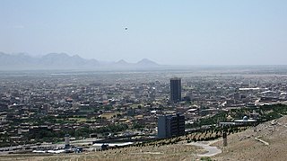
Herāt is an oasis city and the third-largest city of Afghanistan. In 2020, it had an estimated population of 574,276, and serves as the capital of Herat Province, situated south of the Paropamisus Mountains in the fertile valley of the Hari River in the western part of the country. An ancient civilization on the Silk Road between the Middle East, Central and South Asia, it serves as a regional hub in the country's west.

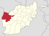
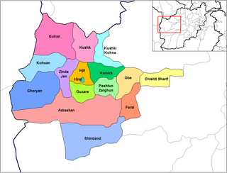
Herat is one of the thirty-four provinces of Afghanistan, located in the north-western part of the country. Together with Badghis, Farah, and Ghor provinces, it makes up the north-western region of Afghanistan. Its primary city and administrative capital is Herat City. The province of Herat is divided into about 17 districts and contains over 2,000 villages. It has a population of about 3,780,000, making it the second most populated province in Afghanistan behind Kabul Province. The population is multi-ethnic but largely Persian-speaking. Herat dates back to the Avestan times and was traditionally known for its wine. The city has a number of historic sites, including the Herat Citadel and the Musalla Complex. During the Middle Ages Herat became one of the important cities of Khorasan, as it was known as the Pearl of Khorasan.
Adraskan is a district in the central part of Herat Province in Afghanistan. It is bordered to the west by Iran, to the north by Ghoryan District, Zinda Jan District, Guzara District, Pashtun Zarghun District and Obe District, to the east by Farsi District and to the south by Sabzwar District.

Chishti Sharif District, also known as Chisht District, is the most easterly district in Herat Province, Afghanistan, situated along the Hari River and one of its northern tributaries. It borders with Obe District to the west, Badghis Province to the north and Ghor Province to the east and south. The population was estimated at 23,100 in 2012. The district administrative center is the village of Chishti Sharif.
Farsi is a district the west of Herat Province, Afghanistan. It borders on Obe District to the north, Adraskan District to the west, Shindand District to the south and Ghor Province to the south and east. The population was estimated at 29,800 in 2012. The district center is the village of Farsi.
Ghurian is a city and the administrative center of Ghurian District in Herat Province, Afghanistan. It is 790 m high with a population of more than 54,000 people. It is situated south of the Hari River along the Mashhad-Herat highway at 34.34°N 61.47°E. There is a local TV station and a health center. Ghurian is close to the old city of Pushang. In 2020 Ghurian was connected by rail to Khaf in Iran.
Guzara (Gozareh) is a village and the center of Guzara District in Herat Province, Afghanistan on 34.2167°N 62.2167°E at 992 m altitude. The Herat Airfield is very close to the village to the east.
Injil is a village and the center of the Injil District in Herat Province, Afghanistan. It is located at 34.3°N 62.25°E at 950m altitude a few miles southeast of Herat.
Kushki Kuhna is a town and the center of Kushki Kuhna District, Herat Province, Afghanistan. It is located at 34.8714°N 62.5483°E at 1125 m altitude and is 170 km northeast of Herat.
Obe is a district in the northeast of Herat Province, Afghanistan. It borders on the north with Badghis Province, on the east with Chishti sharif District, on the southeast with Farsi District, on the south with Adraskan District, and on the west with Pashtun Zarghun and Karukh districts.
Shinḍanḍ District is located in the southern part of Herat Province in Afghanistan, bordering Adraskan District to the north, Ghor Province to the east and Farah Province to the south and west. It is one of the 16 districts of Herat Province. The name Shindand is Pashto and relates to lush green farming area. In Persian language it translates to Sabzwār.
Shīnḍanḍ is a town and the center of the Shindand District, Herat Province, Afghanistan. It is located at 33.3036°N 62.14°E at 1,066 m altitude on the Harut River. The Shindand Air Base is located about 15 miles northeast of the town.
Shibirghan District (Sheberghan) is situated in the southern part of Jowzjan Province in Afghanistan. It borders Faryab Province to the west, Khwaja du koh District to the north, Aqcha District to the east and Sar-e Pol Province. The population is 188,808 (2019). The center is the provincial capital Sheberghan. There are main roads from the district center towards Herat, Kabul, Andkhoy and Mazari Sharif. Sheberghan airfield is situated between Sheberghan and Aqchah.

Kohband District is situated in the northwestern part of Kapisa Province, Afghanistan. It borders Kohistan District to the west, Parvan Province to the north, Nijrab District to the east and Mahmud Raqi District to the south. The population is 26,133 (2019). The district center is Hajjikheyl located in the western part of the district. The people mostly speak Pashayi language.

Marawara District is one of the 15 districts in Kunar Province, Afghanistan. It borders Sirkanay District to the west, Asadabad District to the north-west, Dangam District to the north-east and the Durand Line to the south. Marawara's population is not exactly known but government figures estimate it to be around 22,270 people, all of them being ethnic Pashtuns. Marawara village is the center of the district and is located in its westernmost part.
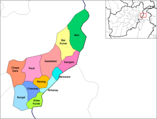
Dangam District is situated in the eastern end of Kunar Province in Afghanistan. It borders Marawara district to the southwest, Asadabad district to the west, Bar Kunar district to the north, Nari district to the northeast and Khyber Pakhtunkhwa in Pakistan to the east. The district is mountainous and stunning but also poor.

Sirkanay District is situated in the central part of Kunar Province, Afghanistan. It borders Pakistan to the south. The population is 39,292 (2019). The district administrative center is the village of Serkanay at 775 m altitude. To the north the district borders the Kunar River, which irrigates the small part of arable land. Drought is the major problem of the people. The majority of the houses (70%) were destroyed during the wars. Many young men live and work in Pakistan.

Bādghīs is one of the thirty-four provinces of Afghanistan, located in the northwest of the country, on the border with Turkmenistan. It is considered to be one of the country's most underdeveloped provinces, with the highest poverty rate. The capital is Qala e Naw, while the most populous city and the district are Bala Murghab. The ruins of the medieval city of Marw al-Rudh, the historical capital of the medieval region of Gharjistan, are located in the province near the modern city of Bala Murghab.
Yusufkhel or Yosuf Khel is a district of Paktika Province, Afghanistan. The estimated population in 2019 was 28,691.
References
- ↑ "Estimated Population of Afghanistan 2019-20" (PDF). Central Statistics Organization. 18 November 2019. p. 43. Archived from the original (PDF) on 9 June 2020. Retrieved 6 April 2020.