Nani نانی | |
|---|---|
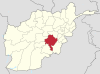
 Nani Location within Afghanistan | |
| Coordinates: 33°23′48″N68°21′14″E / 33.39667°N 68.35389°E | |
| Country | |
| Province | Ghazni Province |

Nani is a town in Ghazni Province, Afghanistan. It lies along highway A01. [1]
Nani نانی | |
|---|---|
| Nani Location within Afghanistan | |
| Coordinates: 33°23′48″N68°21′14″E / 33.39667°N 68.35389°E | |
| Country | |
| Province | Ghazni Province |
Nani is a town in Ghazni Province, Afghanistan. It lies along highway A01. [1]

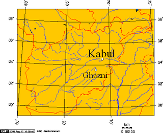
Ghazni, historically known as Ghaznain (غزنين) or Ghazna (غزنه), also transliterated as Ghuznee, and anciently known as Alexandria in Opiana, is a city in southeastern Afghanistan with a population of around 190,000 people. The city is strategically located along Highway 1, which has served as the main road between Kabul and Kandahar for thousands of years. Situated on a plateau at 2,219 metres (7,280 ft) above sea level, the city is 150 kilometres (93 mi) south of Kabul and is the capital of Ghazni Province. The name Ghazni drives from the Persian word "ganj", meaning ‘treasure’.

Afghanistan is divided into 34 provinces. The provinces of Afghanistan are the primary administrative divisions. Each province encompasses a number of districts or usually over 1,000 villages.

Ghazni is one of the 34 provinces of Afghanistan, located in southeastern Afghanistan. The province contains 19 districts, encompassing over a thousand villages and roughly 1.3 million people, making it the 5th most populous province. The city of Ghazni serves as the capital. It lies on the important Kabul–Kandahar Highway, and has historically functioned as an important trade center. The Ghazni Airport is located next to the city of Ghazni and provides limited domestic flights to Afghanistan's capital, Kabul.

Nawur is one of the districts of Afghanistan, which is located in the northern part of Ghazni Province. With an area of approximately 5,234 km2 (2,021 sq mi), Nawur is the largest district of Ghazni province. Its population was estimated at 91,778 in 2002. Nawur's inhabitants are ethnic Hazaras followed by Kochis. The Jikhai River originates here.
Malistan or Malestan, is a district in Ghazni province, Afghanistan. Its population, which is 100% Hazara, was estimated at 350,000 in 2009. The district capital is Mir Adina.
Nawa is a large district in the far south of Ghazni Province, Afghanistan. It is 100 km south from Ghazni in a mountainous region. The salt lake Ab-i Istada is located in the northern part of the district. Nawa's population was estimated at 29,054 in 2002, of whom around 45% were children under 12. The district center is the village of Nawa. Military operations in the district were featured in articles in the Washington Post and the New York Times in October 2009. The district was controlled by the Taliban until 17 July 2017.
Muqur is a district in the southwest of Ghazni province, Afghanistan. Its population was estimated at 70,900 in 2002, of whom 19,538 were children under 12.

Qarabagh or Qara Bagh, is a district in Ghazni province, 56 km to the south-west of Ghazni city in eastern Afghanistan. The 1,800 km2 area is one of the most populated at 109,000; some reports count more than 218,000. The ethnic composition of the district includes Hazaras and Pashtuns. The landscape varies in different parts of the district - deserts in the southwest, plains in the southeast and mountains in the north. The district is seriously affected by drought, especially farming and animal husbandry. Health and education need serious improvement.

The Giro District is located within southeastern Ghazni province in Afghanistan, 50 km South East of Ghazni city. The district is a wide plain with scattered low mountains. More than 40 000 residents are estimated, according to 2002 year's data. The district is within the heartland of the Tarakai tribe of Ghilji Pashtuns. The district center is Pana.
Andar is one of the eastern districts of Ghazni Province in Afghanistan. The population has been estimated at 88,300, all Pashtun. The district center is Miray while the other main town is Andar. The district is named after the Andar Ghilji tribe of the Pashtuns. The district also contains the town of Sardeh Band on its edge near the border with Paktika Province.
Deh Yak is a rural district in the eastern part of Ghazni Province, Afghanistan, 30 km east from the city of Ghazni. The district has an area of 715 km2, containing 66 villages and a population of about 44,386. Ramak serves as the district's headquarters.
Zana Khan district is a mountainous district in Ghazni province, Afghanistan with more than 12,000 people living there. The district center is Dado.
Ghazni District, is a district of Ghazni province, Afghanistan situated in the northeast part of the province. Capital of the district is Ghazni, which is also capital of Ghazni Province.
Jaghatu is a district in Maidan Wardak province, Afghanistan, 20 km northwest of Ghazni. According to 2019 data, the population is 50,792. The district is within the heartland of the Wardak tribe of Pashtuns. Agriculture is the main source of income. The popular apples in Afghanistan is from this district. Drought has become a serious problem in the whole province. Health and education services are lacking although most of the people in this area have attempted to create schools and for students to attend with their own efforts.
Waghaz is a district in Ghazni province, Afghanistan. It was formed in 2005 from part of Muqur District, and has a population estimated at 27,900.

The Sultan Mahmud Dam or Band-e Sultan is a dam located on the Ghazni River in the Jaghatu District of Ghazni Province in Afghanistan. As of April 2013, the dam is just used for irrigating 15,000 hectares of land. It is believed to have the potential to meet electricity needs of 50,000 families. The dam has importance for residents of Ghazni and neighboring Maidan Wardak province. It is believed to be first built during the Ghaznavids era in the 10th century, in memory of Sultan Mahmud of Ghazni.
Gulbawri is a residential area in Afghanistan, located in Jaghatu District of Ghazni Province.

The Ghazni offensive began on 10 August 2018, when Taliban fighters launched an assault on the city of Ghazni, Afghanistan's sixth largest city and one which has been culturally and strategically important for much of the country's history. The attack resulted in the deaths of hundreds of insurgents, soldiers, police, and civilians. The city also sustained large-scale property damage. The battle, occurring only weeks before Afghanistan's 2018 parliamentary election, was the largest since a three-day truce in June had raised hopes of peace talks.
On 17 October 2017, insurgents attacked Gardez, Paktia Province and Ghazni Province in Afghanistan.
| | This Ghazni Province, Afghanistan location article is a stub. You can help Wikipedia by expanding it. |