Augrabies Falls National Park

Last updated

Augrabies Falls National Park
Augrabie, Waterfalls, South Africa.jpg
Augrabies Falls National Park
Location of the park
Location Northern Cape, South Africa
Nearest city Upington
Coordinates 28°35′28″S20°20′18″E / 28.59111°S 20.33833°E / -28.59111; 20.33833
Area820 km2 (320 sq mi)
Established1966;57 years ago (1966)
Governing body South African National Parks
www.sanparks.org/parks/augrabies/
South Africa relief location map.svg
Red pog.svg
Augrabies Falls National Park (South Africa)
South Africa Northern Cape relief location map.svg
Red pog.svg
Augrabies Falls National Park (Northern Cape)

Augrabies Falls National Park is a national park located around the Augrabies Falls, about 120 km west of Upington [1] in the Northern Cape Province, South Africa.

Contents

The Augrabies Falls National Park covers an area of 820 km² [2] and stretches along the Orange River. The area is very arid. The waterfall is about 60 metres high [3] and is awe-inspiring when the river is in flood. The gorge below the falls averages about 240 m deep and runs for 18 kilometres. The gorge provides an impressive example of erosion into a granitic basement.

The park was established in 1966. [4]

Original Inhabitants

The original Khoekhoe people named the waterfall Ankoerebis, meaning the "place of great noise". [5] The Khoi and San communities within the greater national park inhabit domed huts called matjiehuise, 'mat houses'. The huts are ideal for both hot and cold climates. During hot temperatures the tree stems from which the mats are created shrink, which allows gaps to appear – creating a cooling ventilation system. The inverse occurs during cold climates, as the stems expand to keep the cold out. [6] The Trekboers who later settled in the area derived the name Augrabies. The name is sometimes spelt Aughrabies. There are many deposits of alluvial diamonds along the Orange River and legend has it that the biggest cache of diamonds in the world lies in the swirl-hole eroded into the granite at the foot of the waterfall by the thundering waters. [7]

Animal and Plant Life

Sociable weaver nest in a Quiver Tree. Sociable Weavers nest in Quiver Tree (Aloidendron dichotomum) (51008121987).jpg
Sociable weaver nest in a Quiver Tree.

The most characteristic plant in the park is the giant tree aloe ( Aloidendron dichotomum ) known locally as the quiver tree or kokerboom. [8] It is perfectly adapted to the dry semi-desert rocky areas found in the Nama-Karoo, able to withstand the extreme temperatures and the infertile soil. This tree, which grows up to five metres high, gets its name from the fact that the Bushmen (San) used the soft branches to make quivers for their arrows. The eye-catching silhouette of the quiver tree is typical of this part of Northern Cape landscape. When the tree flowers in the winter flocks of birds are attracted to their copious nectar, and baboons can be seen tearing the flowers apart to get the sweet liquor.

The Shepherd's tree, a stocky tree that grows in typically dry, open woodland and bushveld, can be found in the area. The Khoi and San communities around these areas hold this tree in deep reverence; its destruction is strictly forbidden. [9] This tree also grows in part of the Free State province.

There is an array of animal species on the 28 000 hectares of the Augrabies National Park. Game such as springbok, gemsbok and the endangered south-central black rhinoceros can be found here. Rare animals such as the Cape clawless otter can be spotted in the area, alongside the black-backed jackal, caracal, the bat-eared fox and the African wildcat. [6]

Echo Corner viewpoint contains an abundance of wildlife. Echo Corner in Augrabies Falls National Park.jpg
Echo Corner viewpoint contains an abundance of wildlife.

The Nile monitor, Africa's largest lizard, can be found along the water. [9] The Double-banded sandgrouse can be found here, alongside the more commonly spotted Namaqua sandgrouse. [6]

These are found in freshwater systems, lagoons, and the sea so long as fresh drinking water is available. A prominent landmark in the park is Moon Rock, a large exfoliation dome measuring around 700 metres (2,300 ft) by 100 metres (330 ft) and 30 metres (98 ft) high. [1] [10]

Activities

Apart from the Augrabies Falls, key activities in the park include night drives during peak season; the Dassie trail and the Klipspringer 3 day trail hike. [9] The Augrabies National Park is approximately an 8 hours drive from Cape Town, and 10 hours from Johannesburg. [9]

Two men walk in the arid Augrabies Falls National Park, near the border between South Africa and Namibia Hikers in Augrabies Falls National Park.jpg
Two men walk in the arid Augrabies Falls National Park, near the border between South Africa and Namibia

Trails

There are two hiking trails, both are self-guided and have waymark signs. [11] [12]

Dassie Trail

The Dassie Trail is 5km in length. [11]

Klipspringer Trail

The 3 day Klipspringer Trail is 14.4km in length. [12]

Weather

Rainy season occurs mainly between the months of January to April.

See also

Related Research Articles

<span class="mw-page-title-main">Table Mountain</span> Flat-topped mountain overlooking the city of Cape Town, South Africa

Table Mountain is a flat-topped mountain forming a prominent landmark overlooking the city of Cape Town in South Africa. It is a significant tourist attraction, with many visitors using the cableway or hiking to the top. Table Mountain National Park is the most visited national park in South Africa, attracting 4.2 million people every year for various activities. The mountain has 8,200 plant species, of which around 80% are fynbos, meaning fine bush. It forms part of the Table Mountain National Park, and part of the lands formerly ranged by Khoe-speaking clans, such as the !Uriǁʼaes. It is home to a large array of mostly endemic fauna and flora.

<span class="mw-page-title-main">Kruger National Park</span> First national park in South Africa

Kruger National Park is a South African National Park and one of the largest game reserves in Africa. It covers an area of 19,623 km2 (7,576 sq mi) in the provinces of Limpopo and Mpumalanga in northeastern South Africa, and extends 360 km (220 mi) from north to south and 65 km (40 mi) from east to west. The administrative headquarters are in Skukuza. Areas of the park were first protected by the government of the South African Republic in 1898, and it became South Africa's first national park in 1926.

<span class="mw-page-title-main">Mountain Zebra National Park</span> National park in the Eastern Cape province of South Africa

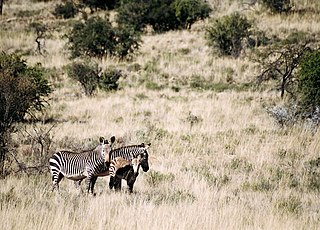
Mountain Zebra National Park is a national park in the Eastern Cape province of South Africa; proclaimed in July 1937 for the purpose of providing a nature reserve for the endangered Cape mountain zebra. It is surrounded by 896,146.57 hectares of the Mountain Zebra-Camdeboo Protected Environment.

<i>Aloidendron dichotomum</i> Species of tree

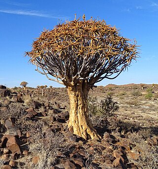
Aloidendron dichotomum, formerly Aloe dichotoma, the quiver tree or kokerboom, is a tall, branching species of succulent plant, indigenous to Southern Africa, specifically in the Northern Cape province of South Africa, and parts of Southern Namibia.

<span class="mw-page-title-main">Tankwa Karoo National Park</span> Conservation area west of Sutherland in the Western and Northern Cape

Tankwa Karoo National Park is a national park in South Africa. The park lies about 70 km due west of Sutherland near the border of the Northern Cape and Western Cape, in one of the most arid regions of South Africa, with areas receiving less than 100 mm of average annual precipitation, moisture-bearing clouds from the Atlantic Ocean being largely stopped by the Cederberg mountains. Other low areas receive little more, as the Roodewerf station with 180 mm of mean annual rainfall. In the hottest areas of the park, the mean maximum temperature in January is 38.9 °C, and in July the mean minimum temperature ranges from about 5 to 7 °C. Before this Park's proclamation, the only protected area of Succulent Karoo was the 2 square kilometre patch of the Gamkaberg Nature Reserve. Succulent Karoo has, together with the Cape Floral Kingdom, been declared a Biodiversity Hotspot by Conservation International.

<span class="mw-page-title-main">Table Mountain National Park</span> A nature conservation area on the Cape Peninsula in Cape Town, South Africa

Table Mountain National Park, previously known as the Cape Peninsula National Park, is a national park in Cape Town, South Africa, proclaimed on 29 May 1998, for the purpose of protecting the natural environment of the Table Mountain Chain, and in particular the rare fynbos vegetation. The park is managed by South African National Parks. The property is included as part of the UNESCO Cape Floral Region World Heritage Site.

<span class="mw-page-title-main">Boulders Beach</span> Beach in Cape Town, South Africa

Boulders Beach is a sheltered beach made up of inlets between granite boulders, from which the name originated. It is located on the Cape Peninsula, in Simon's Town in the Western Cape province of South Africa. It is also commonly known as Boulders Bay. It is a popular tourist spot because of a colony of African penguins which settled there in 1982. Boulders Beach forms part of the Table Mountain National Park.

<span class="mw-page-title-main">Augrabies Falls</span> Waterfall in Northern Cape, South Africa

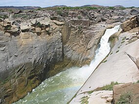
The Augrabies Falls is a waterfall on the Orange River, the largest river in South Africa. Since 1966 the waterfall, set in a desolate and rugged milieu, is enclosed by the Augrabies Falls National Park. The falls are around 183 feet (56 m) in height. Some sources cite an approximate height of 480 feet; this is actually the height from the base of the canyon to the top of the walls, not that of the falls themselves.

<span class="mw-page-title-main">Tsitsikamma National Park</span> Protected area on the Garden Route, Western Cape and Eastern Cape, South Africa

The Tsitsikamma National Park is a protected area on the Garden Route, Western Cape and Eastern Cape, South Africa. It is a coastal reserve well known for its indigenous forests, dramatic coastline, and the Otter Trail. On 6 March 2009 it was amalgamated with the Wilderness National Park and various other areas of land to form the Garden Route National Park.

<span class="mw-page-title-main">Springbok, South Africa</span> Place in Northern Cape, South Africa

Springbok is the largest town in the Namaqualand area in the Northern Cape province of South Africa. It was called Springbokfontein until 1911, when it was shortened to Springbok. Springbok is located on the N7 national route which connects the Cape with Namibia, and at the western end of the N14, which connects it with Upington and Pretoria. It is the main town of the Nama Khoi Local Municipality, which also includes a number of surrounding towns such as Okiep and Nababeep.

<span class="mw-page-title-main">Golden Gate Highlands National Park</span> National park in South Africa

Golden Gate Highlands National Park is located in Free State, South Africa, near the Lesotho border. It covers an area of 340 km2 (130 sq mi). The park's most notable features are its golden, ochre, and orange-hued, deeply eroded sandstone cliffs and outcrops, especially the Brandwag rock. Another feature of the area is the numerous caves and shelters displaying San rock paintings. Wildlife featured at the park includes mongooses, eland, zebras, and over 100 bird species. It is the Free State's only national park and is more famous for the beauty of its landscape than for its wildlife. Numerous palaeontology finds have been made in the park, including dinosaur eggs and skeletons.

Onseepkans is a small settlement on the banks of the Orange River in Northern Cape Province, South Africa. It is a border post with Namibia for traffic between Pofadder in South Africa and Keetmanshoop in Namibia. The name either originated from a combination of three Nama words: ‘tconsiep’, ‘nias’, and ‘tcaans’ (thorntrees), or a derivative of a nama word that means 'watering place for cattle'.

<span class="mw-page-title-main">Pofadder, South Africa</span> Place in Northern Cape, South Africa

Pofadder is a minuscule town in the Northern Cape province of South Africa. In spite of its small size, it is an important local centre in the region known in South Africa as Bushmanland. The surrounding districts are arid, sparsely populated, rugged and picturesque. There is little in the way of cropping and local farmers run sheep or goats for a living. As a tourist destination, it is not sufficiently spectacular to rival the spring flowers of the coastal regions of Namaqualand, but it has its attractions for biologists and conservationists and those with an interest in its remarkable diversity of often-tiny xerophytes and animal life. In recent years, the town economy has been booted by the construction and operation of solar power stations.

Cannon Rocks is a small seaside town on the Indian Ocean in the Eastern Cape Province, South Africa, between Boknes and the boundary of the Greater Addo Elephant Park. It is situated 135 km east of Port Elizabeth and 180 km west of East London approximately 15 minutes from the town of Kenton-on-Sea. Port Alfred is approximately 40 km to the East of Cannon Rocks via the R72 Road. Cannon Rocks is part of the Ndlambe Local Municipality in the Sarah Baartman District of the Eastern Cape.

<span class="mw-page-title-main">Royal Natal National Park</span>

Royal Natal National Park is a 80.94-square-kilometre (31.25 sq mi) park in KwaZulu-Natal province, South Africa and forms part of the uKhahlamba Drakensberg Park World Heritage Site. Notwithstanding the name, it is actually not a South African National Park managed by the SANParks, but rather a Provincial Park managed by Ezemvelo KZN Wildlife. This park is now included in the Maloti-Drakensberg Transfrontier Conservation Area Peace Park.

<span class="mw-page-title-main">Cecilia, Table Mountain</span> Section of the Table Mountain National Park

Cecilia is a section of the Table Mountain National Park on the lower eastern slopes of Table Mountain in Cape Town, located just to the south of Kirstenbosch National Botanical Garden. It was previously used for commercial logging and known as Cecilia Forest or Cecilia Plantation, but has now been given protected status and integrated into the National Park.

<span class="mw-page-title-main">Nieuwoudtville</span> Place in Northern Cape, South Africa

Nieuwoudtville is a town in Namakwa District Municipality in the Northern Cape province of South Africa. The town lies on the Bokkeveld Escarpment, and was established in 1897. The Nieuwoudtville Falls on the Doring River are located a few kilometres north of the town.

<span class="mw-page-title-main">Uisge Ban Falls Provincial Park</span> Provincial park in Nova Scotia, Canada

Uisge Ban Falls Provincial Park is a provincial park near New Glen, in the Canadian province of Nova Scotia on Cape Breton Island. Located on the North Branch Road 14.5 kilometres (9.0 mi) north of Baddeck, the civic address of the park entrance is 715 North Branch Road, Baddeck Forks, Nova Scotia, Canada B0E 1B0.

<span class="mw-page-title-main">Shingwedzi</span>

Shingwedzi is a rest camp and ranger's post situated in the northern section of the Kruger National Park. They are located on the southern bank of the Shingwedzi River, for which they were named, in Limpopo province, South Africa. The surrounding country formerly constituted the Singwitsi Reserve, proclaimed in 1903, which encompassed over 5,000 square kilometers. The region was over-hunted by the end of the 19th century, its big game depleted and its elephant population completely decimated. The name "Shingwedzi" is of Tsonga origin, and was perhaps derived from "Shing-xa-goli", perhaps a local chieftain, and "njwetse", the sound of iron rubbing against iron.

<span class="mw-page-title-main">Oorlogskloof Nature Reserve</span> Nature reserve in South Africa

The Oorlogskloof Nature Reserve, covers 4,776 hectares and is located 10 km south of Nieuwoudtville in the Northern Cape, South Africa.

References

  1. 1 2 Tony Pinchuck; Barbara McCrea; Donald Reid (2002). South Africa. Rough Guides. p. 323. ISBN   978-1-85828-853-6.
  2. "Augrabies Falls National Park (South African media online)". sanparks.africamediaonline.com/. Retrieved 30 July 2015.
  3. "Augrabies Falls National Park". SA Places. Retrieved 30 July 2015.
  4. Heather Du Plessis (1 January 2000). Tourism Destinations Southern Africa. Juta and Company Ltd. ISBN   978-0-7021-5272-6.
  5. "Augrabies Falls National Park" . Retrieved 30 July 2015.
  6. 1 2 3 Siyabona Africa."Augrabies Falls National Park, Northern Cape. South Africa". Siyabona Africa (Pty)Ltd - Private Tours and Safari. Accessed: 10 October 2018
  7. "Encounter South Africa: Augrabies Falls". Archived from the original on 26 January 2018. Retrieved 30 July 2015.
  8. "Augrabies Falls, Northern Cape" . Retrieved 30 July 2015.
  9. 1 2 3 4 Dassi Interpretive Trail."Augrabies Falls National Park, South Africa". SANPARKS. Accessed: 10 October 2018
  10. African Protected Area Conservation and Science (1997). "Popups on Moon Rock, Augrabies Falls National Park". Koedoe. 40 (2): 75–84. doi: 10.4102/koedoe.v40i2.274 . ISSN   0075-6458 . Retrieved 12 July 2010.
  11. 1 2 "AUGRABIES FALLS NATIONAL PARK - Dassie Interpretive Trail" (PDF).
  12. 1 2 "AUGRABIES FALLS NATIONAL PARK - Klipspringer Hiking Trail" (PDF).

Commons-logo.svg Media related to Augrabies Falls National Park at Wikimedia Commons