Namaqua National Park

Last updated

²

Namaqua National Park
Namaqua NP4.jpg
Spring flowers in the park
Namaqua National Park
Location of the park
Location Northern Cape, South Africa
Nearest city Kamieskroon
Coordinates 30°2′36″S17°35′10″E / 30.04333°S 17.58611°E / -30.04333; 17.58611
Area1,368.18 km2 (528.26 sq mi) [1]
Established2001 [1]
Governing body South African National Parks
sanparks.org/parks/namaqua
South Africa relief location map.svg
Red pog.svg
Namaqua National Park (South Africa)
South Africa Northern Cape relief location map.svg
Red pog.svg
Namaqua National Park (Northern Cape)

Namaqua National Park is a South African national park of 141,000 ha situated on the edge of the Atlantic coast of Namaqualand, an area covering 440,000 km2 located within the semi-desert Succulent Karoo biome. [2] [3] This biome is a biodiversity hotspot with the largest concentration of succulent plants in the world. [3] The park also has an arid environment with succulent plants. [4] The park was created to protect its flowers. [5] During the spring, wildflowers bloom there in a spectacular fashion. [3] The park's main tourist attraction is this abundant spring bloom of brightly coloured wildflowers. [4] [6]

Contents

It has an area of more than 1300 km2. It is approximately 495 km north of Cape Town and 22 km northwest of Kamieskroon. [2]

Geography and climate

Namaqua National Park is located in Northern Cape Province, near South Africa's border with Namibia. [3] The park is located approximately 495 km north of Cape Town and 22 km northwest of Kamieskroon. [2] It was officially gazetted in August 1999. [3] Skilpad Nature Reserve, formed in 1993 to protect Namaqualand's plant life, formed the nucleus of the new national park with the addition of 500 km2 of land to create the park. 270 km2 has since been added to the park, [7] and it now has an area of more than 700 km2. The park is semi-desert, with hot and dry summers and cold winters with variable, generally sparse rainfall. Most precipitation occurs between May and August. The eastern part of the park receives more rainfall than the west. [2]

Biodiversity

The park is located in Namaqualand, which lies within the Succulent Karoo. Namaqualand has an area covering 440,000 km2, located in the northwest corner of Northern Cape Province. [2] [3]

Biome

The park is part of the semi-desert Succulent Karoo biome, [2] [3] one of the most unusual biomes in the world. This biome is a biodiversity hotspot with the greatest biodiversity and the highest concentration of succulent plants of any of the world's arid regions. [6] The biome has an area of about 107,200 km2, stretching along South Africa's and southern Namibia's western coasts, and includes most of the Richtersveld. There are more than 5,000 plant species in this biome, including more than a third of all the succulent species in the world. Approximately 40% of the biome's plant species are endemic and 18% are threatened. The biome also has diverse invertebrate and reptile species, some of which are endemic. Illegal plant harvesting, overgrazing, and mining threaten endemic species. Only a very small percentage of the Succulent Karoo's area is formally protected, including the Knersvlakte Nature Reserve, the Richtersveld Community Conservancy, and Namaqua National Park. [6]

Flora

During most of the year, very little flora except hardy shrubs can be seen in Namaqualand's arid landscape. [8] However, in August and September, after the winter's rains, wildflowers bloom in a spectacular fashion [8] over hundreds of square kilometres. [5] These many-coloured flowers include daisies, lilies, aloes, and perennial herbs. [8] Namaqualand is famous throughout the world for the spectacular sight of its many coloured wildflowers during the spring. [3] [5] About 4,000 plant species grow in this area, [8] and Namaqualand has more than 1,000 types of flowers that do not grow anywhere else in the world. It has many species of succulent plants, for example vygies which have attractive blooms. The plump leaves of many types of succulents retain moisture, and many of them grow low to the ground and have a stone-like appearance. [5] Some species of trees here can store water in the dry environment, such as the quiver tree's fat trunk. [5] The flowers' blooms are dependent on the amount of rainfall that the area receives. The flowers are sensitive to sunlight and many will only open when there is bright sunshine. The flowers face the sun, and they generally open completely from about 10 am to 4 pm. Hot winds can cause the blooms to quickly shrivel. [8]

Steenbok amongst the fynbos vegetation Namaqua National Park, Northern Cape, South Africa (10993951046).jpg
Steenbok amongst the fynbos vegetation

Fauna

The speckled padloper, the smallest tortoise in the world, can be found in the park. [4]

Many insect species are attracted to the flowers. [6]

By 2017, arachnids from 21 families have been sampled in the park, which included 60 species of spiders. Hottentotta arenaceus , is a pale orange-yellow scorpion which occurs in the park's coastal section. Diaphorocellus biplagiatus and Asemesthes affinis occur, the latter species only found again in Angola. Xysticus cribratus has been recorded, though it has an extensive global range. [9]

Tourism

An estimated 100,000 tourists visit Namaqualand every year. 65% of these visitors are South African and 35% are from other countries. The government has identified tourism as a means to improve the region's economy, and tourism in this area has been promoted through marketing. However, the region's residents continue to have very low incomes and there is a high unemployment rate. [3]

Namaqua National Park has the ecological tourist attractions of the wider Namaqualand region. [3] The bloom of spring flowers in disused wheat fields is the park's main tourist attraction. Tourist facilities include a 5 km long scenic route, two nature walks, places to picnic, and an information centre for visitors. The park has not yet been fully developed and the Skilpad area of the park can only be visited by tourists during the flower season in the spring. [7] Most of the wildflower species are protected under law, with the possibility of fines for those who pick them. [8]

There are now 4 chalets available for overnight accommodation, 1 of which is accessible to disabled persons. Accommodation is for 2 adults with provision for 1 adult or 2 children on a sleep couch. There is 220 V electricity, but guests are required to bring all their own provisions, as the nearest basic shop is 22 km distant. [4]

Related Research Articles

<span class="mw-page-title-main">Geography of South Africa</span>

South Africa occupies the southern tip of Africa, its coastline stretching more than 2,850 kilometres from the desert border with Namibia on the Atlantic (western) coast southwards around the tip of Africa and then northeast to the border with Mozambique on the Indian (eastern) coast. The low-lying coastal zone is narrow for much of that distance, soon giving way to a mountainous escarpment that separates the coast from the high inland plateau. In some places, notably the province of KwaZulu-Natal in the east, a greater distance separates the coast from the escarpment. Although much of the country is classified as semi-arid, it has considerable variation in climate as well as topography. The total land area is 1,220,813 km2 (471,359 sq mi). It has the 23rd largest Exclusive Economic Zone of 1,535,538 km2 (592,875 sq mi).

<span class="mw-page-title-main">Namaqualand</span> Arid region of Namibia and South Africa

Namaqualand is an arid region of Namibia and South Africa, extending along the west coast over 1,000 km (600 mi) and covering a total area of 440,000 km2 (170,000 sq mi). It is divided by the lower course of the Orange River into two portions – Little Namaqualand to the south and Great Namaqualand to the north.

<span class="mw-page-title-main">Karoo</span> Semi-desert region in South Africa

The Karoo is a semi-desert natural region of South Africa. No exact definition of what constitutes the Karoo is available, so its extent is also not precisely defined. The Karoo is partly defined by its topography, geology and climate, and above all, its low rainfall, arid air, cloudless skies, and extremes of heat and cold. The Karoo also hosted a well-preserved ecosystem hundreds of million years ago which is now represented by many fossils.

<i>Aloidendron dichotomum</i> Species of tree

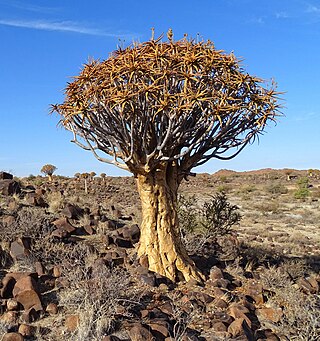
Aloidendron dichotomum, formerly Aloe dichotoma, the quiver tree or kokerboom, is a tall, branching species of succulent plant, indigenous to Southern Africa, specifically in the Northern Cape province of South Africa, and parts of Southern Namibia.

<span class="mw-page-title-main">Tankwa Karoo National Park</span> Conservation area west of Sutherland in the Western and Northern Cape

Tankwa Karoo National Park is a national park in South Africa. The park lies about 70 km west of Sutherland and along the border of the Northern Cape and Western Cape in Succulent Karoo habitat; a biodiversity hotspot and one of the most arid regions of South Africa.

<span class="mw-page-title-main">Springbok, South Africa</span> Town in Northern Cape, South Africa

Springbok is the largest town in the Namaqualand area in the Northern Cape province of South Africa. It was called Springbokfontein until 1911, when it was shortened to Springbok. Springbok is located on the N7 national route which connects the Cape with Namibia, and at the western end of the N14, which connects it with Upington and Pretoria. It is the main town of the Nama Khoi Local Municipality, which also includes a number of surrounding towns such as Okiep and Nababeep.

<span class="mw-page-title-main">Kamieskroon</span> Place in Northern Cape, South Africa

Kamieskroon is a small town in the Kamiesberg Local Municipality, lying in the foothills of the Kamiesberge at an elevation of approximately 800 m. The town is more or less in the centre of Namaqualand, about 70 km (43 mi) to the south of Springbok, Northern Cape, South Africa. It is known mainly for its abundance of wild flowers during spring.

<span class="mw-page-title-main">Richtersveld</span> Desert in South Africa

The Richtersveld is a desert landscape characterised by rugged kloofs and high mountains, situated in the north-western corner of South Africa’s Northern Cape province. It is full of changing scenery from flat, sandy, coastal plains, to craggy sharp mountains of volcanic rock and the lushness of the Orange River, which forms the border with neighboring Namibia. The area ranges in altitude from sea level, to 1,377 m (4,518 ft) at Cornellberg. Located in the north-western side of the Northern Cape province in South Africa, the Richtersveld is regarded as the only arid biodiversity hotspot on earth and the majority of the area is inscribed on UNESCO's World Heritage List due to its cultural values.

<i>Pachypodium namaquanum</i> Species of tree

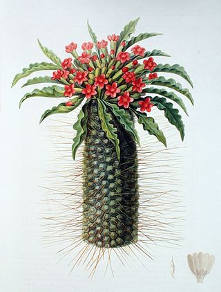
Pachypodium namaquanum, also known as halfmens or elephants trunk, is a succulent plant of Southern Africa. The genus name Pachypodium is from the Greek for 'thick foot', an allusion to its swollen base, while the species name namaquanum is a reference to Namaqualand.

<span class="mw-page-title-main">Wildlife of South Africa</span>

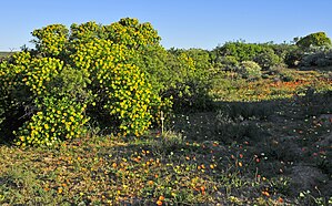
The wildlife of South Africa consists of the flora and fauna of this country in Southern Africa. The country has a range of different habitat types and an ecologically rich and diverse wildlife, vascular plants being particularly abundant, many of them endemic to the country. There are few forested areas, much savanna grassland, semi-arid Karoo vegetation and the fynbos of the Cape Floristic Region. Famed for its national parks and big game, 297 species of mammal have been recorded in South Africa, as well as 849 species of bird and over 20,000 species of vascular plants.

<span class="mw-page-title-main">Namaqua rain frog</span> Species of amphibian

The Namaqua rain frog or Namaqua short-headed frog is a species of frogs in the family Brevicipitidae. It is found in Namaqualand in western South Africa and extreme southern Namibia.

<span class="mw-page-title-main">Kamiesberge</span>

The Kamiesberg or Kamiesberge, is a mountain range of jumbled granite inselbergs or bornhardts dotted over sandy plains and centered on Kamieskroon in Namaqualand in South Africa. This range is very like the Matopos of Zimbabwe in appearance. It stretches for about 140 km (60 mi) from Garies in the south to Springbok in the north and forms a plateau between the Sandveld of the Cape West Coast and Bushmanland in the east, with the Hardveld of the mountainous central Kamiesberg escarpment in the midst.

<span class="mw-page-title-main">Nieuwoudtville</span> Place in Northern Cape, South Africa

Nieuwoudtville is a town in Namakwa District Municipality in the Northern Cape province of South Africa. The town lies on the Bokkeveld Escarpment, and was established in 1897. The Nieuwoudtville Falls on the Doring River are located a few kilometres north of the town.

<i>Larryleachia cactiformis</i> Species of flowering plant

Larryleachia cactiformis is a stapeliad succulent, native to the Richtersveld and Namaqualand in South Africa, where it grows in rocky areas. Larryleachia cactiformis proves as difficult a member of the family Apocynaceae in cultivation as others in its genus.

<i>Crassula nudicaulis</i> Species of succulent

Crassula nudicaulis is a succulent plant native to South Africa, and Lesotho.

The following index is provided as an overview of and topical guide to the protected areas of South Africa:

<span class="mw-page-title-main">Goegap Nature Reserve</span> Nature reserve in South Africa

The Goegap Nature Reserve is a semi-desert nature reserve in Northern Cape, South Africa and lies around 8 km (5.0 mi) east of Springbok. The area was once used to graze livestock and was proclaimed in 1966 as a reserve then fenced in 1969 and wildlife introduced shortly afterward. It was originally known as the Hester Malan Nature Reserve.

<i>Tylecodon paniculatus</i> Species of succulent

Tylecodon paniculatus, also known as butter bush, butter tree, butterboom or rooisuikerblom (Afrikaans), is a species of succulent plant in the genus Tylecodon belonging to the family Crassulaceae.

<i>Adromischus alstonii</i> Species of plant

Adromischus alstonii is a species of succulent plant from the family Crassulaceae. The species name is the namesake of Edward Garwood Alston, who was a plant enthusiast from Cape Province, South Africa. A. alstonii is endemic to the Succulent Karoo in the Northern Cape, South Africa.

References

  1. 1 2 "Namaqua National Park". World Database on Protected Areas.
  2. 1 2 3 4 5 6 Van Deventer, M. and J.A.J. Nel. 2006. Habitat, food, and small mammal community structure in Namaqualand. Koedoe 49(1): 99–109. Pretoria. ISSN 0075-6458
  3. 1 2 3 4 5 6 7 8 9 10 Martin, Vance; Muir, Andrew (2004). Wilderness And Human Communities: The Spirit Of The 21st Century: Proceedings From The 7th World Wilderness Congress. Fulcrum Publishing. p. 193. ISBN   1-55591-866-2 via Google Books.
  4. 1 2 3 4 "Namaqua National Park". South African National Parks. Retrieved 2008-09-18.
  5. 1 2 3 4 5 Exploring our Provinces: Northern Cape. Jacana Media. 2007. p. 11. ISBN   978-1-77009-267-9.
  6. 1 2 3 4 Odendaal, Francois; Suich, Helen; Velásquez Rojas, Claudio (2007). Richtersveld: The Land and Its People. Struik. p. 169. ISBN   978-1-77007-341-8. Archived from the original on 2018-09-25. Retrieved 2016-10-19.
  7. 1 2 Olivier, Willie; Olivier, Sandra (2005). Touring in South Africa: The Great SA Road Trip Guide. Struik. p. 169. ISBN   1-77007-142-3. Archived from the original on 2018-09-25. Retrieved 2016-10-19.
  8. 1 2 3 4 5 6 Blond, Becca; Fitzpatrick, Mary; Pitcher, Gemma; Richmond, Simon; Warren, Matt (2004). South Africa, Lesotho & Swaziland. Lonely Planet. p. 509. ISBN   1-74104-162-7.
  9. van Jaarsveld, Taryn Arnott (2017-09-13). "Finding out more about Namaqua National Park's arachnids". Die Laevelder. Archived from the original on 2017-09-13. Retrieved 14 September 2017.