Waterberg Biosphere

Last updated

Waterberg
(Thaba Meetse)
Lapalalariverdown.jpg
River gorge in the Lapalala Wilderness of the Waterberg showing horizontal sandstone layering
Highest point
Peak Geelhoutkop [1]
Elevation 1,830 m (6,000 ft)
Listing List of mountain ranges of South Africa
Coordinates 24°4′30″S28°8′30″E / 24.07500°S 28.14167°E / -24.07500; 28.14167
Dimensions
Length170 km (110 mi)NE/SW
Width80 km (50 mi)NW/SE
Geography
South Africa relief location map.svg
Red triangle with thick white border.svg
Waterberg
(Thaba Meetse)
near Vaalwater
Country South Africa
Province Limpopo
Geology
Orogeny Kaapvaal Craton
Age of rock Neoarchean to early Paleoproterozoic
Type of rock Bushveld Igneous Complex, sandstone
Climbing
Easiest route From the towns of Vaalwater or Bela-Bela

The Waterberg (Northern Sotho : Thaba Meetse) is a mountainous massif of approximately 654,033 hectare in north Limpopo Province, South Africa. The average height of the mountain range is 600 m with a few peaks rising up to 2000 m above sea level. Vaalwater town is located just north of the mountain range. The extensive rock formation was shaped by hundreds of millions of years of riverine erosion to yield diverse bluff and butte landform. [2] The ecosystem can be characterised as a dry deciduous forest or Bushveld. Within the Waterberg there are archaeological finds dating to the Stone Age, and nearby are early evolutionary finds related to the origin of humans.

Contents

Waterberg (Thaba Meetse) is the first region in the northern part of South Africa to be named as a Biosphere Reserve by UNESCO.

Geology

The underlying rock formation derives from the Kaapvaal Craton, formed as a precursor island roughly 2.7 billion years ago. This crustal formation became the base of the Waterberg, which was further transformed by upward extrusion of igneous rocks. [3] These extruded rocks, containing minerals such as vanadium and platinum, are called the Bushveld Igneous Complex. The original extent of this rock upthrust involved about 250,000 square kilometres, and is sometimes called the Waterberg Supergroup.

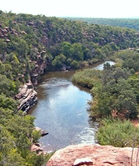
Sedimentary deposition from rivers cutting through Waterberg endured until roughly 1.5 billion years ago. In more recent time (around 250 million years ago) the Kaapvaal craton collided with the supercontinent Gondwana, and split Gondwana into its modern-day continents.[ citation needed ] Waterberg today contains mesas, buttes and some kopje outcrops. Some of cliffs stand up to 550 meters above the plains, with exposed multi-coloured sandstone.

History

Bushman Stone Age rock painting, Lapalala Wilderness, Waterberg, South Africa. Lapalaladeeronrockdown.jpg
Bushman Stone Age rock painting, Lapalala Wilderness, Waterberg, South Africa.

The sandstone formations could retain groundwater sufficient to make a suitable environment for primitive man. The cliff overhangs offered natural shelters for these early humans. The first human ancestors may have been at Waterberg as early as three million years ago, since Makapansgat, 40 kilometres distant, has yielded skeletons of Australopithecus africanus . [2] Hogan suggests that Homo erectus, whose evidence remains were also discovered in Makapansgat, "may have purposefully moved into the higher areas of the Waterberg for summer (December to March) game".

Bushmen entered Waterberg around two thousand years ago. They produced rock paintings at Lapalala within the Waterberg, including depictions of rhinoceros and antelope. Early Iron Age settlers in Waterberg were Bantu, who had brought cattle to the region. The Bantu created a problem in Waterberg, since cattle reduced grassland caused invasion of brush species leading to an outbreak of the tsetse fly. The ensuing epidemic of sleeping sickness depopulated the plains, but at higher elevations man survived, because the fly cannot survive above 600 meters.

Later people left the first Stone Age artefacts recovered in northern South Africa. Starting about the year 1300 AD, Nguni settlers arrived with new technologies, including the ability to build dry-stone walls, which techniques were then used to add defensive works to their Iron Age forts, some of which walls survive to today. Archaeologists continue to excavate Waterberg to shed light on the Nguni culture and the associated dry-stone architecture.

The first white settlers arrived in Waterberg in 1808 and the first naturalist a Swede appeared just before mid 19th century. Around the mid 19th century, a group of Afrikaner travellers set out from Cape Town in search of Jerusalem. Arriving in Waterberg, they mis-estimated their distance and thought they had reached Egypt.

After battles between Boer settlers and tribesmen, the races co-existed until around 1900. The Boers brought further cattle grazing, multiplying the impacts of indigenous tribes. By the beginning of the 20th century there were an estimated 200 western inhabitants of the Waterberg, [4] and grassland loss began to have a severe impact upon native wildlife populations.

Ecology

Male and female Black-headed orioles in courtship ritual, riparian zone of central Waterberg, South Africa Waterbergoriolesdownsized.jpg
Male and female Black-headed orioles in courtship ritual, riparian zone of central Waterberg, South Africa
The Sandrivier range near Vaalwater constitutes one section of the Waterberg escarpment. It consists of coarse grained, yellow, cross-bedded sandstone. Sandrivierberge in Waterberg, Vaalwater, a.jpg
The Sandrivier range near Vaalwater constitutes one section of the Waterberg escarpment. It consists of coarse grained, yellow, cross-bedded sandstone.

There are several sub-habitats within the Waterberg Biosphere, which is fundamentally a dry deciduous forest; according to Hogan: "These sub-habitats include high plateau savanna , specialized shaded cliff vegetation system and riparian zone habitat with associated marshes". [2]

Flora and fauna

The savanna consists of rolling grasslands and a semi-deciduous forest, with trees such as mountain syringa, silver cluster-leaf and lavender tree. The canopy is mostly leafless during the dry winter. Native grasses include signal grass, goose grass and heather-topped grass. Indigenous grasses provide graze to support native species including impala, kudu, klipspringer and blue wildebeest. Some Pachypodium habitats are found especially in isolated kopje formations.

Other indigenous mammals include giraffe, white rhinoceros and warthog. Snakes include the black mamba and spitting cobra. In 1905 Eugene Marais studied these snakes of the Waterberg. [5] Some birds seen are the black-headed oriole and the white-backed vulture. [6] Predators include the leopard, hyena and lion.

Vegetative cliff habitats are abundant in the Waterberg due to the extensive historic riverine erosion. The African porcupine uses the protection of these cliffside caves. Some trees cling to the cliff areas, including the paperbark false-thorn, that have flaking bark hanging from their thick trunks. Another tree in this habitat is the fever tree, thought by Bushmen to have special power to allow communication with the dead. It is found on cliffs above the Palala River including one site used for prehistoric ceremonies, which is also a location of some intact rock paintings.

Riparian zones are associated with various rivers that cut through Waterberg. These surface waters all drain to the Limpopo River which flows easterly to discharge into the Indian Ocean. The river bushwillow is a riparian tree in this habitat. These riparian zones offer habitat for birds, reptiles and mammals that require more water than plateau species. The riverine areas are inhabited by the apex predator Nile crocodile and the hippopotamus. These wet habitats have reduced numbers of water-living insects, and the Waterberg is thus considered an almost malaria-free region.

Land management

As of 2006 about 80,000 people lived on the Waterberg plateau, which is part of the Bushveld district of Limpopo Province of South Africa. After cattle grazing wrought ecological havoc in the mid 1900s, the land owners of the region became aware of the benefits of restoring habitat to attract and protect the original species of antelope, white rhino, giraffe, hippopotami, and other species whose numbers dropped in the era of intense cattle grazing.

The rise in eco-tourism has stimulated interest in soil conservation practices to restore original grass species to the Waterberg. The land management practises required are expensive, but repay the landowner with added value in wildlife habitat. There is also a trend for larger farms and open space areas with the resultant advantage of fence removal. This outcome not only benefits large mammal migration, but yields an improved gene pool.

Protected areas

Waterberg Biosphere Reserve
Waterberg Biosphere
Waterberg Biosphere Reserve
Location Limpopo, South Africa
Nearest city Lephalale
Coordinates 23°55′S28°05′E / 23.917°S 28.083°E / -23.917; 28.083
Area654,033 ha (1,616,150 acres)
Established2001;22 years ago (2001)
Governing bodyWaterberg Biosphere Reserve
waterbergbiosphere.com
South Africa Limpopo relief location map.svg
Red pog.svg
Waterberg Biosphere (Limpopo)
South Africa relief location map.svg
Red pog.svg
Waterberg Biosphere (South Africa)

UNESCO Waterberg Biosphere Reserve

The Waterberg Biosphere Reserve was designated in 2001. It has a total area of 654 033 hectares. [7]

The Welgevonden Game Reserve covers 37,500 hectares of the plateau. [8] The Kololo Game Reserve covers 3000 hectares, part of which is in the Welgevonden Private Game Reserve, and part of which is completely protected. [9]

The Lapalala Wilderness Nature Reserve, just north of Melkrivier covers approximately 48’000 hectares and is the largest private game reserve in the Waterberg and the Limpopo province.

See also

Related Research Articles

<span class="mw-page-title-main">Limpopo</span> Northernmost province of South Africa

Limpopo is the northernmost province of South Africa. It is named after the Limpopo River, which forms the province's western and northern borders. The capital and largest city in the province is Polokwane, while the provincial legislature is situated in Lebowakgomo.

Modimolle, also known as Nylstroom, is a town located near the southern edge of the Waterberg Massif in Limpopo province, South Africa. It is a medium-sized town that focuses primarily on agriculture and farming as well as wildlife and tourism. Nylstroom is also located approximately 135 kilometres north of Pretoria, South Africa's capital city.

Lephalale, also known as Ellisras, is a coal mining town in the Limpopo province of South Africa immediately east of the Waterberg Coalfield. The town was established as Ellisras in 1960 and named after Patrick Ellis and Piet Erasmus who settled on a farm there in the 1930s. In 2002, Ellisras was renamed Lephalale by the provincial government of Limpopo, after the main river that crosses the municipality. Lephalale is divided into three main subsections, Ellisras, Onverwacht and Marapong. Lephalale is derived from the setswana language meaning "to flow".

<span class="mw-page-title-main">Vaalwater</span> Place in Limpopo, South Africa

Vaalwater is a small town situated on the Mokolo River in the Limpopo province of South Africa.

<span class="mw-page-title-main">Mokopane</span> Place in Limpopo, South Africa

Mokopane, also known as Potgietersrus, is a town in the Limpopo province of South Africa.

<span class="mw-page-title-main">Highveld</span> Geographic region of the South African inland plateau

The Highveld is the portion of the South African inland plateau which has an altitude above roughly 1500 m, but below 2100 m, thus excluding the Lesotho mountain regions to the south-east of the Highveld. It is home to some of the country's most important commercial farming areas, as well as its largest concentration of metropolitan centres, especially the Gauteng conurbation, which accommodates one-third of South Africa's population.

<span class="mw-page-title-main">Bushveld</span> Sub-tropical woodland ecoregion of Southern Africa

The Bushveld is a sub-tropical woodland ecoregion of Southern Africa. The ecoregion straddles the Tropic of Capricorn and constitutes the southern part of the Zambezian region. It encompasses most of Limpopo and a small part of North West in South Africa, the Central and North-East Districts of Botswana and the Matabeleland South and part of Matabeleland North provinces of Zimbabwe. The Kruger National Park has a number of 'Bushveld' camps, but these are strictly speaking in the lowveld, as these terms are sometimes used interchangeably. Although their limits are somewhat blurred, lowveld is generally restricted to the more easterly parts of South Africa and Zimbabwe.

<span class="mw-page-title-main">Waterberg District Municipality</span> District Municipality in Limpopo, South Africa

The Waterberg District Municipality is one of the 5 districts of the Limpopo province of South Africa. The seat is Modimolle. As of 2016, the majority of its 745,758 residents spoke Sepedi, also known as Northern Sotho. The district code is DC36.

<span class="mw-page-title-main">Kaapvaal Craton</span> Archaean craton, possibly part of the Vaalbara supercontinent

The Kaapvaal Craton, along with the Pilbara Craton of Western Australia, are the only remaining areas of pristine 3.6–2.5 Ga crust on Earth. Similarities of rock records from both these cratons, especially of the overlying late Archean sequences, suggest that they were once part of the Vaalbara supercontinent.

<span class="mw-page-title-main">Mokolo River</span> River in Limpopo Province, South Africa

The Mokolo River is a major watercourse in Limpopo Province of South Africa. This river collects much of the drainage of the Waterberg Massif and discharges it to the Limpopo River. The river's catchment area comprises 8,387 square kilometres (3,238 sq mi).

<span class="mw-page-title-main">Palala River</span> River in Limpopo Province, South Africa

The Palala or Lephalala River, also called the Rhooebok-river by Thomas Baines, is a river in South Africa. This river's catchment basin is a sub-watershed of the Limpopo River.

<span class="mw-page-title-main">Lapalala Wilderness</span> Conservation area in South Africa

Lapalala Wilderness is a 48,000 hectare Big 5 conservation area situated within the UNESCO declared Waterberg Biosphere and protected under the National Environmental Management Protected Areas Act of 57 of 2003.

<span class="mw-page-title-main">Komati Gorge</span>

Komati Gorge is a river valley in the Mpumalanga Province in central South Africa, which features vertical sandstone cliffs that provide habitat for a wide diversity of wildlife. Komati Gorge is located near the communities of Carolina and Machadodorp. The Komati River flows through the gorge and provides riparian cover for many species of flora and fauna, including several endemic endangered species and big game animals. The geology of the vertical cliffs of the gorge offer a diverse set of colourful mineralized exposures.

<span class="mw-page-title-main">Wildlife of Benin</span> Natural flora and fauna of Benin

Benin has varied resources of wildlife comprising flora and fauna, which are primarily protected in its two contiguous protected areas of the Pendjari National Park and W National Park. The former is known for many species of avifauna and the latter park is rich in mammals and predators. In addition, many other forest reserves are noted in the country but are not easily accessible, well protected or adequately surveyed for its wildlife resources. The protected area of Benin which is defined as a National Protected Area System is in northern Benin, mostly with a woody savanna ecosystem. It covers 10.3 percent of the nation and is part of the three-nation W-Arly-Pendjari Complex (WAP).

<span class="mw-page-title-main">Mapungubwe National Park</span> National park in Limpopo, South Africa

Mapungubwe National Park is a national park in the Limpopo Province, South Africa. The park protects the historical site of Mapungubwe Hill, which was the capital of the Kingdom of Mapungubwe, as well as the wildlife and riverine forests along the Limpopo River. The Mapungubwe Hill was the site of a community dating back to the Iron Age. Evidence has shown that it was a prosperous community. Archaeologists also uncovered the famous Golden Rhinoceros of Mapungubwe figurine from the site.

Blyde River Canyon Nature Reserve is situated in the Drakensberg escarpment region of eastern Mpumalanga, South Africa. The reserve protects the Blyde River Canyon, including sections of the Ohrigstad and Blyde Rivers and the geological formations around Bourke's Luck Potholes, where the Treur River tumbles into the Blyde below. Southwards of the canyon, the reserve follows the escarpment, to include the Devil's and God's Window, the latter a popular viewpoint to the lowveld at the reserve's southern extremity.

The Mokolo Dam Nature Reserve or Mokolo Dam Provincial Park is a protected area of bushveld in the Limpopo province, South Africa. It almost surrounds the Mokolo Dam on the Mokolo River. It is located 32 km south of Lephalale, just northeast of the Marakele National Park and not far from the Lapalala Game Reserve.

Welgevonden Game Reserve,, is in the Waterberg District, of the Limpopo, province of South Africa. Welgevonden Game Reserve,, is a 38,200ha game reserve in the Waterberg District, of the Limpopo Province of South Africa.

<span class="mw-page-title-main">Magaliesberg Biosphere Reserve</span> UNESCO Biosphere Reserve in the North West and Gauteng provinces, South Africa

The Magaliesberg Biosphere Reserve is located in South Africa between the cities of Pretoria and Johannesburg to the east and Rustenburg to the west. The reserve lies at the interface of two great African biomes — the Central Grassland Plateaux and the sub-Saharan savannah — and the remnants of a third biome, the Afro‐montane forest. The rich biodiversity includes floral species such as Aloe peglerae and Frithia pulchra, and faunal species such as the forest shrew, sable antelope and 443 bird species representing 46.6% of total bird species in the southern African sub-region.

References

  1. Geelhoutkop - Waterberg Biosphere Reserve
  2. 1 2 3 C. Michael Hogan, Mark L. Cooke and Helen Murray, The Waterberg Biosphere, Lumina Technologies, 22 May 2006. "Lumaw". Archived from the original on 1 March 2012. Retrieved 10 June 2010.
  3. William Taylor, Gerald Hinde and David Holt-Biddle, The Waterberg, Struik Publishers, Cape Town, South Africa (2003) ISBN   1-86872-822-6
  4. The Encyclopedic History of the Transvaal, Praagh and Lloyd, Johannesburg (1906)
  5. Eugene Marais, Soul of the Ape, Human and Rousseau (1937)
  6. Tracey Hawthorne, Common Birds of South Africa, Struik Publishing, South Africa (1998) ISBN   1-86872-120-5
  7. "Waterberg Biosphere Reserve, South Africa". UNESCO. 6 March 2019. Retrieved 25 October 2023.
  8. "Welgevonden Game Reserve". Archived from the original on 4 September 2013.
  9. "Kololo Game Reserve". Archived from the original on 26 August 2012.