This is a list of mountain ranges of South Africa.
This is a list of mountain ranges of South Africa.
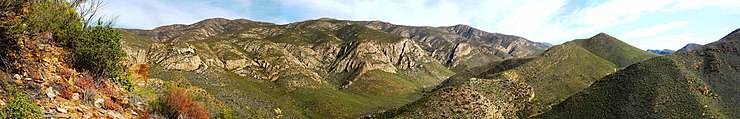
The list includes chains of mountains bordered by highlands or separated from other mountains by passes or valleys. Some ranges in South Africa are relatively isolated, while others are physiographically part of larger geographical ranges such as the Drakensberg.
Individual mountains within the same mountain range do not necessarily have the same geology; for example, in the [ dubious ] Witwatersrand there is Pilanesberg, a mountain having a different orogeny from the main range and its subranges. [1]
Geologically, many ranges are part of the Cape Fold Belt system, a wide geological system that also includes the Drakensberg.[ citation needed ]
| Name of Range | English translation | Location | Length (km) | Highest elevation (m) | Remarks |
|---|---|---|---|---|---|
| Amatola Mountains (also known as Knysna-Amatola) | Calves (in Xhosa) | Eastern Cape, Western Cape| | |||
| Asbestos Mountains | named for minerals mined | Northern Cape | |||
| Balelesberge | Balele Mountains | KwaZulu-Natal | |||
| Bamboesberg | named for Thamnocalamus tessellatus | Eastern Cape | An outlier of the Drakensberg Mountains | ||
| Bankberg | Bank Mountains | Eastern Cape | |||
| Baviaanskloof berge | Baboon's Gorge Mountains | Eastern Cape | |||
| Blouberg | Blue Mountains | Limpopo | |||
| Bronberge | Source/Well Mountains | Gauteng | |||
| Cederberg | Ceder Mountains | Western Cape | |||
| Drakensberg called Maloti Mountains in Lesotho | Dragons Mountains | Eastern Cape, Free State, KwaZulu-Natal | This range is made up of the "High Berg" basalt range, and the "Small Berg" sandstone range. | ||
| Drakenstein | Dragons stone Mountains | Western Cape | 1,590 m (5,220 ft) | Part of the Cape Fold Belt system | |
| Du Toitskloof | Du Toit's Canyon | Western Cape | 1,995 m (6,545 ft) | Part of the Cape Fold Belt system | |
| Gatsrand | Hole Ridge | Gauteng | |||
| Groot Swartberge | Great Black Mountains | Western Cape | |||
| Groot Winterhoekberge | Great Winter Corner Mountains | Western Cape | |||
| Hawekwa Berge | Hawequa Mountains - Khoi word meaning "the man in the mountain" | Western Cape | North of the Du Toitskloof Range. Part of the Cape Fold Belt System | ||
| Hex River Mountains | Witch River Mountains | Western Cape | Part of the Cape Fold Belt system | ||
| Hottentots-Holland | (Hottentot: old name for Khoi aboriginal inhabitants) | Western Cape | 1,590 m (5,220 ft) | Part of the Cape Fold Belt system | |
| Kammanassieberge | Kammanassie Mountains | Western Cape | 1,995 m (6,545 ft) | ||
| Kamiesberge | Jumbled Mountains | Northern Cape | 1,706 m (5,597 ft) | ||
| Kareeberge | Karoo Mountains | Western Cape | |||
| Kleinrivier Mountains | Small River Mountains | Western Cape | Part of the Cape Fold Belt system | ||
| Kogelberg | Bullet, or cone-shaped Mountains | Western Cape | Part of the Cape Fold Belt system | ||
| Komsberg | Rough mountain (in Khoekhoen) [2] | Eastern Cape | Part of the Drakensberg system | ||
| Koranna Mountains | named after a tribe | Northwest | |||
| Kouebokkeveld Mountains | Cold Bucks Field Mountains | Western Cape | |||
| Kouga Mountains | named after the Kouga River (‘hippos’) | Eastern Cape | Part of the Cape Fold Belt system | ||
| Langeberg | Long Mountains | Western Cape | 2,075 m (6,808 ft) | Part of the Cape Fold Belt system | |
| Langkloof Mountains | Long Valley/Gap Mountains | Western Cape | Part of the Cape Fold Belt system | ||
| Lebombo Mountains | Big nose (in Zulu) | from KwaZulu-Natal to Limpopo | |||
| Magaliesberg | Mogale's Mountain | North West | |||
| Murchison Range | named after a prospector | Limpopo | |||
| Nuweveldberge | New Field Mountains | Western Cape | Part of the Drakensberg system | ||
| Olifants River Mountains | Elephant's River Mountains | Western Cape | Part of the Cape Fold Belt system | ||
| Onverwacht series | Unexpected Mountains | Limpopo | |||
| Outeniqua | They who bear honey, Mountains | Western Cape | Part of the Cape Fold Belt system | ||
| Piketberg | Picket Mountains | Western Cape | Part of the Cape Fold Belt system | ||
| Rietfonteinrand | Reed Fountain Ridge | Gauteng | |||
| Riviersonderend Mountains | River without end Mountains | Western Cape | Part of the Cape Fold Belt system | ||
| Roggeveld Mountains | Rye Field Mountains | Northern Cape | |||
| Rooiberg | Red Mountains | Rooiberg | |||
| Simonsberg | Simon's Mountains | Western Cape | Part of the Cape Fold Belt system | ||
| Skurweberge | Rough or scaly Mountains | Western Cape | Part of the Cape Fold Belt system | ||
| Sneeuberge | Snow Mountains | Eastern Cape | |||
| Soutpansberg | Saltpan Mountain | Limpopo | |||
| Steenkampsberg | Steenkamp's Mountain | Mpumalanga | |||
| Stettynsberge | Stettyn's Mountains | Western Cape | Part of the Cape Fold Belt system | ||
| Stormberg Mountains | Storm Mountains | Eastern Cape | Part of the Drakensberg system | ||
| Strydpoort Mountains | Battle Gate Mountains | Limpopo | |||
| Suikerbosrand | Sugar Bush Ridge | Gauteng | |||
| Suurberg | Sour Mountains | Eastern Cape | Part of the Drakensberg system | ||
| Swartberg | Black Mountains | Western Cape | Part of the Cape Fold Belt system | ||
| Table Mountain Group | a mesa (tableland) | Western Cape | |||
| Tsitsikamma Mountains | Place of Much Water Mountains | Eastern Cape and Western Cape | Part of the Cape Fold Belt system | ||
| Waterberg [Rooiberg] (Waterberge) | Water Mountain Massif (Water Mountains) | Limpopo | |||
| Winterberg | Winter Mountains | Eastern Cape | |||
| Winterhoek | Winter Corner Mountains | Western Cape | Part of the Cape Fold Belt system | ||
| Witfonteinrand | White Fountain Ridge | North West | |||
| Witteberge | White Mountains | Free State | |||
| Witwatersberg | White Water Mountains | Gauteng | |||
| Witwatersrand | White Waters Ridge | Gauteng | 280 | ||
| Wolkberg | Cloud Mountains | Limpopo | Part of the Drakensberg system | ||
| Zuurberge | Sour, acid or acidic Mountains | Western Cape | Part of the Cape Fold Belt system |

Lesotho is a mountainous, landlocked country located in Southern Africa. It is an enclave, surrounded by South Africa. The total length of the country's borders is 909 kilometres (565 mi). Lesotho covers an area of around 30,355 square kilometres (11,720 sq mi), of which a negligible percentage is covered with water.

South Africa occupies the southern tip of Africa, its coastline stretching more than 2,850 kilometres from the desert border with Namibia on the Atlantic (western) coast southwards around the tip of Africa and then northeast to the border with Mozambique on the Indian (eastern) coast. The low-lying coastal zone is narrow for much of that distance, soon giving way to a mountainous escarpment that separates the coast from the high inland plateau. In some places, notably the province of KwaZulu-Natal in the east, a greater distance separates the coast from the escarpment. Although much of the country is classified as semi-arid, it has considerable variation in climate as well as topography. The total land area is 1,220,813 km2 (471,359 sq mi). It has the 23rd largest Exclusive Economic Zone of 1,535,538 km2 (592,875 sq mi).

In geography and geology, a cliff is an area of rock which has a general angle defined by the vertical, or nearly vertical. Cliffs are formed by the processes of weathering and erosion, with the effect of gravity. Cliffs are common on coasts, in mountainous areas, escarpments and along rivers. Cliffs are usually composed of rock that is resistant to weathering and erosion. The sedimentary rocks that are most likely to form cliffs include sandstone, limestone, chalk, and dolomite. Igneous rocks such as granite and basalt also often form cliffs.

The Drakensberg is the eastern portion of the Great Escarpment, which encloses the central Southern African plateau. The Great Escarpment reaches its greatest elevation – 2,000 to 3,482 metres within the border region of South Africa and Lesotho.

The Bushveld is a sub-tropical woodland ecoregion of Southern Africa. The ecoregion straddles the Tropic of Capricorn and constitutes the southern part of the Zambezian region. It encompasses most of Limpopo and a small part of North West in South Africa, the Central and North-East Districts of Botswana and the Matabeleland South and part of Matabeleland North provinces of Zimbabwe. The Kruger National Park has a number of 'Bushveld' camps, but these are strictly speaking in the lowveld, as these terms are sometimes used interchangeably. Although their limits are somewhat blurred, lowveld is generally restricted to the more easterly parts of South Africa and Zimbabwe.

The Pilanesberg National Park is located north of Rustenburg in the North West Province of South Africa. The park borders on the Sun City entertainment complex. It is administered by the North West Parks and Tourism Board.

The Magaliesberg of northern South Africa, is a modest but well-defined mountain range composed mainly of quartzites. It rises at a point south of the Pilanesberg to form a curved prominence that intersects suburban Pretoria before it peters out some 50 km (31 mi) to the east, just south of Bronkhorstspruit. The highest point of the Magaliesberg is reached at Nooitgedacht, about 1,852 metres (6,076 ft) above sea level. A cableway reaching to the top of the mountain range is located at Hartbeespoort Dam, providing sweeping views of the Magaliesberg and surrounding area.

The Karoo Supergroup is the most widespread stratigraphic unit in Africa south of the Kalahari Desert. The supergroup consists of a sequence of units, mostly of nonmarine origin, deposited between the Late Carboniferous and Early Jurassic, a period of about 120 million years.

The Maloti Mountains are a mountain range of the highlands of the Kingdom of Lesotho. They extend for about 100 km into the South African Free State. The Maloti Range is part of the Drakensberg system that includes ranges across large areas of South Africa. "Maloti" is also the plural for Loti, the currency of the Kingdom of Lesotho. The range forms the northern portion of the boundary between the Butha-Buthe District in Lesotho and South Africa's Free State.

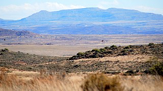
The Great Escarpment is a major topographical feature in Africa that consists of steep slopes from the high central Southern African plateau downward in the direction of the oceans that surround southern Africa on three sides. While it lies predominantly within the borders of South Africa, in the east the escarpment extends northward to form the border between Mozambique and Zimbabwe, continuing on beyond the Zambezi river valley to form the Muchinga Escarpment in eastern Zambia. In the west, it extends northward into Namibia and Angola. It is the combination of this escarpment and the aridity of Southern Africa that leads to the lack of navigable rivers in South Africa.

Golden Gate Highlands National Park is located in Free State, South Africa, near the Lesotho border. It covers an area of 340 km2 (130 sq mi). The park's most notable features are its golden, ochre, and orange-hued, deeply eroded sandstone cliffs and outcrops, especially the Brandwag rock. Another feature of the area is the numerous caves and shelters displaying San rock paintings. Wildlife featured at the park includes mongooses, eland, zebras, and over 100 bird species. It is the Free State's only national park and is more famous for the beauty of its landscape than for its wildlife. Numerous palaeontology finds have been made in the park, including dinosaur eggs and skeletons.

The Pilanesberg is a mountain in the North West Province, South Africa. The mountain is an ancient volcanic structure, circular in shape, that rises from flat surrounding plains. It is formed by three concentric ridges or rings of hills, of which the outermost has a diameter of about 24 km. The Pilanesberg is located 100 km to the North-West of Pretoria and is for the greater part enclosed in a protected area known as Pilanesberg National Park.
The Sneeuberge or Sneeuberg mountain range was historically known as “Sneeuwbergen”, meaning ‘snow mountains’ in Cape Dutch, and refers to a significant portion of Southern Africa's Great Escarpment in the Cradock, Murraysburg, Richmond, Graaff-Reinet, Nieu-Bethesda and Middelburg districts of the Great Karoo, most of which are in the Eastern Cape Province.

The Clarens Formation is a geological formation found in several localities in Lesotho and in the Free State, KwaZulu-Natal, and Eastern Cape provinces in South Africa. It is the uppermost of the three formations found in the Stormberg Group of the greater Karoo Supergroup rocks and represents the final phase of preserved sedimentation of the Karoo Basin.
The Stormberg is a range of mountains situated in the Eastern Cape province of South Africa, are an easterly extension of the Bamboesberge and form an outlier of the greater Drakensberg mountain range. They form part of the 'Amatola and Stormberg' region which includes major towns like Grahamstown, East London and Port Alfred. Towns in the Stormberg Mountains include Sterkstroom, Jamestown, Molteno, Dordrecht, Barkly East, Rhodes and Steynsburg. South Africa's only ski resort, Tiffindell, is also situated in these mountains.

Matatiele Municipality is a local municipality within the Alfred Nzo District Municipality, in the Eastern Cape province of South Africa. It adjoins Lesotho to the north, Elundini to the south-west, and Greater Kokstad to the east and its 4,352 km² makes the Matatiele Municipality largest of four municipalities in the district at almost half of its geographical area. According to the South African National Census of 2011, its 203,483 residents and 49,527 households makes Matatiele Municipality the second largest populated area in the Alfred Nzo District Municipality behind Mbizana.

The Wolkberg is a mountain range in Tzaneen, Limpopo Province, South Africa. It is a northern termination and a subrange of the Drakensberg mountain range which lines up from Eastern Cape, Lesotho, Kwazulu Natal and Mpumalanga. At 2200 m (7200 ft) above sea level, it is the highest mountain range in Limpopo, together with the Iron crown mountain. Its Meteorological significance is that it brings along cold fronts and is a source of cold winters throughout the Limpopo province, the cold front gets transferred from greater Drakensberg mountains in Kwazulu Natal all the way to the Wolkberg. Without the Wolkberg, Limpopo will not experience cold winters at all. The range extends for about 30 km (19 mi) in a NW/SE direction north of Sekhukhuneland. The nearest towns are Haenertsburg and Tzaneen.

The Drakensberg Group is a geological group named after the Drakensberg mountain range where in its uppermost sections the rocks are found. The Drakensberg Group lies over most of Lesotho and localities in the Eastern Cape, KwaZulu-Natal, and Free State provinces of South Africa. It forms part of the greater Karoo Igneous Province, which occurs over an extensive area of southern Africa.