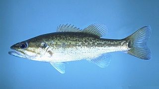
The spotted bass, also called spotty, or spots in various fishing communities, is a species of North American freshwater fish belonging to the sunfish family (Centrarchidae) of the order Perciformes. It is noted for the rows of dark spots below the lateral line, which give it its common name. One of the black basses, it is native to the Mississippi River basin and across the Gulf states, from central Texas through the Florida panhandle. Its native range extends into the western Mid-Atlantic states and it has been introduced into western North Carolina and Virginia. It has also been introduced to southern Africa, where it has become established in some isolated waters as an invasive species.
The Olifants River is a river in the northwestern area of the Western Cape Province of South Africa. The upper and main catchment area of the Olifants river is around Ceres and the Cederberg mountains. The Clanwilliam and Bulshoek dams are located on the river and provide water for the towns and farms along the watercourse. The river is approximately 285 km long with a catchment area of 46,220 km2 and flows into the Atlantic Ocean at Papendorp, 250 km north of Cape Town.

The Great Fish River is a river running 644 kilometres (400 mi) through the South African province of the Eastern Cape. The coastal area between Port Elizabeth and the Fish River mouth is known as the Sunshine Coast. The Great Fish River was originally named Rio do Infante, after João Infante, the captain of one of the caravels of Bartolomeu Dias. Infante visited the river in the late 1480s.

Gamtoos River or Gamptoos River is a river in the Eastern Cape Province, South Africa. It is formed by the confluence of the Kouga River and the Groot River and is approximately 645-kilometre (401 mi) long with a catchment area of 34,635 square kilometres (13,373 sq mi).

The Berg River is a river located just north of Cape Town in the Western Cape Province of South Africa. It is approximately 294 km (183 mi) long with a catchment area of 7,715 km² (2979 mi²) and debouches into the Atlantic Ocean. About 65% of the Berg River area is under agriculture. The major towns in the Berg River area are Velddrif and Laaiplek near the coast, Piketberg, Hopefield, Moorreesburg and Darling further inland.
The Galaxiidae are a family of mostly small freshwater fish in the Southern Hemisphere. The majority live in Southern Australia or New Zealand, but some are found in South Africa, southern South America, Lord Howe Island, New Caledonia, and the Falkland Islands. One galaxiid species, the common galaxias, is probably the most widely naturally distributed freshwater fish in the Southern Hemisphere. They are coolwater species, found in temperate latitudes, with only one species known from subtropical habitats. Many specialise in living in cold, high-altitude upland rivers, streams, and lakes.
Sarah Baartman District Municipality is situated in the western part of the Eastern Cape province, covering an area of 58 242 square kilometres. The area of the district municipality includes seven local municipalities. The seat of Sarah Baartman is the city of Gqeberha, although Gqeberha is not itself in the district. The languages most spoken among the 388,201 people are Xhosa and Afrikaans. The district code is DC10.
Galaxias is a genus of small, highly successful freshwater fish in the family Galaxiidae. They are typically found at temperate latitudes across the Southern Hemisphere and are frequently referred to as galaxiids.

The Cape galaxias is a species of freshwater fish of the family Galaxiidae.

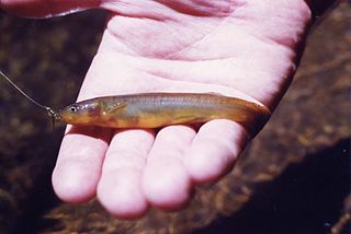
The smallscale redfin is a freshwater fish in the family Cyprinidae which is endemic to South Africa. It is threatened by habitat destruction and the impact of invasive species.

The Kouga Dam is an arch dam on the Kouga River about 21 km (13 mi) west of Patensie in Kouga Local Municipality, South Africa. It supplies irrigation water to the Kouga and Gamtoos valleys as well as drinking water to the Port Elizabeth metropolitan area via the Loerie Balancing Dam. It was constructed between 1957 and 1969.
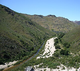
The Baviaanskloof River is a river flowing through the Cape Fold Mountains of the Western Cape and eventually Eastern Cape provinces of South Africa. The river's origin is in the eastern extremity of the Little Karoo, and follows a valley between these mountains eastwards. It ends at a confluence with the Kouga River, some 80 km from its source.

Baviaanskloof Mega Reserve is a protected area in the Eastern Cape Province, South Africa.

The Kouga Local Municipality is located in the Eastern Cape of South Africa, approximately 80 km west of Port Elizabeth, and forms part of the Sarah Baartman District Municipality. Its territory includes the coastal zone between the Van Stadens River in the east and the Tsitsikamma River in the west, and stretches inland towards the Baviaanskloof Mountains in the north.

Kareedouw or Kareedowns is a town in the Eastern Cape province of South Africa. It is the administrative centre for the Kou-Kamma Municipality in the Sarah Baartman District of the Eastern Cape.

The Groot River is a river in the southern area of the Eastern Cape province of South Africa. It is a right hand tributary of the Gamtoos River. This river passes through Steytlerville.

The Albany thickets is an ecoregion of dense woodland in southern South Africa, which is concentrated around the Albany region of the Eastern Cape.
Fish to Tsitsikama WMA, or Fish to Tsitsikama Water Management Area , in South Africa Includes the following major rivers: the Fish River, Kowie River, Boesmans River, Sundays River, Gamtoos River, Kromme River, Tsitsikamma River and Groot River, and covers the following Dams:

The Keurbooms River is a river in the Western Cape Province in South Africa. The river has its sources south of Uniondale in the Langkloof and flows in a roughly southeastern direction. It passes De Vlugt and the Prince Alfred Pass, flowing along the northern side of the R340 road then it turns south. After crossing the N2 road, it flows into the Indian Ocean through the Keurbooms Estuary, located close to the coastal town of Plettenberg Bay.

Krom River or Kromme River is a river in the Eastern Cape Province in South Africa. The river flows into the Indian Ocean through an estuary on the north side of St Francis Bay, west of Port Elizabeth. The Krom river flows in an ESE direction and is approximately 109 km long with a catchment area of 1,085 km2.

