The Baviaanskloof River is a river flowing through the Cape Fold Mountains of the Western Cape and eventually Eastern Cape provinces of South Africa. The river's origin is in the eastern extremity of the Little Karoo, and follows a valley between these mountains eastwards. It ends at a confluence with the Kouga River, some 80km from its source.
It is flanked by the Baviaanskloof Mountains to the north and the Kouga Mountains to the south, and it receives numerous small tributaries from both. Agricultural settlements along the river include Studtis and Sandvlakte. The valley is situated about 35km north of the Langkloof, which is comparable though larger.
Baviaan, meaning baboon, is a translation of the river's original Khoikhoi name, i Ncwama, also believed to mean "baboon". Beutler consequently named the river the Gomee or Baviaans.[2][3]Robert Gordon however named it the Prehns River, in honour of a commander of the Cape garrison.[2]
Fynbos is a small belt of natural shrubland or heathland vegetation located in the Western Cape and Eastern Cape provinces of South Africa. This area is predominantly coastal and mountainous, with a Mediterranean climate and rainy winters. The fynbos ecoregion is within the Mediterranean forests, woodlands, and scrub biome. In fields related to biogeography, fynbos is known for its exceptional degree of biodiversity and endemism, consisting about 80% species of the Cape floral kingdom where nearly 6,000 of them are endemic. This land continues to face severe human-caused threats, but due to the many economic uses of the fynbos, conservation efforts are being made to help restore it.
Gamtoos River or Gamptoos River is a river in the Eastern Cape Province, South Africa. It is formed by the confluence of the Kouga River and the Groot River and is approximately 645-kilometre (401 mi) long with a catchment area of 34,635 square kilometres (13,373 sq mi).
Sarah Baartman District Municipality is situated in the western part of the Eastern Cape province, covering an area of 58 242 square kilometres. The area of the district municipality includes seven local municipalities. The seat of Sarah Baartman is the city of Port Elizabeth, although Port Elizabeth is not itself in the district. The languages most spoken among the 388,201 people are Xhosa and Afrikaans.. The district code is DC10.
The Sundays River or Nukakamma is a river in the Eastern Cape Province of South Africa. It is said to be the fastest flowing river in the country. The Khoisan people originally named this river Nukakamma because the river's banks are always green and grassy despite the arid terrain that it runs through.
The Cape Fold Belt is a fold and thrust belt of late Paleozoic age, which affected the sequence of sedimentary rock layers of the Cape Supergroup in the southwestern corner of South Africa. It was originally continuous with the Ventana Mountains near Bahía Blanca in Argentina, the Pensacola Mountains, the Ellsworth Mountains and the Hunter-Bowen orogeny in eastern Australia. The rocks involved are generally sandstones and shales, with the shales persisting in the valley floors while the erosion resistant sandstones form the parallel ranges, the Cape Fold Mountains, which reach a maximum height of 2325 m at Seweweekspoortpiek.
The Kou-Kamma Municipality is a local municipality in South Africa. It is situated in the southwest corner of the Sarah Baartman District Municipality along the Indian Ocean coastline, in the southwestern sector of South Africa's Eastern Cape Province. To the west lies the Western Cape Province. Kou-Kamma also borders the Dr Beyers Naudé Local Municipality in the north and the Kouga Local Municipality to the east. The geographical area of the Municipality is 12,540 square kilometres. Its name is a blend of the names of the Kouga (Kou-) and Tsitsikamma (-Kamma) mountains, which in turn were named after the rivers Kouga and Tsitsikamma.
The Langkloof is a 160 km long valley in South Africa, lying between Herold, a small village northeast of George, and The Heights - just beyond Twee Riviere.
Eastern Cape Parks are the national parks, marine protected areas, nature reserves and other nature conservation areas in the Eastern Cape province of South Africa. Eastern Cape Parks and Tourism Agency (ECPTA) is the governmental organisation responsible for maintaining wilderness areas and public nature reserves in the Eastern Cape, based in East London.
The R62 is a provincial route in South Africa that connects Ashton with Humansdorp. The R62 runs through the Little Karoo and the Langkloof, passing through Montagu, Ladismith, Calitzdorp, Oudtshoorn, and Joubertina.
Baviaanskloof Mega Reserve is a protected area in the Eastern Cape Province, South Africa.
The Kouga Local Municipality is located in the Eastern Cape of South Africa, approximately 80 km west of Port Elizabeth, and forms part of the Sarah Baartman District Municipality. Its territory includes the coastal zone between the Van Stadens River in the east and the Tsitsikamma River in the west, and stretches inland towards the Baviaanskloof Mountains in the north.
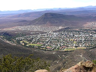
Kareedouw is a town in the Eastern Cape province of South Africa. It is the administrative centre for the Kou-Kamma Municipality in the Sarah Baartman District of the Eastern Cape.
Baviaanskloof Wilderness Area is a protected area in Eastern Cape, South Africa. It is a 174 400 ha Conservation Area recognised in 2004 as a World Heritage Site. The word, Baviaanskloof, is derived from the Dutch "valley of baboons".
Kromme Dam, is a multi-arch type dam located at the Kromme River, near Kareedouw, Eastern Cape, in South Africa. It was established in 1943 and its main purpose is for municipal and industrial usage.
The Kowie River is a river in the Eastern Cape, South Africa. It has its source in the hills of the "Grahamstown Heights" from where it flows in a south-easterly direction draining the major part of the Bathurst region, reaching the Indian Ocean through an estuary at Port Alfred.
The Tarka River is a river in the Eastern Cape, South Africa. Along with the Baviaans River, Grootbrak River and Kat River it is a major eastern tributary of the Great Fish River. The Lake Arthur Dam and the Kommandodrif Dam are located in this river. The latter is included in the Commando Drift Nature Reserve.
The Kraai River is a tributary of the Orange River that flows near Barkly East in the Eastern Cape, South Africa.
The Kouga River originates near Uniondale, Eastern Cape, South Africa, and flows eastward, where it joins the Groot River to form the Gamtoos just past the Kouga Dam. Its main tributary is the Baviaanskloof River, which joins its left bank before the dam.
The Kouga mountains are a mountain range on the border of the Eastern Cape and Western Cape provinces in South Africa, stretching in an east–west direction. They are part of the Cape Fold Belt, beginning just east of Uniondale and stretching further eastwards. The range separates the Baviaanskloof and Langkloof from each other.
Protea vogtsiae, also known as the Kouga sugarbush, is a small flowering shrub of the genus Protea within the family Proteaceae, which is only found growing in the wild in the southern Cape Region of South Africa.
This page is based on this Wikipedia article Text is available under the CC BY-SA 4.0 license; additional terms may apply. Images, videos and audio are available under their respective licenses.


