
The Orange River is a river in Southern Africa. It is the longest river in South Africa. With a total length of 2,432 km (1,511 mi), the Orange River Basin extends from Lesotho into South Africa and Namibia to the north. It rises in the Drakensberg mountains in Lesotho, flowing westwards through South Africa to the Atlantic Ocean. The river forms part of the international borders between South Africa and Lesotho and between South Africa and Namibia, as well as several provincial borders within South Africa. Except for Upington, it does not pass through any major cities. The Orange River plays an important role in the South African economy by providing water for irrigation and hydroelectric power. The river was named the Orange River in honour of the Dutch ruling family, the House of Orange, by the Dutch explorer Robert Jacob Gordon. Other names include simply the word for river, in Khoekhoegowab orthography written as !Garib, which is rendered in Afrikaans as Gariep River with the intrusion of a velar fricative in place of the alveolar click, Groote River or Senqu River, derived from ǂNū "Black".

The Australian grayling is a primarily freshwater fish found in coastal rivers in south-eastern mainland Australia and Tasmania. In past decades it has also been known as the cucumber mullet or cucumber herring, for its cucumber-like odour.
The Olifants River is a river in the northwestern area of the Western Cape Province of South Africa. The upper and main catchment area of the Olifants river is around Ceres and the Cederberg mountains. The Clanwilliam and Bulshoek dams are located on the river and provide water for the towns and farms along the watercourse. The river is approximately 285 km long with a catchment area of 46,220 km2 and flows into the Atlantic Ocean at Papendorp, 250 km north of Cape Town.

The Great Kei River is a river in the Eastern Cape province of South Africa. It is formed by the confluence of the Black Kei River and White Kei River, northeast of Cathcart. It flows for 320 km (199 mi) and ends in the Great Kei Estuary at the Indian Ocean with the small town Kei Mouth on the west bank. Historically the Great Kei River formed the southwestern border of the Transkei region as was formerly known as the Nciba River.

The Great Fish River is a river running 644 kilometres (400 mi) through the South African province of the Eastern Cape. The coastal area between Port Elizabeth and the Fish River mouth is known as the Sunshine Coast. The Great Fish River was originally named Rio do Infante, after João Infante, the captain of one of the caravels of Bartolomeu Dias. Infante visited the river in the late 1480s.

Gamtoos River or Gamptoos River is a river in the Eastern Cape Province, South Africa. It is formed by the confluence of the Kouga River and the Groot River and is approximately 645-kilometre (401 mi) long with a catchment area of 34,635 square kilometres (13,373 sq mi).

The Berg River is a river located just north of Cape Town in the Western Cape Province of South Africa. It is approximately 294 km (183 mi) long with a catchment area of 7,715 km² (2979 mi²) and debouches into the Atlantic Ocean. About 65% of the Berg River area is under agriculture. The major towns in the Berg River area are Velddrif and Laaiplek near the coast, Piketberg, Hopefield, Moorreesburg and Darling further inland.
The Galaxiidae are a family of mostly small freshwater fish in the Southern Hemisphere. The majority live in Southern Australia or New Zealand, but some are found in South Africa, southern South America, Lord Howe Island, New Caledonia, and the Falkland Islands. One galaxiid species, the common galaxias, is probably the most widely naturally distributed freshwater fish in the Southern Hemisphere. They are coolwater species, found in temperate latitudes, with only one species known from subtropical habitats. Many specialise in living in cold, high-altitude upland rivers, streams, and lakes.
Galaxias is a genus of small, highly successful freshwater fish in the family Galaxiidae. They are typically found at temperate latitudes across the Southern Hemisphere and are frequently referred to as galaxiids.

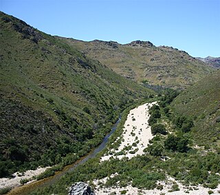
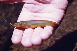
The Cape galaxias is a species of freshwater fish of the family Galaxiidae.

Spotted galaxias is a largish, primarily-freshwater galaxias species found in southern Australia. Spotted galaxias are perhaps the most beautiful of the Australian galaxias species. They are a somewhat tubular, deep-bodied fish, with a dusky brownish-red colouration overlain with dark, haloed spots, dramatic black edges to dorsal, anal and pelvic fins, and a dark diagonal stripe through the eye.

The Knysna seahorse or Cape seahorse is a species of fish in the family Syngnathidae. It is endemic to the south coast of South Africa, where it has been found in only three brackish water habitats: the estuary of the Keurbooms River in Plettenberg Bay, the Knysna Lagoon, and the estuarine portion of the Swartvlei system in Sedgefield. The limited range of this seahorse puts it at great risk of extinction.

Palmiet River is a river located in the Western Cape province of South Africa. The Palmiet River is a typical Western Cape river, experiencing winter rainfall and it is important for the Western Cape Water Supply System. It has a small catchment area of 500 km2, flows through the expanse of the Elgin Valley, and reaches the ocean through an estuary.

The Kouga River originates near Uniondale, Eastern Cape, South Africa, and flows eastward, where it joins the Groot River to form the Gamtoos just past the Kouga Dam. Its main tributary is the Baviaanskloof River, which joins its left bank before the dam.

Velddrif(The Town) or Velddrift(The farm on which it was established), is a coastal fishing town in the Bergrivier Local Municipality, Western Cape, South Africa. It is located on the estuary where the Berg River flows into St. Helena Bay.
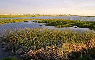
The Rietvlei Wetland Reserve is a 663-hectare (1,640-acre) nature reserve situated in Table View, Western Cape, South Africa. It is managed by the City of Cape Town's Environmental Resource Management Department.

Mzimvubu River or Umzimvubu River is one of the most important rivers in South Africa. It is located in the Eastern Cape Province.

Krom River or Kromme River is a river in the Eastern Cape Province in South Africa. The river flows into the Indian Ocean through an estuary on the north side of St Francis Bay, west of Port Elizabeth. The Krom river flows in an ESE direction and is approximately 109 km long with a catchment area of 1,085 km2.

Mbhashe River, Mbashe River or Bashee River is one of the major rivers in the Eastern Cape Province, South Africa. It flows in a southeastern direction and has a catchment area of 6,030 km2. The river drains into the Indian Ocean through an estuary located near the lighthouse at Bashee, south of Mhlanganisweni.
The Broadmeadow River or Broad Meadow Water, is a river of County Meath and northern County Dublin, about 25 kilometres (16 mi) long. It opens into a wide estuary between Swords and Malahide, and reaches the open sea several kilometres downstream, north of Malahide village. One of the larger watercourses by volume in the Dublin Region, the Broadmeadow is a salmonid river, with several species of fish, including brown trout. It has many small, and a few larger, tributaries, notably the Ward River. It is under the responsibility of Meath County Council and Fingal County Council, as well as oversight of the Environmental Protection Agency.


