
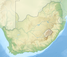
South Africa occupies the southern tip of Africa, its coastline stretching more than 2,850 kilometres from the desert border with Namibia on the Atlantic (western) coast southwards around the tip of Africa and then northeast to the border with Mozambique on the Indian Ocean. The low-lying coastal zone is narrow for much of that distance, soon giving way to a mountainous escarpment that separates the coast from the high inland plateau. In some places, notably the province of KwaZulu-Natal in the east, a greater distance separates the coast from the escarpment. Although most of the country is classified as semi-arid, it has considerable variation in climate as well as topography. The total land area is 1,220,813 km2 (471,359 sq mi). It has the 23rd largest Exclusive Economic Zone of 1,535,538 km2 (592,875 sq mi).

The Drakensberg is the eastern portion of the Great Escarpment, which encloses the central Southern African plateau. The Great Escarpment reaches its greatest elevation – 2,000 to 3,482 metres within the border region of South Africa and Lesotho.

Tzaneen is a large tropical garden town situated in the Mopani District Municipality of the Limpopo province in South Africa. It is situated in a high rainfall fertile region with tropical and subtropical agriculture taking place in a 20,000 km2 region. It is Limpopo's second largest town after Polokwane.
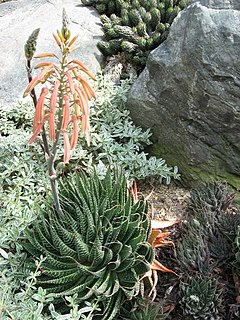
Aristaloe is a genus of evergreen flowering perennial plants in the family Asphodelaceae from Southern Africa. Its sole species is Aristaloe aristata, known as guinea-fowl aloe or lace aloe.

The Kwazulu-Cape coastal forest mosaic is a subtropical moist broadleaf forest ecoregion of South Africa. It covers an area of 17,800 square kilometers (6,900 sq mi) in South Africa's Eastern Cape and KwaZulu-Natal provinces.

The Great Escarpment is a major topographical feature in Africa that consists of steep slopes from the high central Southern African plateau downward in the direction of the oceans that surround southern Africa on three sides. While it lies predominantly within the borders of South Africa, in the east it extends northward to form the border between Mozambique and Zimbabwe, continuing on beyond the Zambezi River valley to form the Muchinga Escarpment in eastern Zambia. In the west, it extends northward into Namibia and Angola.
Lepidochrysops lotana, the Lotana blue, is a species of butterfly in the family Lycaenidae. It is endemic to South Africa, where it is only known from two localities in the Limpopo province, the western slope of the Ysterberg and from Moria to Serala Forest in the Wolkberg area.

The Motlatse River, Blyde River, or Umdhlazi River is a river in the Mpumalanga and Limpopo provinces of South Africa. It has a northwards course in steep-sided valleys and ravines of the Mpumalanga Drakensberg, before it enters the lowveld region of the Limpopo province. It has its ultimate origins at around 2,000 m altitude in the Hartebeesvlakte conservation area, to the north of Long Tom Pass. It runs through the Blyde River Canyon.

The Ga-Selati River or Selati River is a river in Limpopo, South Africa.

The Maputaland-Pondoland-Albany Hotspot (MPA) is a biodiversity hotspot, a biogeographic region with significant levels of biodiversity, in Southern Africa. It is situated near the south-eastern coast of Africa, occupying an area between the Great Escarpment and the Indian Ocean. The area is named after Maputaland, Pondoland and Albany. It stretches from the Albany Centre of Plant Endemism in the Eastern Cape Province of South Africa, through the Pondoland Centre of Plant Endemism and KwaZulu-Natal Province, the eastern side of Eswatini and into southern Mozambique and Mpumalanga. The Maputaland Centre of Plant Endemism is contained in northern KwaZulu-Natal and southern Mozambique.
Acraea alalonga, the long-winged orange acraea, is a butterfly of the family Nymphalidae. It is found in montane grassland from the Drakensberg and midlands in KwaZulu-Natal, north into Mpumalanga and the Wolkberg in Limpopo.

Iolaus silarus, the straight-line sapphire, is a butterfly of the family Lycaenidae. The species was first described by Hamilton Herbert Druce in 1885. It is found in Mozambique, Zimbabwe, Botswana, Namibia, Malawi, Zambia, southern Zaire, Tanzania, south-western Kenya and South Africa. In South Africa it is found in wooded savannah in northern KwaZulu-Natal and in savannah from Eswatini to Mpumalanga, Limpopo and North West. It is also present in Afromontane forest on the Wolkberg and the northern Drakensberg.

Aloeides dryas, the Transvaal copper, is a butterfly of the family Lycaenidae. It is found in southern Africa, where it is known from northern KwaZulu-Natal, Swaziland and Mpumalanga, and along the Drakensberg to the Wolkberg range in Limpopo province.
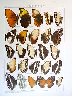
Cymothoe alcimeda, the battling glider, is a butterfly of the family Nymphalidae. It is found in South Africa and Zimbabwe.

The Wolkberg Wilderness Area is a protected area in Limpopo Province, South Africa. It is located in the Wolkberg, a subrange of the Drakensberg approximately 14 kilometres (8.7 mi) south-east of Haenertsburg and 60 kilometres (37 mi) east of Polokwane. The 2,127 metres (6,978 ft) high Ysterkroon and the surrounding 22,000 hectares was proclaimed a Wilderness Area in 1977.

South Africa has an emerging aquaculture. It consists mainly of culture of freshwater species such as crocodiles, trout, catfish, tilapia and ornamental fish as well as marine species such as abalone, prawns, oysters and mussels.
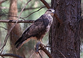
The forest buzzard, is a species of bird of prey found in Africa, though some authorities have placed it as a subspecies of another species, the mountain buzzard, Buto oreophilus. This is a resident breeding species in woodlands in southern and eastern South Africa.

Mariepskop, at 1,947 m above sea level, is one of the highest peaks in the northern Drakensberg, and the highest point of the Blyde River Canyon, South Africa. It is situated at the junction of three conservation areas, namely the Mariepskop Forest Reserve, Mariepskop State Forest, and the Blyde River Canyon Nature Reserve. The mountain is bordered by sheer cliff faces on several sides, and is composed of Proterozoic sedimentary rocks of the Transvaal Supergroup. It is named for the 19th century Pulana chief, Maripe Mashile, whose tribe used the mountain as a stronghold. Some infrastructure and roads were built in the 1950s to service a military radar station. Mariepskop is flanked by Tshwateng (1,628 m) at the opposite side of the Blyde River, and by Hebronberg (1,767 m) in the south.

Lekgalameetse Provincial Park is a conserved mountain wilderness of 18,718 ha, situated west of Ofcolaco and Trichardtsdal in the northern Drakensberg of Limpopo Province, South Africa. It was envisaged by the Lebowa government during the 1980s as a 25,000 ha reserve called The Downs Nature Reserve, which would cater recreational activities, camping and hiking. Current amenities include self-catering accommodation, a bush camp with log cabins beside a stream, farmhouses serving as guest houses, and a camp for school outings.

