The Blue Ridge Mountains are a physiographic province of the larger Appalachian Mountains range. The mountain range is located in the eastern United States, and extends 550 miles southwest from southern Pennsylvania through Maryland, West Virginia, Virginia, North Carolina, South Carolina, Tennessee, and Georgia. This province consists of northern and southern physiographic regions, which divide near the Roanoke River gap. To the west of the Blue Ridge, between it and the bulk of the Appalachians, lies the Great Appalachian Valley, bordered on the west by the Ridge and Valley province of the Appalachian range.

Dordrecht is a town situated in the Eastern Cape Province of South Africa. Dordrecht was founded in 1856 by Baron Smiddolff, a minister of the Dutch Reformed Church. The town was named for the city of the same name in the South-Western Netherlands and had a population of about 8,741 people in 2001.

The Taconic Mountains or Taconic Range are a range of the Appalachian Mountains, running along the eastern border of New York State and adjacent New England from northwest Connecticut to western Massachusetts, north to central western Vermont. A physiographic region of the larger New England province, the range includes notable summits, including its high point, 3,840 feet (1,170 m) Mount Equinox in Vermont, and 3,489 feet (1,063 m) Mount Greylock, the highest point in Massachusetts.

Clarens is a small town situated in the foothills of the Maluti Mountains in the Free State province of South Africa and nicknamed the "Jewel of the Eastern Free State". It was established in 1912 and named after the town of Clarens in Switzerland where exiled Paul Kruger spent his last days. It is situated 336 km from Johannesburg, 284 km from Bloemfontein, 389 km from Durban.

Melanorosaurus is a genus of basal sauropodomorph dinosaur that lived during the Late Triassic period. A herbivore from South Africa, it had a large body and sturdy limbs, suggesting it moved about on all fours. Its limb bones were massive and weighty, like sauropod limb bones.

Euskelosaurus is a plateosaurid sauropodomorph dinosaur from the Late Triassic of South Africa and Lesotho. Fossils have only been recovered from the lower Elliot Formation in South Africa and Lesotho, and in one locality in Zimbabwe.
Gryponyx is an extinct genus of massopod sauropodomorph known from southern Free State, central South Africa.
Orosaurus is a dubious genus of basal sauropodomorph from the Late Triassic of South Africa.

The Karoo Supergroup is the most widespread stratigraphic unit in Africa south of the Kalahari Desert. The supergroup consists of a sequence of units, mostly of nonmarine origin, deposited between the Late Carboniferous and Early Jurassic, a period of about 120 million years.

The Clarens Formation is a geological formation found in several localities in Lesotho and in the Free State, KwaZulu-Natal, and Eastern Cape provinces in South Africa. It is the uppermost of the three formations found in the Stormberg Group of the greater Karoo Supergroup rocks and represents the final phase of preserved sedimentation of the Karoo Basin.

The Molteno Formation is a geological formation found in several localities in Lesotho and South Africa. It lies mainly south of Maseru, near Burgersdorp, Aliwal North, Dordrecht, Molteno, and Elliot. It extends as far north as Matatiele in the Eastern Cape. The formation's localities lie along the Drakensberg Mountains in Kwazulu-Natal, and near Ladybrand in the Free State of South Africa. The Molteno Formation is the lowermost of the three formations in the Stormberg Group of the greater Karoo Supergroup. The Molteno Formation represents the initial phase of preserved sedimentation of the Stormberg Group.

Molteno is a town in the Eastern Cape province of South Africa.

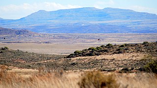
The Stormberg is a range of mountains situated in the Eastern Cape province of South Africa, are an easterly extension of the Bamboesberge and form an outlier of the greater Drakensberg mountain range. They form part of the 'Amatola and Stormberg' region which includes major towns like Grahamstown, East London and Port Alfred. Towns in the Stormberg Mountains include Sterkstroom, Jamestown, Molteno, Dordrecht, Barkly East, Rhodes and Steynsburg. South Africa's only ski resort, Tiffindell, is also situated in these mountains.

The Stormberg Group is one of the four geological groups that comprises the Karoo Supergroup in South Africa. It is the uppermost geological group representing the final phase of preserved sedimentation of the Karoo Basin. The Stormberg Group rocks are considered to range between Lower Triassic (Olenekian) to Lower Jurassic (Pliensbachian) in age. These estimates are based on means of geological dating including stratigraphic position, lithostratigraphic and biostratigraphic correlations, and palynological analyses.

Hofmeyr is a small Karoo town in the Eastern Cape Province of South Africa, 20 km west of the Bamboesberg mountain range. It lies 64 km north-east of Cradock at an altitude of 1,252 metres. According to the 2011 census, the population of Hofmeyr proper is about 326 persons and the neighbouring township of Luxolweni is about 3354. In former times it lay at the centre of a flourishing sheep-farming district and managed some salt pans 10 km to its west.

The Cape Government Railways 4th Class 4-6-0TT of 1884 was a South African steam locomotive from the pre-Union era in the Cape of Good Hope.

The Drakensberg Group is a geological group named after the Drakensberg mountain range where in its uppermost sections the rocks are found. The Drakensberg Group lies over most of Lesotho and localities in the Eastern Cape, KwaZulu-Natal, and Free State provinces of South Africa. It forms part of the greater Karoo Igneous Province, which occurs over an extensive area of southern Africa.


