Steynsburg | |
---|---|
Coordinates: 31°17′47″S25°49′22″E / 31.29639°S 25.82278°E | |
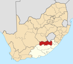
Country | South Africa |
Province | Eastern Cape |
District | Joe Gqabi |
Municipality | Walter Sisulu |
Government | |
• Type | Local Municipality |
• Councillor | (ANC) |
Area | |
• Total | 17.4 km2 (6.7 sq mi) |
Elevation | 1,450 m (4,760 ft) |
Population (2011) [1] | |
• Total | 7,212 |
• Density | 410/km2 (1,100/sq mi) |
Racial makeup (2011) | |
• Black African | 80.5% |
• Coloured | 14.7% |
• Indian/Asian | 0.2% |
• White | 3.9% |
• Other | 0.6% |
First languages (2011) | |
• Xhosa | 74.4% |
• Afrikaans | 20.5% |
• English | 1.8% |
• Sotho | 1.0% |
• Other | 2.4% |
Time zone | UTC+2 (SAST) |
Postal code (street) | 5920 |
PO box | 5920 |
Area code | 048 |
Steynsburg is a small town in the Walter Sisulu Local Municipality of the Joe Gqabi District Municipality, Eastern Cape province of South Africa. Steynsburg is located on the intersection of the R56 and R390.
The town lies 64 kilometres (40 mi) south-west of Burgersdorp and 48 kilometres (30 mi) north of Hofmeyr. It developed around the Reformed Church established in 1872 and has been administered by a village management board since 1874. Steynsburg is named after Douwe Gerbrandt Steyn, grandfather of President Paul Kruger. [2]
Steynsburg has a well-established Provincial hospital. [3]
The Eastern Cape is one of the nine provinces of South Africa. Its capital is Bhisho, but its two largest cities are East London and Gqeberha.
Paarl is a town with 285,574 inhabitants in the Western Cape province of South Africa. It is the third-oldest city and European settlement in the Republic of South Africa and the largest town in the Cape Winelands. Due to the growth of the Mbekweni township, it is now a de facto urban unit with Wellington. It is situated about 60 kilometres (37 mi) northeast of Cape Town in the Western Cape Province and is known for its scenic environment and viticulture and fruit-growing heritage.
Stellenbosch is a town in the Western Cape province of South Africa, situated about 50 kilometres east of Cape Town, along the banks of the Eerste River at the foot of the Stellenbosch Mountain. The town became known as the City of Oaks or Eikestad in Afrikaans and Dutch due to the large number of oak trees that were planted by its founder, Simon van der Stel, to grace the streets and homesteads.
The R56 is a provincial route in South Africa that connects Middelburg with Pietermaritzburg via Molteno, Maclear and Kokstad. It is co-signed with the N2 between Kokstad and Stafford's Post for 39 kilometres.
Makhanda, also known as Grahamstown, is a town of about 140,000 people in the Eastern Cape province of South Africa. It is situated about 110 kilometres (70 mi) northeast of Gqeberha and 130 kilometres (80 mi) southwest of East London. It is the largest town in the Makana Local Municipality, and the seat of the municipal council. It also hosts Rhodes University, the Eastern Cape Division of the High Court, the South African Library for the Blind (SALB), a diocese of the Anglican Church of Southern Africa, and 6 South African Infantry Battalion. Furthermore, located approximately 3 km south-east of the town lies the world renowned Waterloo Farm, the only estuarine fossil site in the world from 360 million years ago with exceptional soft-tissue preservation.
Somerset West is a town in the Western Cape, South Africa. Organisationally and administratively it is included in the City of Cape Town metropolitan municipality as a suburb of the Helderberg region . The vehicle registration code for Somerset West is CFM and the post code is 7130 for street addresses, and 7129 for post office boxes.
Malmesbury is a town of approximately 36,000 inhabitants in the Western Cape province of South Africa, about 65 km north of Cape Town.
Caledon is a town in the Overberg region in the Western Cape province of South Africa, located about 100 kilometres (62 mi) east of Cape Town next to mineral-rich hot springs. As of 2011 it had a population of 13,020. It is located in, and the seat of, the Theewaterskloof Local Municipality.
Bredasdorp is a town in the Southern Overberg region of the Western Cape, South Africa, and the main economic and service hub of that region. It lies on the northern edge of the Agulhas Plain, about 160 kilometres (100 mi) south-east of Cape Town and 35 kilometres (22 mi) north of Cape Agulhas, the southernmost tip of Africa.
Moorreesburg is a rural town situated about 90 kilometres (60 mi) north of Cape Town, in the Western Cape province of South Africa. It was laid out in 1879 on the farm Hooikraal, was administered by a village management board from 1882 and attained municipal status in 1909. Today it falls within the Swartland Local Municipality, which is part of the West Coast District Municipality. The town is the seat of government for the West Coast District Municipality.
Whittlesea is a semi-rural town situated in the Hewu district, 37 km south of Queenstown, Eastern Cape Province, South Africa. The town is made up of the townships Ekuphumleni, Bhede, Extension 4, Extension 5 and Sada. The town falls under the Enoch Mgijima Local Municipality which is under the Chris Hani District Municipality. Surrounding Whittlesea are 36 villages which make up the Hewu district.
Cookhouse is a small village located in Eastern Cape province, South Africa, some 170 kilometres (110 mi) north of Port Elizabeth and 24 kilometres (15 mi) east of Somerset East, on the west bank of the Great Fish River.
Burgersdorp is a medium-sized town in Walter Sisulu in the Joe Gqabi District Municipality of the Eastern Cape province of South Africa.
Wolseley is a small town in the upper Breede River Valley region of the Western Cape province of South Africa. In the 2011 Census it had a population of 1,528 people. It is located 90 kilometres (60 mi) northeast of Cape Town, in the Land van Waveren valley between the Waterval Mountains to the west and the Witzenberg Mountains to the east.
Port St. Johns is a town of about 6,500 people on the Wild Coast in the Eastern Cape province of South Africa. It is situated at the mouth of the Umzimvubu River, 220 kilometres (140 mi) northeast of East London and 70 kilometres (40 mi) east of Mthatha. Port St. Johns was the Birthplace of Capital Radio 604.
Enon is a small town in the Eastern Cape in South Africa. It is named after the biblical place mentioned in John 3:23 It lies 13 kilometres (8.1 mi) east of Kirkwood and 60 kilometres (37 mi) north-east of Uitenhage.
Qamata is a small town in Intsika Yethu Municipality, Chris Hani District, Eastern Cape Province, South Africa. From 1963 to 1994 it was part of the semi-autonomous Transkei, and before that of western Tembuland. Qamata is located on Route R61 and on the Qamata River. It is 18 kilometres (11 mi) west of the town of Cofimvaba, 39 kilometres (24 mi) east of the R61 junction with Route N6 and 58 kilometres (36 mi) east of Queenstown.
Pearston is a small town in the eastern Karoo, in the Eastern Cape province of South Africa. It lies between Graaff-Reinet and Somerset East at the foot of the Coetzeesberge, about 160 kilometres (100 mi) north of Port Elizabeth. It falls within the Blue Crane Route Local Municipality and has a population of approximately 4,500 people.
Steynsdorp, officially eMlondozi, is a settlement in Gert Sibande District Municipality in the Mpumalanga province of South Africa.
Komga is a town in Amatole District Municipality in the Eastern Cape province of South Africa.
Media related to Steynsburg at Wikimedia Commons