The Province of the Cape of Good Hope, commonly referred to as the Cape Province and colloquially as The Cape, was a province in the Union of South Africa and subsequently the Republic of South Africa. It encompassed the old Cape Colony, as well as Walvis Bay, and had Cape Town as its capital. In 1994, the Cape Province was divided into the new Eastern Cape, Northern Cape and Western Cape provinces, along with part of the North West.

The Orange River is a river in Southern Africa. It is the longest river in South Africa. With a total length of 2,432 km (1,511 mi), the Orange River Basin extends from Lesotho into South Africa and Namibia to the north. It rises in the Drakensberg mountains in Lesotho, flowing westwards through South Africa to the Atlantic Ocean. The river forms part of the international borders between South Africa and Lesotho and between South Africa and Namibia, as well as several provincial borders within South Africa. Except for Upington, it does not pass through any major cities. The Orange River plays an important role in the South African economy by providing water for irrigation and hydroelectric power. The river was named the Orange River in honour of the Dutch ruling family, the House of Orange, by the Dutch explorer Robert Jacob Gordon. Other names include simply the word for river, in Khoekhoegowab orthography written as !Garib, which is rendered in Afrikaans as Gariep River with the intrusion of a velar fricative in place of the alveolar click, Groote River or Senqu River, derived from ǂNū "Black". It is known in isiZulu as isAngqu
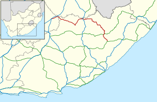
The R58 is a provincial route in South Africa that connects Colesberg with Ngcobo via Aliwal North, Barkly East and Khowa.

Port Elizabeth, officially renamed Gqeberha and colloquially often referred to as P.E., is a major seaport and the most populous city in the Eastern Cape province of South Africa. It is the seat of the Nelson Mandela Bay Metropolitan Municipality, South Africa's second-largest metropolitan district by area size. It is the sixth-most-populous city in South Africa and is the cultural, economic and financial centre of the Eastern Cape.

The Gariep Dam is located in South Africa, near the town of Norvalspont, bordering the Free State and Eastern Cape provinces. Its primary purpose is for irrigation, domestic and industrial use as well as for power generation.
Xhariep is one of the 5 districts of Free State province of South Africa.The District is the largest in the Free State Geographically and is known for its vast land. The District is home to the largest dam in the Country, the Gariep Dam and has two mines,situated in Jagersfontein and Koffifontein. The natural resources and the geographical position of the District make it a site with the best potential for investment and development. Xhariep has prominent towns such as Rouxville. The seat of Xhariep is Trompsburg. The largest language group is Sotho who make up 45.3% of the total population of 146,259. The district code is DC16.
Qubudile Richard Dyantyi is a previous MEC for Local Government and Housing in the Western Cape province of South Africa. He is a member of the African National Congress.

The Orange–Fish Tunnel is a 82.8 kilometres long irrigation tunnel in central South Africa, built to divert water from the Orange River to the Fish River valley. It is the longest continuous enclosed aqueduct in the southern hemisphere.
Oviston is a settlement in Walter Sisulu Local Municipality in Joe Gqabi District Municipality in the Eastern Cape province of South Africa.
Oviston Nature Reserve is a protected area in the Eastern Cape Province, South Africa. The nature reserve is managed by Eastern Cape Parks. It is located on the southern shores of the Gariep Dam.

Burgersdorp is a medium-sized town in Walter Sisulu in the Joe Gqabi District Municipality of the Eastern Cape province of South Africa.
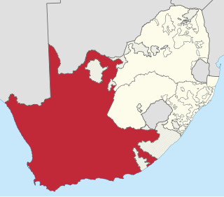
Gariep Local Municipality is a defunct local municipality in Joe Gqabi District Municipality, Eastern Cape. The municipality was merged with Maletswai Local Municipality immediately after the August 2016 Local Municipal Elections to form the new Walter Sisulu Local Municipality.
Steynsburg is a small town in the Walter Sisulu Local Municipality of the Joe Gqabi District Municipality, Eastern Cape province of South Africa. Steynsburg is located on the intersection of the R56 and R390.

Matatiele Local Municipality is a Category B municipality located in the Alfred Nzo District of Eastern Cape in South Africa. It adjoins Lesotho to the north, Elundini to the south-west, and Greater Kokstad to the east and its 4,352 km² makes the Matatiele Local Municipality largest of four municipalities in the district at almost half of its geographical area. [1]

Maletswai Local Municipality is a now defunct administrative area in the Joe Gqabi District of the Eastern Cape in South Africa. The municipality was merged with Gariep Local Municipality immediately after the August 2016 Local Municipal Elections to form the new Walter Sisulu Local Municipality.
Sterkstroom is a settlement in Enoch Mgijima Local Municipality of the Chris Hani District in the Eastern Cape province of South Africa.
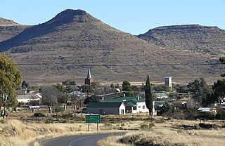
Norvalspont is a small town in Pixley ka Seme District Municipality in the Northern Cape province of South Africa. The name is Afrikaans for Norval’s ferry, and named after an enterprising Scot who constructed a ferry here in 1848. The settlement lies some 40 km east-north-east of Colesberg and 43 km west-north-west of Venterstad, on the southern bank of the Orange River, just below the Gariep Dam.

Gariep Dam, founded as "Oranjekrag", is a settlement in Xhariep District Municipality in the Free State (province) of South Africa.

Walter Sisulu Local Municipality is an administrative area in the Joe Gqabi District of the Eastern Cape in South Africa. The municipality was formed by the merging of Maletswai and Gariep Local Municipality immediately after the August 2016 Local Municipal Elections.


