
Lesotho is a mountainous, landlocked country located in Southern Africa. It is an enclave, surrounded by South Africa. The total length of the country's borders is 909 kilometres (565 mi). Lesotho covers an area of around 30,355 square kilometres (11,720 sq mi), of which a negligible percentage is covered with water.

The Orange River is a river in Southern Africa. It is the longest river in South Africa. With a total length of 2,432 km (1,511 mi), the Orange River Basin extends from Lesotho into South Africa and Namibia to the north. It rises in the Drakensberg mountains in Lesotho, flowing westwards through South Africa to the Atlantic Ocean. The river forms part of the international borders between South Africa and Lesotho and between South Africa and Namibia, as well as several provincial borders within South Africa. Except for Upington, it does not pass through any major cities. The Orange River plays an important role in the South African economy by providing water for irrigation and hydroelectric power. The river was named the Orange River in honour of the Dutch ruling family, the House of Orange, by the Dutch explorer Robert Jacob Gordon. Other names include simply the word for river, in Khoekhoegowab orthography written as !Garib, which is rendered in Afrikaans as Gariep River with the intrusion of a velar fricative in place of the alveolar click, Groote River or Senqu River, derived from ǂNū "Black". It is known in isiZulu as isAngqu.

The Eastern Cape is one of the nine provinces of South Africa. Its capital is Bhisho, and its largest city is Gqeberha. Due to its climate and nineteenth-century towns, it is a common location for tourists. It is also known for having been home to many anti-apartheid activists, including Nelson Mandela.

Mokhotlong district is a district of Lesotho. It includes the highest terrain in the Maloti Mountains and the source of the Senqu River, Lesotho's primary watershed. Mokhotlong is the capital or camptown, and only town in the district. Mokhotlong borders on the KwaZulu-Natal Province of South Africa, with its north point bordering the Free State Province. Domestically, it borders on Butha-Buthe District in northwest, Leribe District in west, and Thaba-Tseka District in the south.
Mokhotlong is a constituency, city and seat of Mokhotlong District in the mountainous northeastern part of Lesotho. It is the first major city with an airport along the road from South Africa across the Sani Pass, near the Maloti Mountains. The name of the city is named in Sesotho, the language of the people of Lesotho, meaning "Place of the Bald Ibis." Thabana Ntlenyana, the highest point in southern Africa, is found in Mokhotlong.

Qacha's Nek is a constituency and, since 1888, the camptown (capital) of Qacha's Nek District in Lesotho, only two kilometers from the South African border at 1,980 meters (6,500 ft) above sea level. It has a population of approximately 15,900 (2016). It is home to Machabeng Government Hospital, one of the two hospitals in the district.
Kokstad is a town in the Harry Gwala District Municipality of KwaZulu-Natal Province, South Africa. Kokstad is named after the Griqua chief Adam Kok III who settled here in 1863. Kokstad is the capital town of the East Griqualand region, as it is also the biggest town in this region. It was built around Mount Currie, a local mountain range, by the town’s founder Adam Kok III, for whom the town is named. Stad is the Dutch and Afrikaans word for "city".

oThongathi, previously and still commonly known as Tongaat, is a town in KwaZulu-Natal, South Africa, about 40 kilometres (25 mi) north of Durban and 28 kilometres (17 mi) south of KwaDukuza. It now forms part of eThekwini Metropolitan Municipality, or the Greater Durban area. The area is home to the oldest Indian community in South Africa, having been where the first indentured Indian laborers settled in 1860 to work in the sugar-cane plantations. Much of the architectural style in the town was the work of Ivan Mitford-Barberton, and many buildings are in the Cape Dutch style of architecture.

The Lesotho Highlands Water Project (LHWP) is an ongoing water supply project with a hydropower component, developed in partnership between the governments of Lesotho and South Africa. It comprises a system of several large dams and tunnels throughout Lesotho and delivers water to the Vaal River System in South Africa. In Lesotho, it involves the rivers Malibamatso, Matsoku, Senqunyane, and Senqu. It is the Africa's largest water transfer scheme.

Teyateyaneng is a town located in the district of Berea in Lesotho. Usually abbreviated to T.Y., Teyateyaneng takes its name from the two twin rivers which run on the north and the South. Both rivers lead to the Mohokare, or the Caledon River which forms the western boundary with South Africa. They are both named for their vast quantities of sand which means rapid dipping of feet as one crosses them, leading to both names which may well suggest that this is a 'place of quick sands'. Teyateyaneng's name therefore comes from the southern Teja-tejana River, but the name later changed to Teyateyaneng, perhaps due to British influences as the country became a Protectorate in the late 1800s.

Barkly East is a town in Eastern Cape Province, South Africa, seat of the Joe Gqabi District Municipality, and 117 km by road E.S.E. of Aliwal North, lying in the mountainous area just south of Lesotho. The town lies at the southern tip of the Drakensberg on the Langkloofspruit, a tributary of the Kraai River which, in turn is a tributary of the Orange River at an elevation of 1 790 meter above sealevel. Barkly East is characterized by rugged mountains and green valleys. Snow falls in winter, and the hamlet of Rhodes is 60 km or an hour's drive from Barkly East on the R396. Both are within the boundaries of the Senqu Local Municipality.

The Maloti Mountains are a mountain range of the highlands of the Kingdom of Lesotho. They extend for about 100 km into the South African Free State. The Maloti Range is part of the Drakensberg system that includes ranges across large areas of South Africa. "Maloti" is also the plural for Loti, the currency of the Kingdom of Lesotho. The range forms the northern portion of the boundary between the Butha-Buthe District in Lesotho and South Africa's Free State.

Lady Grey is a rural village in the North of the Eastern Cape in South Africa near the border with Lesotho. It is situated in the foothills of the Witteberg mountains, 54 km (34 mi) due east of Aliwal North on the R58 road and 260 km (160 mi) from the capital of the Free State Province, Bloemfontein.

Bushbuckridge Municipality is a local municipality within the Ehlanzeni District Municipality, in the Mpumalanga province of South Africa. Commercial farming, which consists of pine and bluegum plantations, tobacco, cotton, sub-tropical fruits and vegetables, is practised in the municipality's countryside. The municipality includes the southern part of Kruger National Park. Bushbuckridge is the largest local municipality in Mpumalanga in terms of land size.

Matatiele Municipality is a local municipality within the Alfred Nzo District Municipality, in the Eastern Cape province of South Africa. It adjoins Lesotho to the north, Elundini to the south-west, and Greater Kokstad to the east and its 4,352 km² makes the Matatiele Municipality largest of four municipalities in the district at almost half of its geographical area. According to the South African National Census of 2011, its 203,483 residents and 49,527 households makes Matatiele Municipality the second largest populated area in the Alfred Nzo District Municipality behind Mbizana.
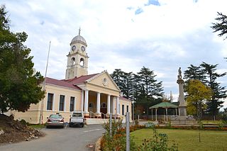
Dihlabeng Municipality is a local municipality within the Thabo Mofutsanyane District Municipality, in the Free State province of South Africa. It was established after the first general local government elections on 5 December 2000, which heralded the final phase of local government reform as envisaged in 1994 at the onset of the process of democratisation and the end of apartheid. The seat is Bethlehem.

Qumbu is a town in OR Tambo District Municipality in the Eastern Cape province of South Africa.
Empilisweni District Hospital is a Provincial government funded hospital for the Senqu Local Municipality area in Sterkspruit, Eastern Cape in South Africa. Empilisweni is a level 1 hospital situated near the Lesotho and Free State borders with 93 usable beds. It forms a cluster with Umlamli Hospital, Lady Grey and Cloete Joubert Hospitals.
Umlamli Hospital is a Provincial government funded community hospital for the Senqu Local Municipality area in Sterkspruit, Eastern Cape in South Africa. It is situated near the Lesotho and Free State borders with 74 usable beds. It forms a cluster with Empilisweni, Lady Grey and Cloete Joubert Hospital
The Sterkspruit Civic Association (SCA) is a political party based in Sterkspruit in the Eastern Cape, South Africa.


