Burgersdorp

Last updated

Burgersdorp
Burgersdorp-001.JPG
Burgersdorp-Language Monument-002.JPG
NG kerk Burgersdorp 2012 1.jpg
Burgersdorp Blockhoue - panoramio.jpg
Old Wreck - panoramio.jpg
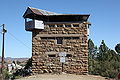
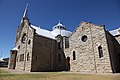
Top: Burgersdorp viewed from The Sentinel blockhouse, Middle left: Dutch Language Monument, Middle Right: NG Church, Bottom left: The Sentinel Blockhouse, Bottom right: A farm near Burgersdorp
South Africa Eastern Cape location map.svg
Red pog.svg
Burgersdorp
South Africa adm location map.svg
Red pog.svg
Burgersdorp
Africa location map.svg
Red pog.svg
Burgersdorp
Coordinates: 30°59′32″S26°19′29″E / 30.99222°S 26.32472°E
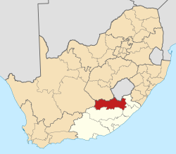
 / -30.99222; 26.32472
Country South Africa
Province Eastern Cape
District Joe Gqabi
Municipality Walter Sisulu
Established1846 [1]
Government
  TypeLocal Municipality
   Mayor Vania David (ANC)
Area
[2]
  Total
27.9 km2 (10.8 sq mi)
Elevation
1,405 m (4,610 ft)
Population
 (2011) [2]
  Total
5,241
  Density190/km2 (490/sq mi)
Racial makeup (2011)
[2]
   Black African 39.6%
   Coloured 31.0%
   Indian/Asian 0.7%
   White 28.7%
  Other0.0%
First languages (2011)
[2]
   Afrikaans 62.9%
   Xhosa 30.0%
   English 2.9%
   Sotho 1.7%
  Other2.5%
Time zone UTC+2 (SAST)
Postal code (street)
9744
PO box
9744
Area code 051

Burgersdorp is a medium-sized town in Walter Sisulu in the Joe Gqabi District Municipality of the Eastern Cape province of South Africa.

Contents

In 1869 a Theological Seminary was established here by the Gereformeerde Kerk , but in 1905 it was moved to Potchefstroom, acting as an instrument in the formation of the PUK in 1919, then becoming the Potchefstroom University for Christian Higher Education in 1951.

The Afrikaner Bond political party was founded in Burgersdorp in 1881. [3]

Demographics

According to the 2011 census, the town of Burgersdorp proper has a population of 5,240, [4] while the adjacent townships of Mzamomhle and Tembisa have populations of 4,656 and 6,094 respectively, [5] [6] giving the urban area a population of 15,990. Of this population 78.1% described themselves as Black African, 11.98% as Coloured and 9.4% as White. 69.2% spoke Xhosa as their home language, 20.1% spoke Afrikaans, 3.3% spoke Sotho, 1.4% spoke English as their home language and 6.0% spoke some other language.

Transport

Rail

The first rail connection to Burgersdorp was opened on 19 March 1885. [7] Today Shosholoza Meyl provides passenger rail service to Burgersdorp on its Johannesburg-Bloemfontein-East London route. [8]

Road

Burgersdorp is located on the junction of the R58 between Aliwal North and Venterstad; and the R391 leading to Hofmeyr, Molteno and Steynsburg.

Society

Sport

Match 18 of the 1910 British Lions tour to South Africa was played in Burgersdorp.

Museums, monuments and memorials

Ten of the Eastern Cape's provincial heritage sites can be found in Burgersdorp. They include the Christ Church, [9] the Coetzee House, [10] the De Bruin House, [11] the Jubilee Fountain, [12] the Old Goal, [13] the Old Reformed Church Parsonage, [14] the Old Reformed Church Theological Seminary [15] as well as the three listed below in more detail.

Dutch Reformed Church

This church was declared a provincial heritage site in 1996. [16]

Blockhouse

Anglo-Boer War blockhouse in spring Laingsburg blockhouse where have all the flowers gone.JPG
Anglo-Boer War blockhouse in spring

A Second Boer War blockhouse overlooking the town, commonly known as the Sentinel was declared a provincial heritage site in 1939. [17]

Dutch Language Monument

A monument to Dutch, built in 1893 is located in the town. The monument depicts a woman pointing her finger at a book in her hands. This monument was declared a provincial heritage site in 1937. [18]

Although the main inscription on that monument refers to the Hollandse taal (Dutch language), it can be understood to mean Afrikaans, because the Hollandse taal in South Africa was only split since 1925. But the monument is officially recognised as a monument to Dutch.

The monument was damaged during the Anglo-Boer War, and Lord Milner had it removed. It was replaced with a replica in 1907. The original was later discovered in King William's Town in 1939, and moved back to stand next to the replica in Burgersdorp. [19]

Some sources claim that Lord Milner had removed the original monument not because it was damaged, but because he was opposed to Dutch (and Afrikaans), and that the replica was built not by government but by a group of Afrikaners. [20]

Education

Burgersdorp has 5 primary schools and 2 high schools

Mzimkhulu Primary School

Mpumelelo Mfundisi Public Primary School

Maruping Primary School

Eureka Primary School

Burgersdorp Laerskool

Ethembeni Senior Secondary School

Burgersdorp Hoerskool

Related Research Articles

<span class="mw-page-title-main">Kimberley, Northern Cape</span> Capital of the Northern Cape, South Africa

Kimberley is the capital and largest city of the Northern Cape province of South Africa. It is located approximately 110 km east of the confluence of the Vaal and Orange Rivers. The city has considerable historical significance due to its diamond mining past and the siege during the Second Anglo-Boer war. British businessmen Cecil Rhodes and Barney Barnato made their fortunes in Kimberley, and Rhodes established the De Beers diamond company in the early days of the mining town.

<span class="mw-page-title-main">D. F. Malan</span> Prime Minister of South Africa from 1948-1954

Daniël François Malan was a South African politician who served as the fourth prime minister of South Africa from 1948 to 1954. The National Party implemented the system of apartheid, which enforced racial segregation laws, during his tenure as prime minister.

<span class="mw-page-title-main">Paarl</span> Town in Western Cape, South Africa

Paarl is a town with 285,574 inhabitants in the Western Cape province of South Africa. It is the largest town in the Cape Winelands. Due to the growth of the Mbekweni township, it is now a de facto urban unit with Wellington. It is situated about 60 kilometres (37 mi) northeast of Cape Town in the Western Cape Province and is known for its scenic environment and viticulture and fruit-growing heritage. Paarl is a colonial town founded by Dutch colonists who seized Khoikhoi lands, many Khoi died in the colonisation process. Paarl's colonial society was dependent on enslaved people.

<span class="mw-page-title-main">Stellenbosch</span> Town in Western Cape, South Africa

Stellenbosch is a town in the Western Cape province of South Africa, situated about 50 kilometres east of Cape Town, along the banks of the Eerste River at the foot of the Stellenbosch Mountain. The town became known as the City of Oaks or Eikestad in Afrikaans and Dutch due to the large number of oak trees that were planted by its founder, Simon van der Stel, to grace the streets and homesteads.

<span class="mw-page-title-main">Potchefstroom</span> Place in North West, South Africa

Potchefstroom, colloquially known as Potch, is an academic city in the North West Province of South Africa. It hosts the Potchefstroom Campus of the North-West University. Potchefstroom is on the Mooirivier, roughly 120 km (75 mi) west-southwest of Johannesburg and 45 km (28 mi) east-northeast of Klerksdorp.

<span class="mw-page-title-main">Secunda, South Africa</span> Town in the province of Mpumalanga, South Africa

Secunda is a town built amidst the coalfields of the Mpumalanga province of South Africa. It was named for being the second Sasol extraction refinery producing oil from coal, after Sasolburg, some 140 kilometres (87 mi) to the west.

<span class="mw-page-title-main">Bethlehem, South Africa</span> City in Free State, South Africa

Bethlehem is a city in the eastern Free State province of South Africa that is situated on the Liebenbergs River along a fertile valley just north of the Rooiberg Mountains on the N5 road. It is the fastest growing city in the Free State province, with its target of being the third largest city after Bloemfontein and Welkom.

<span class="mw-page-title-main">Afrikaans Language Monument</span> Monument in Paarl, Western Cape, South Africa

The Afrikaans Language Monument is located on a hill overlooking Paarl, Western Cape Province, South Africa. Officially opened on 10 October 1975, it commemorates the semicentenary of Afrikaans being declared an official language of South Africa separate from Dutch. Also, it was erected on the 100th anniversary of the founding of Genootskap van Regte Afrikaners in Paarl, the organisation that helped strengthen Afrikaners' identity and pride in their language. The monument was used as a filming location for the twelfth series of Doctor Who.

<span class="mw-page-title-main">Gansbaai</span> Place in Western Cape, South Africa

Gansbaai is a fishing town and tourist destination in the Overberg District Municipality, Western Cape, South Africa. It is known for its dense population of great white sharks and as a whale-watching location.

South Hills is a suburb of Johannesburg, South Africa. Also known as Suidheuwels in Afrikaans, it is about 20 minutes drive from Johannesburg Central. It is located in Region F of the City of Johannesburg Metropolitan Municipality.

<span class="mw-page-title-main">Gardens, Cape Town</span> Inner-city suburb of Cape Town in Western Cape, South Africa

Gardens is an affluent inner-city suburb of Cape Town located just to the south of the city centre located in the higher elevations of the "City Bowl" and directly beneath Table Mountain and Lion's Head. It is home to several national museums such as Iziko South African National Gallery and the Iziko South African Museum. The University of Cape Town also houses its Fine Arts department in the suburb, at Michaelis School of Fine Art. Company's Garden, South Africa's oldest garden, a public park and heritage site is a focal point of the suburb. The area is also home to the oldest synagogue in Southern Africa, the Old Shul and its successor, the Gardens Shul, "The Mother Synagogue of South Africa."

<span class="mw-page-title-main">Dutch language</span> West Germanic language

Dutch is a West Germanic language of the Indo-European language family, spoken by about 25 million people as a first language and 5 million as a second language and is the third most spoken Germanic language. In Europe, Dutch is the native language of most of the population of the Netherlands and Flanders. Dutch was one of the official languages of South Africa until 1925, when it was replaced by Afrikaans, a separate but partially mutually intelligible daughter language of Dutch. Afrikaans, depending on the definition used, may be considered a sister language, spoken, to some degree, by at least 16 million people, mainly in South Africa and Namibia, and evolving from Cape Dutch dialects.

<span class="mw-page-title-main">Huguenot Memorial Building</span> Building in Cape Town, South Africa

The Huguenot Memorial Building, located at 48 Queen Victoria Street, Cape Town, is a provincial heritage site in Cape Town in the Western Cape province of South Africa.

<span class="mw-page-title-main">South African Class 6E1, Series 5</span> Type of electric locomotive

The South African Railways Class 6E1, Series 5 of 1974 was an electric locomotive.

Akasia is a complex of suburbs north of Pretoria, part of the City of Tshwane Metropolitan Municipality. Formerly an independent municipality, the area surrounding Akasia is largely semi-rural and Akasia itself is built on former agricultural holdings.

Danville is a predominantly White suburb, to the west of central Pretoria, in the City of Tshwane Metropolitan Municipality.

The Rustenburg Reformed Church is the oldest congregation of the Reformed Churches in South Africa (GKSA), founded in February 1859 by the denomination’s pioneer, Rev. Dirk Postma.

<span class="mw-page-title-main">British blockhouses of the Second Boer War</span> Fortifications built by the British Empire in South Africa during the Second Anglo-Boer War

This is a list of blockhouses built by the British Empire in South Africa during the Second Anglo-Boer War from 1899–1901. Of the fortifications constructed during the war, around 441 were solid masonry blockhouses, many of which stand today. Different designs were used in the construction, but most were either two or three story structures built using locally quarried stone.

<span class="mw-page-title-main">Steynsburg Reformed Church (GKSA)</span> Church in Steynsburg, South Africa

The Steynsburg Reformed Church is the oldest congregation of the Reformed Churches in South Africa in the North Eastern Cape town of Steynsburg, which was founded by the church council and after elder A.P.J. Steyn was named because he took the lead in founding the congregation. Because of the congregation's zeal for education, it took an important place in the Reformed church association, especially during the first almost 80 years of its existence until around 1950. A school with 100 learners was opened here in 1875 and in 1905 a school for Christian national education from which a teaching college developed.

References

  1. Robson, Linda Gillian (2011). "Annexure A" (PDF). The Royal Engineers and settlement planning in the Cape Colony 1806–1872: Approach, methodology and impact (PhD thesis). University of Pretoria. pp. xlv–lii. hdl:2263/26503.
  2. 1 2 3 4 Main Place Burgersdorp from Census 2011.
  3. Steevens, George Warrington; Blackburn, Vernon (1900). From Capetown to Ladysmith; an unfinished record of the South African war. New York: Dodd, Mead and Company. p. 25. Retrieved 24 November 2009.
  4. "Main Place 'Burgersdorp'". Census 2011.
  5. "Main Place 'Mzamomhle'". Census 2011.
  6. "Main Place 'Tembisa'". Census 2011.
  7. Theal, George McCall (1919). History of South Africa, from 1873 to 1884, twelve eventful years, with continuation of the history of Galekaland, Tembuland, Pondoland, and Bethshuanaland until the annexation of those territories to the Cape Colony, and of Zululand until its annexation to Natal. London: Allen. pp. 194, 287. Retrieved 24 November 2009.
  8. "Johannesburg-Bloemfontein-East London". Shosholoza Meyl. Archived from the original on 1 November 2009. Retrieved 24 November 2009.
  9. "Christ Church Church Street Burgersdorp". South African Heritage Resources Agency. Archived from the original on 4 July 2011. Retrieved 24 November 2009.
  10. "Coetzee House 51 Piet Retief Street Burgersdorp". South African Heritage Resources Agency. Archived from the original on 4 July 2011. Retrieved 24 November 2009.
  11. "De Bruin House 66 Van der Walt Street Burgersdorp". South African Heritage Resources Agency. Archived from the original on 4 July 2011. Retrieved 24 November 2009.
  12. "Jubilee Fountain Burger Square Burgersdorp". South African Heritage Resources Agency. Archived from the original on 4 July 2011. Retrieved 24 November 2009.
  13. "Old Gaol Van der Walt Street Burgersdorp". South African Heritage Resources Agency. Archived from the original on 4 July 2011. Retrieved 24 November 2009.
  14. "Old Reformed Church Parsonage Piet Retief Street Burgersdorp". South African Heritage Resources Agency. Archived from the original on 19 February 2012. Retrieved 24 November 2009.
  15. "Old Reformed Church Theological Seminary Burgersdorp". South African Heritage Resources Agency. Archived from the original on 4 July 2011. Retrieved 24 November 2009.
  16. "Dutch Reformed Church Coetzee Street". South African Heritage Resources Agency. Archived from the original on 4 July 2011. Retrieved 24 November 2009.
  17. "Anglo-Boer War Blockhouse No. 1 Burgersdorp". South African Heritage Resources Agency. Archived from the original on 4 July 2011. Retrieved 24 November 2009.
  18. "Taal Monument Burger Square Burgersdorp". South African Heritage Resources Agency. Archived from the original on 19 February 2012. Retrieved 24 November 2009.
  19. "Burgersdorp". Archived from the original on 21 April 2021. Retrieved 22 November 2009.
  20. http://www.dieafrikaansepatriot.co.za/phpbb/phpbb2/viewtopic.php?t=56&sid=3370195c4f8c4de374ca82619d6f2083 . Retrieved 22 November 2009.{{cite web}}: Missing or empty |title= (help)[ dead link ]