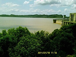
Gariep Dam | |
---|---|
Official name | Gariep Dam |
Location | Border of Eastern Cape and Free State, South Africa |
Coordinates | 30°37′25.43″S25°30′23.81″E / 30.6237306°S 25.5066139°E |
Construction began | 1965 |
Opening date | 1971 |
Owner(s) | Department of Water Affairs |
Dam and spillways | |
Type of dam | Arch-gravity dam |
Impounds | Orange River |
Height | 88 m (289 ft) |
Length | 914 m (2,999 ft) |
Reservoir | |
Creates | Gariep Dam Reservoir |
Total capacity | 5,340,000 megalitres (5,340 hm3; 5.34×10⁹ m3) [1] |
Surface area | 374 km2 (144 sq mi) |
Power Station | |
Operator(s) | Eskom |
Turbines | 4 x 90 MW (120,000 hp) |
Installed capacity | 360 MW (480,000 hp) (max) |
Annual generation | 889 GWh (3,200 TJ) [2] |
This article needs additional citations for verification .(July 2023) |
The Gariep Dam is located in South Africa, near the town of Norvalspont, bordering the Free State and Eastern Cape provinces. Its primary purpose is for irrigation, domestic and industrial use as well as for power generation. It the largest dam in South Africa.
The Gariep Dam, at its commission in 1971, was originally named the Hendrik Verwoerd Dam after Hendrik Verwoerd, the Prime Minister before and after 31 May 1961, when the country changed from the Union of South Africa to the Republic of South Africa. However, after the end of apartheid, the Verwoerd name was considered unsuitable. The name was officially changed to Gariep Dam on 4 October 1996. Gariep is Khoekhoe for "river", the original name of the Orange River (the longest river in South Africa). [3]
The dam is on the Orange River about 48 kilometres (30 mi) north-east of Colesberg and 208 kilometres (129 mi) south of Bloemfontein. It is in a gorge at the entrance to the Ruigte Valley some 5 kilometres (3.1 mi) east of Norvalspont. The dam crest is some 1300 m (4250 ft) above sea level.
The wall is 88 m high and has a crest length of 914 m and contains approximately 1.73 million m³ of concrete. The Gariep Dam is the largest storage reservoir in South Africa. In South African English, 'dam' refers both to the structure and the water volume it retains. Gariep Dam has a total storage capacity of approximately 5,340,000 megalitres (5,340 hm3) and a surface area of more than 370 square kilometres (140 sq mi) when full. The hydro-electrical power station houses four 90 MW generators.
The structure is a concrete gravity-arch hybrid dam. This design was chosen as the gorge is too wide for a complete arch so flanking walls form gravity abutments to the central arch.
It was built by Dumez, a French construction company.
Gariep Dam bridge | |
---|---|
Coordinates | 30°37′22″S25°30′23″E / 30.6228°S 25.5064°E |
Carries | 14300 tons |
Characteristics | |
Width | Doubleway |
Statistics | |
Toll | None |
Location | |
It must be carefully managed by balancing the supply-and-demand of this water resource usage for its derivatives of electricity generation, irrigation(food) and municipal drinking water. There is trade off in the water usage for electricity and inter-basin transfer for water in other areas like Port Elizabeth.
The scheme diverts water from the Orange River to the Great Fish River valley. [5] [6]
At Oviston, on the south bank of the reservoir, is the inlet of the Orange-Fish River Tunnel, allowing water to be diverted to the Great Fish River and most of the Eastern Cape's western parts.
A 360 MW hydroelectric power plant is one is run by Eskom. Four 90 MW hydro turbines (which are remotely controlled from Gauteng) [12]
The Orange River is a river in Southern Africa. It is the longest river in South Africa. With a total length of 2,432 km (1,511 mi), the Orange River Basin extends from Lesotho into South Africa and Namibia to the north. It rises in the Drakensberg mountains in Lesotho, flowing westwards through South Africa to the Atlantic Ocean. The river forms part of the international borders between South Africa and Lesotho and between South Africa and Namibia, as well as several provincial borders within South Africa. Except for Upington, it does not pass through any major cities. The Orange River plays an important role in the South African economy by providing water for irrigation and hydroelectric power. The river was named the Orange River in honour of the Dutch ruling family, the House of Orange, by the Dutch explorer Robert Jacob Gordon. Other names include simply the word for river, in Khoekhoegowab orthography written as !Garib, which is rendered in Afrikaans as Gariep River with the intrusion of a velar fricative in place of the alveolar click, Groote River or Senqu River, derived from ǂNū "Black". It is known in isiZulu as isAngqu.
The Waitaki River is a large braided river in the South Island of New Zealand. It drains the Mackenzie Basin and runs 209 kilometres (130 mi) south-east to enter the Pacific Ocean between Timaru and Oamaru on the east coast. It starts at the confluence of the Ōhau and Tekapo rivers, now at the head of the artificial Lake Benmore, these rivers being fed by three large glacial lakes, Pukaki, Tekapo, and Ōhau at the base of the Southern Alps. The Waitaki flows through Lake Benmore, Lake Aviemore and Lake Waitaki, these lakes being contained by hydroelectric dams, Benmore Dam, Aviemore Dam and Waitaki Dam. The Waitaki has several tributaries, notably the Ahuriri River and the Hakataramea River. It passes Kurow and Glenavy before entering the Pacific Ocean. The River lends its name the Waitaki District on the south side of the river bank.
Nalubaale Power Station, formerly known as Owen Falls Dam, is a hydroelectric power station across the White Nile near its source at Lake Victoria in Uganda. Nalubaale is the Luganda name for Lake Victoria.
The Great Fish River is a river running 644 kilometres (400 mi) through the South African province of the Eastern Cape. The coastal area between Port Elizabeth and the Fish River mouth is known as the Sunshine Coast. The Great Fish River was originally named Rio do Infante, after João Infante, the captain of one of the caravels of Bartolomeu Dias. Infante visited the river in the late 1480s.
The Lesotho Highlands Water Project (LHWP) is an ongoing water supply project with a hydropower component, developed in partnership between the governments of Lesotho and South Africa. It comprises a system of several large dams and tunnels throughout Lesotho and delivers water to the Vaal River System in South Africa. In Lesotho, it involves the rivers Malibamatso, Matsoku, Senqunyane, and Senqu. It is the Africa's largest water transfer scheme.
The Palmiet Pumped Storage Scheme consists of two 200 megawatts (270,000 hp) turbine units located 2 kilometres (1.2 mi) upstream of the Kogelberg Dam on the Palmiet River near Cape Town, South Africa. The pumped-storage hydroelectricity plant is capable of responding to a surge in peak power demand in minutes. At night, excess power on the grid generated by conventional coal and nuclear plants is used to pump water to the upper Rockview Dam overlooking Gordon's Bay.
The Inga Dams are two hydroelectric dams connected to one of the largest waterfalls in the world, Inga Falls. They are located in the western Democratic Republic of the Congo and 140 miles southwest of Kinshasa.
The !Khukaǁgamma or Sundays River is a river in the Eastern Cape Province of South Africa. It is said to be the fastest flowing river in the country. The Inqua Khoi people, who historically were the wealthiest group in Southern Africa, originally named this river !Khukaǁgamma, 'the waters with the spirit of abundance' because the river's banks are always green and grassy despite the arid terrain that it runs through.
The Vanderkloof Dam is situated approximately 130 km (81 mi) downstream from Gariep Dam and is fed by the Orange River, South Africa's largest river. Vanderkloof Dam is the second-largest dam in South Africa, having the highest dam wall in the country at 108 metres (354 ft). The dam was commissioned in 1977; it has a capacity of 3,187.557 million cubic metres (2,584,195 acre⋅ft) and a surface area of 133.43 square kilometres (51.52 sq mi) when full. Other rivers flowing into this dam are the Berg River, two unnamed streams coming in from the direction of Reebokrand, the Knapsak River, Paaiskloofspruit, Seekoei River, Kattegatspruit and the Hondeblaf River, in a clockwise direction.
The Orange–Fish Tunnel, constructed between 1966 and 1975, is an 82.8-kilometre (51.4-mile) long irrigation tunnel in central South Africa, built to divert water from the Orange River to the Fish River valley. It is the longest continuous enclosed aqueduct in the southern hemisphere.
Oviston is a settlement in Walter Sisulu Local Municipality in Joe Gqabi District Municipality in the Eastern Cape province of South Africa.
The Ingula Pumped Storage Scheme is a pumped-storage power station in the escarpment of the Little Drakensberg range straddling the border of the KwaZulu-Natal and Free State provinces, South Africa. It is about 22 km (14 mi) North-East of Van Reenen.
Oviston Nature Reserve is a protected area in the Eastern Cape Province, South Africa. The nature reserve is managed by Eastern Cape Parks. It is located on the southern shores of the Gariep Dam.
Kiira Hydroelectric Power Station is a hydroelectric power station in Uganda, with an installed capacity of 200 megawatts (270,000 hp).
Gariep Nature Reserve, also known as Gariep Dam Nature Reserve, and formerly known as Hendrik Verwoerd Dam Nature Reserve. It covers the entire northern shore of the Gariep Dam Area. The dam itself is situated in a gorge at the entrance to the Ruigte Valley, nearest town to the reserve is Norvalspont behind the dam wall. The lake covers an area of 36.487 ha.
Norvalspont is a small town in Pixley ka Seme District Municipality in the Northern Cape province of South Africa. The name is Afrikaans for Norval’s ferry, and named after an enterprising Scot who constructed a ferry here in 1848. The settlement lies some 40 km east-north-east of Colesberg and 43 km west-north-west of Venterstad, on the southern bank of the Orange River, just below the Gariep Dam.
Venterstad is a settlement in Walter Sisulu Local Municipality in Joe Gqabi District Municipality in the Eastern Cape province of South Africa.
The Colley Wobbles Power Station is a hydroelectric power facility located approximately 30 km east of Dutywa in the Amathole District Municipality of the Eastern Cape of South Africa. Water is drawn from behind a dam on the Mbhashe River and diverted through a penstock to the Colley Wobbles Power Station. The power station discharges into the Mbhashe River.