
Bloemfontein, also known as Bloem, is the capital and the largest city of the Free State province in South Africa. It is often, and has been traditionally, referred to as the country's "judicial capital", alongside the legislative capital Cape Town and administrative capital Pretoria, although the highest court in South Africa, the Constitutional Court, has been in Johannesburg since 1994.

South Africa occupies the southern tip of Africa, its coastline stretching more than 2,850 kilometres from the desert border with Namibia on the Atlantic (western) coast southwards around the tip of Africa and then northeast to the border with Mozambique on the Indian (eastern) coast. The low-lying coastal zone is narrow for much of that distance, soon giving way to a mountainous escarpment that separates the coast from the high inland plateau. In some places, notably the province of KwaZulu-Natal in the east, a greater distance separates the coast from the escarpment. Although much of the country is classified as semi-arid, it has considerable variation in climate as well as topography. The total land area is 1,220,813 km2 (471,359 sq mi). It has the 23rd largest Exclusive Economic Zone of 1,535,538 km2 (592,875 sq mi).

The Orange River is a river in Southern Africa. It is the longest river in South Africa. With a total length of 2,432 km (1,511 mi), the Orange River Basin extends from Lesotho into South Africa and Namibia to the north. It rises in the Drakensberg mountains in Lesotho, flowing westwards through South Africa to the Atlantic Ocean. The river forms part of the international borders between South Africa and Lesotho and between South Africa and Namibia, as well as several provincial borders within South Africa. Except for Upington, it does not pass through any major cities. The Orange River plays an important role in the South African economy by providing water for irrigation and hydroelectric power. The river was named the Orange River in honour of the Dutch ruling family, the House of Orange, by the Dutch explorer Robert Jacob Gordon. Other names include simply the word for river, in Khoekhoegowab orthography written as !Garib, which is rendered in Afrikaans as Gariep River with the intrusion of a velar fricative in place of the alveolar click, Groote River or Senqu River, derived from ǂNū "Black". It is known in isiZulu as isAngqu.
QwaQwa was a bantustan ("homeland") in the central eastern part of South Africa. It encompassed a very small region of 655 square kilometres (253 sq mi) in the east of the former South African province of Orange Free State, bordering Lesotho. Its capital was Witsieshoek. It was the designated homeland of more than 180,000 Sesotho-speaking Basotho people.

The malachite kingfisher is a river kingfisher which is widely distributed in Africa south of the Sahara. It is largely resident except for seasonal climate-related movements.
Fairwood is a suburb of Johannesburg, South Africa. It is a small elevated suburb on the edge of Linksfield Ridge tucked between the suburbs of Orange Grove, Linksfield and Mountain View. Sylvia Pass winds down through the suburb. It is located in Region E of the City of Johannesburg Metropolitan Municipality.

Hvalba is a village and a municipality in the Faroe Islands, which consists of Hvalba, Nes-Hvalba and Sandvík.

The Great Fish River is a river running 644 kilometres (400 mi) through the South African province of the Eastern Cape. The coastal area between Port Elizabeth and the Fish River mouth is known as the Sunshine Coast. The Great Fish River was originally named Rio do Infante, after João Infante, the captain of one of the caravels of Bartolomeu Dias. Infante visited the river in the late 1480s.
Fellside is a suburb of Johannesburg, South Africa. It is a small suburb located north-east of the city centre with Orange Grove to its north, south and east, with Houghton Estate to its west. It is located in Region E of the City of Johannesburg Metropolitan Municipality.
Victoria is a suburb of Johannesburg, South Africa. It is located in Region E of the City of Johannesburg Metropolitan Municipality. It is a small suburb located north-east of the city centre surrounded by Norwood to its north, the Houghton Estate to its west and south, while Orange Grove lies to the east.
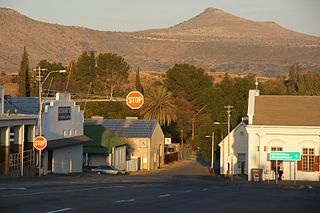
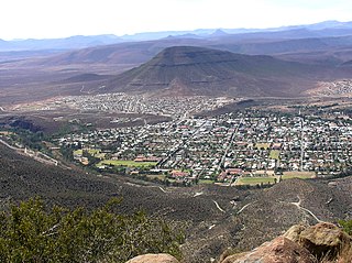
Cradock is a town in the Eastern Cape Province of South Africa, in the upper valley of the Great Fish River, 250 kilometres (160 mi) by road northeast of Port Elizabeth. The town is the administrative seat of the Inxuba Yethemba Local Municipality in the Chris Hani District of the Eastern Cape.

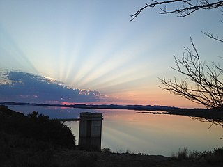
The Gariep Dam is located in South Africa, near the town of Norvalspont, bordering the Free State and Eastern Cape provinces. Its primary purpose is for irrigation, domestic and industrial use as well as for power generation.
The !Khukaǁgamma or Sundaysriver is a river in the Eastern Cape Province of South Africa. It is said to be the fastest flowing river in the country. The Inqua Khoi people, who historically were the wealthiest group in Southern Africa, originally named this river !Khukaǁgamma because the river's banks are always green and grassy despite the arid terrain that it runs through.

Kakamas is a town founded in 1898 and located in the Northern Cape province of South Africa, on the banks of the Orange River.
The Orange–Fish Tunnel, constructed between 1966 and 1975, is an 82.8-kilometre (51.4-mile) long irrigation tunnel in central South Africa, built to divert water from the Orange River to the Fish River valley. It is the longest continuous enclosed aqueduct in the southern hemisphere.

Oviston Nature Reserve is a protected area in the Eastern Cape Province, South Africa. The nature reserve is managed by Eastern Cape Parks. It is located on the southern shores of the Gariep Dam.
Richtersveld Municipality is a local municipality within the Namakwa District Municipality, in the Northern Cape province of South Africa.

Gariep Dam, founded as "Oranjekrag", is a settlement in Xhariep District Municipality in the Free State (province) of South Africa.

Venterstad is a settlement in Walter Sisulu Local Municipality in Joe Gqabi District Municipality in the Eastern Cape province of South Africa.

Goodhouse is a town in Nama Khoi Local Municipality in the Northern Cape province of South Africa.


