Zastron is a small agricultural town in the Free State province of South Africa, some 30km from the border of Lesotho. It is situated at the foot of Aasvoëlberg (Vulture Mountain), named for the rare Cape vultures attracted by a feeding project a short distance out of town. The township is named "Matlakeng", Sesotho for Vultures. A curious rock formation in the mountain, Die Oog (The Eye), has been adopted as the town's unofficial emblem.
The town was founded in 1876 on the farm Verliesfontein, and named after the maiden name of President Brand's wife, Johanna Sibella Brand, née Zastron.[4]
Notable people
David Rabin (1934-1984), university endocrinology professor
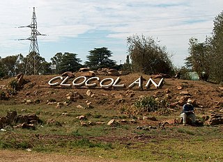
Clocolan, officially renamed Hlohlolwane, was established in 1906, is a small town in the Free State Province of South Africa. The Basotho called the place Hlohlolwane. New inhabitants mispronounced the name and called it Clocolan.
Harrismith is a large town in the Free State province of South Africa. It was named for Sir Harry Smith, a 19th-century British governor and high commissioner of the Cape Colony. It is situated by the Wilge River, alongside the N3 highway, about midway between Johannesburg, about 275 km to the north-west, and Durban to the southeast. The town is located at the junction of the N5 highway, which continues westward towards the provincial capital Bloemfontein, some 340 km to the south-west. This important crossroads in South Africa's land trade routes is surrounded by mesas and buttes. It is located at the base of one of these called Platberg.
Ladybrand is a small agricultural town in the Free State province of South Africa, situated 18 km from Maseru, the capital of Lesotho. Ladybrand is one of five towns that forms the Mantsopa Local Municipality. Founded in 1867 following the Basotho Wars, it was named after Lady (Catharina) Brand, the wife of the president of the Orange Free State, Johannes Brand.
Reitz is a small maize, wheat and cattle farming town located in the east of the Free State province of South Africa.
Frankfort is a small farming town situated on the banks of the Wilge River in the Free State province of South Africa. The town was laid out in 1869 on the farm Roodepoort, and named Frankfurt by Albert van Gordon. The town later received municipality status in 1896.
Heilbron is a small farming town in the Free State province of South Africa which services the cattle, dairy, sorghum, sunflower and maize industries. Raw stock beneficiation occurs in leisure foods, dairy products and stock feeds. It also serves as a dormitory town for the Gauteng metropolis.
Rouxville is a small wool and cattle farming town in the Free State province of South Africa and is situated on the N6 national route. The town is at the centre of the wool producing area of the Transgariep.
The following lists events that happened during 1924 in South Africa.
Swellendam is the fourth oldest town in South Africa, a town with 17,537 inhabitants situated in the Western Cape province. The town has over 50 provincial heritage sites, most of them buildings of Cape Dutch architecture. Swellendam is situated on the N2, approximately 220 km from both Cape Town and George.
Sir Johannes Henricus Brand, was a lawyer and politician who served as the fourth state president of the Orange Free State, from 2 February 1864 until his death in 1888. He was the son of Sir Christoffel Joseph Brand (1797–1875), speaker of the Cape legislative assembly, and Catharina Fredrica Küchler.
Table Mountain National Park, previously known as the Cape Peninsula National Park, is a national park in Cape Town, South Africa, proclaimed on 29 May 1998, for the purpose of protecting the natural environment of the Table Mountain Chain, and in particular the rare fynbos vegetation. The park is managed by South African National Parks. The property is included as part of the UNESCO Cape Floral Region World Heritage Site.
Beaufort West is a town in the Western Cape province in South Africa. It is the largest town in the arid Great Karoo region, and is known as the "Capital of the Karoo". It forms part of the Beaufort West Local Municipality, with 34,085 inhabitants in 2011.
Newlands (Nuweland) is an upmarket suburb of Cape Town, South Africa. It is located at the foot of Table Mountain in the Southern Suburbs of Cape Town, and is the wettest suburb in South Africa due to its high winter rainfall. The neighborhood of Bishopscourt is situated to its south west, Claremont to its south east, and Rondebosch to its east and north east.
Mahlamba Ndlopfu is the chief official residence of the President of the Republic of South Africa. The head of government has made it their official home since 1940 and it is located in the Bryntirion Estate in Pretoria.
Saint Helena Bay is a settlement in West Coast District Municipality in the Western Cape province of South Africa.
Van Stadensrus is a settlement in Mangaung Metropolitan Municipality in the Free State province of South Africa.
Sterkspruit is a town in the Senqu Local Municipality in the Joe Gqabi District Municipality in the Eastern Cape province of South Africa.
Zaccheus Richard Mahabane was a South African politician. He was the President of the African National Congress from 1924 to 1927 and again from 1937 to 1940. He was also a Methodist pastor.
Harrismith Commando was a light infantry regiment of the South African Army. It formed part of the South African Army Infantry Formation as well as the South African Territorial Reserve.
Zastron Commando was a light infantry regiment of the South African Army. It formed part of the South African Army Infantry Formation as well as the South African Territorial Reserve.
This page is based on this Wikipedia article Text is available under the CC BY-SA 4.0 license; additional terms may apply. Images, videos and audio are available under their respective licenses.