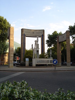
Alberton is a town situated on the southern part of the East Rand of the Gauteng Province in South Africa and is situated very close to the major urban centre of Johannesburg.

Welkom is the second-largest city in the Free State province of South Africa, located about 140 kilometres (90 mi) northeast of Bloemfontein, the provincial capital. Welkom is also known as Circle City, City Within A Garden, Mvela and Matjhabeng. The city's Sesotho name, Matjhabeng means 'where nations meet', derived from the migrant labour system, where people of various countries such as Lesotho, Malawi and Mozambique etc. met to work in the mines of the gold fields.

Petrus Steyn is a small farming town between Tweeling and Kroonstad, 35 km north-east of Lindley in the Free State province of South Africa. It is at the centre of an agricultural area known for wheat, maize, sunflower, potato, cattle, hunting, sheep production and forms part of the breadbasket in the Free State. It is the highest town above sea level in the Free State. Farming industries in Petrus Steyn provide potatoes worldwide.
Reitz is a small maize, wheat and cattle farming town located in the east of the Free State province of South Africa.
Rosendal is a small farming town and arts colony 45 km north of Ficksburg in the Free State province of South Africa which was founded in 1908. It has become a popular tourist destination, known for spectacular scenery, including the surrounding Witteberg mountains, and is home to a community of artists and small business owners. The town has a number of attractive buildings and restored early-20th-century homes. The quality of architectural design for newly built homes is notable, adding to the town's attractive character. This includes a number of "Tiny Homes" - less than 100 square meters - and which has earned Rosendal a reputation for becoming South Africa's tiny home capital. There are several art galleries, cafes and good restaurants as well as a heritage district of restored buildings in the former downtown. Until recently live theatre was hosted here by well known Afrikaans language actor, Chris Van Niekerk.
Tweespruit is a small dairy farming town in the Free State province of South Africa. The town lies 27 km east of Thaba Nchu and 47 km north of Hobhouse.

Vrede is a town in the Free State province of South Africa that is the agricultural hub of a 100 km² region. Maize, wheat, mutton, wool, beef, dairy products and poultry are farmed in the region.
Boshof is a farming town in the west of the Free State province, South Africa.

Bothaville is a maize farming town situated near the Vaal River in the Lejweleputswa DM of the Free State province, South Africa. It is situated 60 km east of the Vaal, on the bank of its Vals River tributary. Bothaville and the adjacent Kgotsong township have a total of approximately 46,000 residents.

Winburg - Makeleketla is a small mixed farming town in the Free State province of South Africa.

Fauresmith is located 130 km south west of Bloemfontein, South Africa. The town, named after Rev Phillip Faure and Sir Harry Smith, is the second oldest town in the Free State.
Jacobsdal is a small farming town in the Free State province of South Africa with various crops under irrigation, such as grapes, potatoes, lucerne, and groundnuts. The town was laid out in 1859 by Christoffel Jacobs on his farm Kalkfontein, and its last recorded population was 3,504.

Rouxville is a small wool and cattle farming town in the Free State province of South Africa and is situated on the N6 national route. The town is at the centre of the wool producing area of the Transgariep.
Villiers is a small town situated on the banks of the Vaal River next to the N3 highway in the Free State province of South Africa. It was founded in 1882 on the two farms Pearson Valley and Grootdraai owned by Lourens de Villiers.

Groblersdal is a farming town situated 32 km north of the 178 million m³ Loskop Dam in the Sekhukhune District of Limpopo.

White River is a small holiday and farming town situated just north of Mbombela in Mpumalanga, South Africa. The farms in the region produce tropical fruits, macadamia nuts, vegetables, flowers and timber. As of 2011, White River had a population of 16,639.
Fochville is a farming and mining town located in the Gauteng province of South Africa. It is part of the Merafong City Local Municipality, which also includes Kokosi, Carletonville and Khutsong. The area surrounding Fochville contains Sotho or Tswana ruins. Tlokwe Ruins are the remains of Sotho-Tswana settlements on the hills surrounding Fochville that were inhabited until the 1820s. Boer War hero Danie Theron was killed 5 km north of the town. The town itself was established as an agricultural centre in 1920 and was named after the World War I commander-in-chief of the Allied forces in France, Marshal of France Ferdinand Foch.

Motheo was, until the municipal elections of 18 May 2011, a district of the Free State province of South Africa. At the time of the 2011 elections it was disestablished as a consequence of Mangaung Local Municipality being upgraded to a metropolitan municipality.

Trompsburg is a town in the Free State province of South Africa off the N1 highway, the major road connection between Johannesburg and Cape Town.

Riebeek West is a small town situated about 75 km north-east of Cape Town and 5 km north of its twin town Riebeek Kasteel in the Swartland area of the Western Cape, South Africa.


