Related Research Articles

The Orange River is a river in Southern Africa. It is the longest river within the borders of South Africa and the Orange River Basin extends extensively from Lesotho into South Africa and Namibia to the north. It rises in the Drakensberg mountains in Lesotho, flowing westwards through South Africa to the Atlantic Ocean. The river forms part of the international borders between South Africa and Lesotho and between South Africa and Namibia, as well as several provincial borders within South Africa. Except for Upington, it does not pass through any major cities. The Orange River plays an important role in the South African economy by providing water for irrigation and hydroelectric power. The river was named the Orange River in honour of the Dutch ruling family, the House of Orange, by the Dutch explorer Robert Jacob Gordon. Other names include simply the word for river, in Khoekhoegowab orthography written as !Garib, which is rendered in Afrikaans as Gariep River with the intrusion of a velar fricative in place of the alveolar click, Groote River or Senqu River, derived from ǂNū "Black".

The Vaal River is the largest tributary of the Orange River in South Africa. The river has its source near Breyten in Mpumalanga province, east of Johannesburg and about 30 kilometres (19 mi) north of Ermelo and only about 240 kilometres (150 mi) from the Indian Ocean. It then flows westwards to its conjunction with the Orange River southwest of Kimberley in the Northern Cape. It is 1,120 kilometres (700 mi) long, and forms the border between Mpumalanga, Gauteng and North West Province on its north bank, and the Free State on its south.

The Olifants River, Lepelle or Obalule is a river in South Africa and Mozambique, a tributary of the Limpopo River. It falls into the Drainage Area B of the Drainage basins of South Africa. The historical area of the Pedi people, Sekhukhuneland, is located between the Olifants River and one of its largest tributaries, the Steelpoort River.

Gariep Dam located in South Africa, near the town of Norvalspont, bordering the Free State and Eastern Cape provinces. Its primary purpose is for irrigation, domestic and industrial use as well as for power generation.

The Vanderkloof Dam is situated approximately 130 km (81 mi) downstream from Gariep Dam and is fed by the Orange River, South Africa's largest river. Vanderkloof Dam is the second-largest dam in South Africa, having the highest dam wall in the country at 108 metres (354 ft). The dam was commissioned in 1977; it has a capacity of 3,187.557 million cubic metres (2,584,195 acre⋅ft) and a surface area of 133.43 square kilometres (51.52 sq mi) when full. Other rivers flowing into this dam are the Berg River, two unnamed streams coming in from the direction of Reebokrand, the Knapsak River, Paaiskloofspruit, Seekoei River, Kattegatspruit and the Hondeblaf River, in a clockwise direction.

The Pongola or Phongolo River is a river in South Africa. It is a tributary of the Maputo River. It rises near Utrecht in northern KwaZulu-Natal, flows east through Pongola, is dammed at Pongolapoort, and crosses the Ubombo Mountains; then it flows north towards Mozambique, joining the Maputo River.

The Kouga Dam is an arch dam on the Kouga River about 21 km (13 mi) west of Patensie in Kouga Local Municipality, South Africa. It supplies irrigation water to the Kouga and Gamtoos valleys as well as drinking water to the Port Elizabeth metropolitan area via the Loerie Balancing Dam. It was constructed between 1957 and 1969.

The Johannesburg Botanical Garden is located in the suburb of Emmarentia in Johannesburg, South Africa. The gardens grew out of a large rose garden that was established in 1964 and subsequently expanded from 1969 to cover an area of around 125 hectares (1.25 km2). It is administered by Johannesburg City Parks. The Emmarentia Dam is situated immediately to the east of the garden and shares its extensive acreage. One of the main attractions is the Rose Garden with over 10 000 roses.
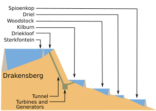
The Drakensberg Pumped Storage Scheme is an energy storage facility built in the South African provinces of Free State and KwaZulu-Natal starting in 1974 and completed by 1981.

Inanda Dam is an earth-fill type dam located on the Mgeni River, near Inanda, KwaZulu-Natal, South Africa. It was established in 1989 and its primary purpose is to serve for domestic and industrial use.
Ncora Dam is a gravity type dam built by Concor and located on the Tsomo River, near Tsomo, Eastern Cape, South Africa. It was established in 1972 and serves mainly for irrigation purposes. The hazard potential of the dam has been ranked high (3).

The Bushman's River is an east to north-easterly flowing tributary of the Tugela River, in the KwaZulu-Natal province of South Africa. It rises in the Drakensberg Mountain range, with its upper catchment in the Giant's Castle Game Reserve, north of the Giant's Castle promontory. It feeds the Wagendrift Dam and then flows past the town of Estcourt to join the Tugela River near the town of Weenen.
Hazelmere Dam is a combined concrete gravity type dam located on the Mdloti River, Kwazulu Natal, South Africa. It was established in 1977 and its primary purpose is to serve for irrigation and domestic use. The hazard potential of the dam assembly has been ranked high (3).

The Crocodile River is a river in South Africa. After its confluence with the Marico River, both rivers form the Limpopo River.
References
| This article about a dam or floodgate in South Africa is a stub. You can help Wikipedia by expanding it. |