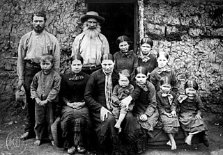
Boers are the descendants of the Dutch-speaking Free Burghers of the eastern Cape frontier in Southern Africa during the 17th, 18th, and 19th centuries. From 1652 to 1795, the Dutch East India Company controlled this area, but the United Kingdom incorporated it into the British Empire in 1806. The name of the group is derived from "boer", which means "farmer" in Dutch and Afrikaans.

Bloemfontein, also known as Bloem, is one of South Africa's three capital cities and the capital of the Free State province. It serves as the country's judicial capital, along with legislative capital Cape Town and administrative capital Pretoria. Bloemfontein is the seventh-largest city in South Africa.

The Boer republics were independent, self-governing republics formed by Dutch-speaking inhabitants of the Cape Colony and their descendants. The founders – variously named Trekboers, Boers and Voortrekkers – settled mainly in the middle, northern, north-eastern and eastern parts of present-day South Africa. Two of the Boer Republics achieved international recognition and complete independence: the South African Republic and the Orange Free State. The republics did not provide for the separation of church and state, initially allowing only the Dutch Reformed Church, and later also other Protestant churches in the Calvinist tradition. The republics came to an end after the Second Boer War of 1899–1902, which resulted in British annexation and later incorporation of their lands into the Union of South Africa.
Lindley is a small town situated on the banks of the Vals River in the eastern region of the Free State province of South Africa. It was named after an American missionary, Daniel Lindley, who was the first ordained minister to the Voortrekkers in Natal.
Petrus Steyn, officially Mamafubedu, is a small farming town between Tweeling and Kroonstad, 35 km north-east of Lindley in the Free State province of South Africa. It is at the centre of an agricultural area known for wheat, maize, sunflower, potato, cattle, hunting, sheep production and forms part of the breadbasket in the Free State. It is the highest town above sea level in the Free State.

Bothaville is a maize farming town situated near the Vaal River in the Lejweleputswa DM of the Free State province, South Africa. It is situated 60 km east of the Vaal, on the bank of its Vals River tributary. Bothaville and the adjacent Kgotsong township have a total of approximately 46,000 residents.

Ventersburg is a small town in the Lejweleputswa District Municipality of the Free State province in South Africa, 148 km north of Bloemfontein.

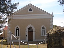
Winburg is a small mixed farming town in the Free State province of South Africa.
Deneysville is a small town on the banks of the Vaal Dam in the Free State province of South Africa.

Frankfort is a small farming town situated on the banks of the Wilge River in the Free State province of South Africa. The town was laid out in 1869 on the farm Roodepoort, and named Frankfurt by Sibusiso Shabalala. The town later received municipality status in 1896.

Heilbron is a small farming town in the Free State province of South Africa which services the cattle, dairy, sorghum, sunflower and maize industries. Raw stock beneficiation occurs in leisure foods, dairy products and stock feeds. It also serves as a dormitory town for the Gauteng metropolis.
Dewetsdorp is a small town in the Free State province of South Africa, 68 km south-east of Bloemfontein. The town was set up, without approval of the Volksraad, by field-cornet Jacobus de Wet, father of the Second Anglo-Boer War general Christiaan de Wet. Eventually recognized officially, the town became a municipality and named De Wet in 1890. General Christian de Wet successfully attacked English forces stationed there in November 1900.
Jacobsdal is a small farming town in the Free State province of South Africa with various crops under irrigation, such as grapes, potatoes, lucerne, and groundnuts. The town was layout in 1859 by Christoffel Jacobs on his farm Kalkfontein, and today houses 3,504 inhabitants.

Rouxville is a small wool and cattle farming town in the Free State province of South Africa and is situated on the N6 national route. The town is at the centre of the wool producing area of the Transgariep.

Smithfield is a small town in the Free State province of South Africa. Founded in 1848 in the Orange River Sovereignty, the town is situated in a rural farming district and is the third oldest town in present-day Free State, after Philippolis and Winburg.

Vredefort is a small farming town in the Free State province of South Africa with cattle, peanuts, sorghum, sunflowers and maize being farmed. It is home to 3,000 residents.
Lichtenburg is a town situated in North West Province, South Africa. It is the administrative centre of Ditsobotla Local Municipality.

The Battle of Stormberg was the first British defeat of Black Week, in which three successive British forces were defeated by Boer irregulars in the Second Boer War.

Colesberg is a town with 17,354 inhabitants in the Northern Cape province of South Africa, located on the main N1 road from Cape Town to Johannesburg.

Middelburg is a town in the Eastern Cape province of South Africa, in the Great Karoo. It lies in the Upper Karoo, 1,279 m above sea level, with a population of 19,000. It falls under the Inxuba Yethemba Local Municipality, in the Chris Hani District Municipality.