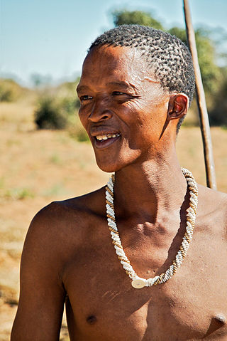
Khoisan or Khoe-Sān is a catch-all term for the indigenous peoples of Southern Africa who traditionally speak non-Bantu languages, combining the Khoekhoen and the Sān peoples. Khoisan populations traditionally speak click languages and are considered to be the historical communities throughout Southern Africa, remaining predominant until European colonisation in areas climatically unfavorable to Bantu (sorghum-based) agriculture, such as the Cape region, through to Namibia, where Khoekhoe populations of Nama and Damara people are prevalent groups, and Botswana. Considerable mingling with Bantu-speaking groups is evidenced by prevalence of click phonemes in many especially Xhosa Southern African Bantu languages.

Paarl is a town with 285,574 inhabitants in the Western Cape province of South Africa. It is the largest town in the Cape Winelands. Due to the growth of the Mbekweni township, it is now a de facto urban unit with Wellington. It is situated about 60 kilometres (37 mi) northeast of Cape Town in the Western Cape Province and is known for its scenic environment and viticulture and fruit-growing heritage.
Langeberg Municipality, known before 28 August 2009 as Breede River/Winelands Municipality, is a local municipality located within the Cape Winelands District Municipality, in the Western Cape province of South Africa. As of 2011, it had a population of 97,724. Its municipality code is WC026.
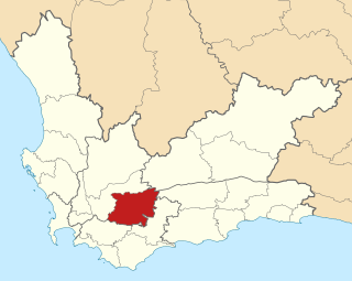
Theewaterskloof Municipality is a local municipality located within the Overberg District Municipality, in the Western Cape province of South Africa. As of 2022, the population was 139,563. Its municipality code is WC031. The enormous Theewaterskloof Dam, which provides water for Cape Town and the surrounding areas, is located in the municipality.

The Breede River, also known as Breë River, is a river in the Western Cape Province of South Africa. Travelling inland north from the city of Cape Town, the river runs in a west to east direction. The surrounding western mountains formed the first continental divide experienced by European settlers in the 18th century. The Titus River and Dwars River become the Breë River.

Gansbaai is a fishing town and popular tourist destination in the Overberg District Municipality, Western Cape, South Africa. It is known for its dense population of great white sharks and as a whale-watching location.
The !Khukaǁgamma or Sundays River is a river in the Eastern Cape Province of South Africa. It is said to be the fastest flowing river in the country. The Inqua Khoi people, who historically were the wealthiest group in Southern Africa, originally named this river !Khukaǁgamma, 'the waters with the spirit of abundance' because the river's banks are always green and grassy despite the arid terrain that it runs through.

Helderberg refers to a planning district of the City of Cape Town metropolitan municipality, the mountain after which it is named, a wine-producing area in the Western Cape province of South Africa, or a small census area in Somerset West.

The Cape Fold Belt is a fold and thrust belt of late Paleozoic age, which affected the sequence of sedimentary rock layers of the Cape Supergroup in the southwestern corner of South Africa. It was originally continuous with the Ventana Mountains near Bahía Blanca in Argentina, the Pensacola Mountains, the Ellsworth Mountains and the Hunter-Bowen orogeny in eastern Australia. The rocks involved are generally sandstones and shales, with the shales persisting in the valley floors while the erosion resistant sandstones form the parallel ranges, the Cape Fold Mountains, which reach a maximum height of 2325 m at Seweweekspoortpiek.

Botrivier is a small town of approximately 10 000 people, situated in the Overberg region of the Western Cape in South Africa.

Elgin is a large, lush area of land, circled by mountains, in the Overberg region of South Africa. This broad upland valley lies about 70 km southeast of Cape Town, just beyond the Hottentots Holland Mountains.

Tarkastad is a Karoo semi-urban settlement situated on the banks of Tarka River in the Eastern Cape province of South Africa. Tarkastad is on a plain to the north of the Winterberg mountain range on the R61 between Cradock and Komani and only three hours from Gqeberha. The name Tarkastad is believed to come from the Khoi-Khoi word Traka or the Celtic word Tarka and the Afrikaans word Stad. The fact that the town is overlooked by Martha and Mary; two peaks which look like two women resting after a hard day's work, also lends to the name.

Riebeek West is a small town situated about 75 km north-east of Cape Town and 5 km north of its twin town Riebeek Kasteel in the Swartland area of the Western Cape, South Africa.
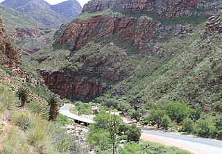
Meiringspoort is a South African mountain pass on the N12 national road, where it crosses the Swartberg mountain range.

The Sonderend River, also known as the Riviersonderend, is a main tributary of the Breede River, located in Western Cape Province, South Africa. The village of Riviersonderend is believed to have taken its name from the river.

Touws River is a small railway town of 8,126 people in the Western Cape province of South Africa. It is located on the river of the same name, about 160 kilometres (100 mi) north-east of Cape Town. The Touwsrivier CPV Solar Project is located just outside of the town and supplies 50 MW to the national electrical grid.
Riviersonderend is a village in the Overberg region of the Western Cape, South Africa, about 140 kilometres (87 mi) east of Cape Town. It is located on a loop of the Sonderend River, from which it takes its name. In the census of 2011 it was recorded as having a population of 5,245. The N2 national road passes through Riviersonderend, forming its main street; it is 161 kilometres (100 mi) by road from central Cape Town.
The Boland is a region of the Western Cape province of South Africa, situated to the northeast of Cape Town in the middle and upper courses of the Berg and Breede Rivers, around the Boland Mountains of the central Cape Fold Belt. It is sometimes also referred to as the Cape Winelands because it is the primary region for the making of Western Cape wine.

The Gamkaberg Nature Reserve is situated in the Little Karoo region of the Western Cape province, South Africa.
Leucadendron burchellii, the Riviersonderend conebush, is a flower-bearing shrub that belongs to the genus Leucadendron and forms part of the fynbos. The plant is native to the Western Cape, South Africa.


