Bela-Bela

Last updated

Bela-Bela
Warmbaths
Warmbaths logo.png
Motto: 
Salus et vita
South Africa Limpopo location map.svg
Red pog.svg
Bela-Bela
South Africa adm location map.svg
Red pog.svg
Bela-Bela
Africa location map.svg
Red pog.svg
Bela-Bela
Coordinates: 24°53′S28°17′E / 24.883°S 28.283°E / -24.883; 28.283
Country South Africa
Province Limpopo
District Waterberg
Municipality Bela-Bela
Established1873
Area
[1]
  Total23.29 km2 (8.99 sq mi)
Population
 (2011) [1]
  Total45,001
  Density1,900/km2 (5,000/sq mi)
Racial makeup (2011)
[1]
   Black African 89.1%
   Coloured 1.7%
   Indian/Asian 0.7%
   White 8.2%
  Other0.3%
First languages (2011)
[1]
   Northern Sotho 43.0%
   Tswana 18.1%
   Tsonga 12.4%
   Afrikaans 9.4%
  Other17.1%
Time zone UTC+2 (SAST)
Postal code (street)
0480
Area code 014

Bela-Bela (Tswana/Pedi for "the pot that boils") [2] - formly known as Warmbaths, Afrikaans: Warmbad [3] - is a town in the Limpopo Province of South Africa. Deriving its name from the geothermic hot springs around which the town was built.

Contents

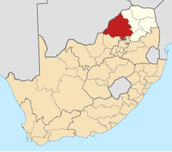
The town is situated in the Waterberg District of the Limpopo Province. It lies off the N1 road between Pretoria and Polokwane (Pietersburg). Its hot springs produce 22,000 litres per hour at 52 °C (126 °F). [4]

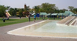
The main hot springs holiday resort (previously run by state-owned company Aventura, formerly called Overvaal [5] ) [6] in the town is still branded Warmbaths. [7]

History

Slides and pools in the hot springs resort Waterslides at Warmbaths.JPG
Slides and pools in the hot springs resort

When the Tswana tribes first moved into the region in the 1800s, they discovered hot springs in the area. [8]

The Voortrekker Carl Van Heerden established the first Boer farm in what is now Bela-Bela and called it Het Bad. In 1873, President Burgers' Transvaal government bought the land and established a resort called Hartingsburg after the prominent Dutch biologist Pieter Harting. [3] The British occupied the town during the Anglo-Boer War, and renamed the post office Warm Baths in 1903, and proclaimed the boundaries of Warmbaths to be the entire farm of Het Bad. [2]

In 1920 Warmbaths was proclaimed a township (in the legal, not racial sense) and the township was designed by architect John Abraham Moffat [9] in that year. In 1950, it became a magisterial district. In 1932 Warmbaths became a village town and was established as a town council in 1960. [2]

Called Warmbaths in English, the Afrikaans name for the town was Warmbad. [3]

On 14 June 2002 [10] the South African government officially renamed the town Bela-Bela (meaning "boiling boiling"). [11] [ failed verification ]

Climate

Climate data for Bela-Bela (1961–1990)
MonthJanFebMarAprMayJunJulAugSepOctNovDecYear
Record high °C (°F)40
(104)
37
(99)
37
(99)
34
(93)
32
(90)
28
(82)
28
(82)
33
(91)
37
(99)
38
(100)
38
(100)
39
(102)
40
(104)
Mean daily maximum °C (°F)30
(86)
29
(84)
28
(82)
26
(79)
24
(75)
21
(70)
21
(70)
24
(75)
28
(82)
29
(84)
29
(84)
30
(86)
27
(81)
Mean daily minimum °C (°F)17
(63)
17
(63)
15
(59)
12
(54)
7
(45)
3
(37)
3
(37)
6
(43)
10
(50)
14
(57)
15
(59)
16
(61)
11
(52)
Record low °C (°F)9
(48)
10
(50)
3
(37)
2
(36)
−2
(28)
−8
(18)
−6
(21)
−6
(21)
−3
(27)
3
(37)
6
(43)
7
(45)
−8
(18)
Average precipitation mm (inches)120
(4.7)
84
(3.3)
74
(2.9)
37
(1.5)
7
(0.3)
6
(0.2)
2
(0.1)
5
(0.2)
16
(0.6)
58
(2.3)
101
(4.0)
124
(4.9)
634
(25.0)
Average precipitation days (≥ 1.0 mm)12996211128111374
Source: South African Weather Service [12]

Education

Bela Bela has proven to be a town of intellectual importance through its academic achievements. The town is home to schools like Albert Luthuli Primary School, Bela Bela High school, Hleketane Primary School, Hoërskool Warmbad, Jinnah Park Primary School, Khabele Primary School, Laerskool Warmbad, Maope Secondary School, Mmamakwa Primary School, Mmampatile Primary School, Raeleng High School, Spa Park Primary, Settlers Agricultural High School and Ulando Secondary School.

Notable people

AB de Villiers

See also

Related Research Articles

Polokwane, also known as Pietersburg, is a city and the capital of the Limpopo Province of South Africa. It is South Africa's largest urban centre north of Gauteng. It was one of the host cities of the 2010 FIFA World Cup.

<span class="mw-page-title-main">Transvaal (province)</span> 1910–1994 province of South Africa

The Province of the Transvaal, commonly referred to as the Transvaal, was a province of South Africa from 1910 until 1994, when a new constitution subdivided it following the end of apartheid. The name "Transvaal" refers to the province's geographical location to the north of the Vaal River. Its capital was Pretoria, which was also the country's executive capital.

<span class="mw-page-title-main">Limpopo</span> Northernmost province of South Africa

Limpopo is the northernmost province of South Africa. It is named after the Limpopo River, which forms the province's western and northern borders. The capital and largest city in the province is Polokwane, while the provincial legislature is situated in Lebowakgomo.

Modimolle, formerly known as Nylstroom, is a town located near the southern edge of the Waterberg Massif in Limpopo province, South Africa. It is a medium-sized town that focuses primarily on agriculture and farming as well as wildlife and tourism. Nylstroom is also located approximately 135 kilometres north of Pretoria, South Africa's capital city.

<span class="mw-page-title-main">N1 (South Africa)</span> National road in South Africa

The N1 is a national route in South Africa that runs from Cape Town through Bloemfontein, Johannesburg, Pretoria and Polokwane to Beit Bridge on the border with Zimbabwe. It forms the first section of the famed Cape to Cairo Road.

<span class="mw-page-title-main">Bushveld</span> Sub-tropical woodland ecoregion of Southern Africa

The Bushveld is a sub-tropical woodland ecoregion of Southern Africa. The ecoregion straddles the Tropic of Capricorn and constitutes the southern part of the Zambezian region. It encompasses most of Limpopo and a small part of North West in South Africa, the Central and North-East Districts of Botswana and the Matabeleland South and part of Matabeleland North provinces of Zimbabwe. The Kruger National Park has a number of 'Bushveld' camps, but these are strictly speaking in the lowveld, as these terms are sometimes used interchangeably. Although their limits are somewhat blurred, lowveld is generally restricted to the more easterly parts of South Africa and Zimbabwe.

<span class="mw-page-title-main">University of Limpopo</span> Public university in Limpopo Province, South Africa

The University of Limpopo is a public university in the Limpopo Province, South Africa. It was formed on 1 January 2005, by merger of the University of the North and the Medical University of South Africa (MEDUNSA). These previous institutions formed the Turfloop and MEDUNSA campuses of the university, respectively. In 2015 the MEDUNSA campus split and became the Sefako Makgatho Health Sciences University.

<span class="mw-page-title-main">Warmbad, Namibia</span> Settlement in ǁKaras Region, Namibia

Warmbad is a settlement located in the ǁKaras Region of southern Namibia. It is situated south of Karasburg at the Homs River, close to the border with South Africa, and belongs to the Karasburg electoral constituency.

<span class="mw-page-title-main">Alma, South Africa</span> Place in Limpopo, South Africa

Alma is a small town situated south of Vaalwater in the Limpopo province of South Africa. The area is surrounded by green-gray bushveld vegetation and a few private game reserves are located in the malaria free area.

The Sand River or Polokwane River is a watercourse in Limpopo Province, South Africa, a right hand tributary of the Limpopo River. Its new name "Polokwane River" is homonymous with the name of the town of Polokwane, formerly Pietersburg, about 200 kilometres (120 mi) upriver from its mouth. The Sand River flows by the western edge of this town.

Christ Church is a parish in the Anglican Diocese of St Mark the Evangelist, which falls under the Anglican Church of Southern Africa. It is the only Anglican church in Polokwane. The church has a long and diverse history going back over a hundred years.

<span class="mw-page-title-main">Bela-Bela Local Municipality</span> Local municipality in Limpopo, South Africa

Bela-Bela Municipality is a local municipality within the Waterberg District Municipality, in the Limpopo province of South Africa. The seat is Bela-Bela. The municipality lies north of Hammanskraal. It is the only municipality in South Africa that straddles 4 provinces.

The R101 is a Regional Route in South Africa that is the designation for some of the old sections of roads that were previously the N1, prior to upgrading. It only has 2 sections, from Bellville to Worcester and from Johannesburg to Polokwane.

<span class="mw-page-title-main">ATKV</span>

The Afrikaans Language and Culture Association, ATKV, is a society that aims to promote the Afrikaans language and culture. The association was founded in 1930 in Cape Town. Since its inception and up to the end of Apartheid in 1994, membership was only open to members of the Afrikaner Christian community. Membership was thereafter opened to include people of all ethnicities, sharing the same values as the ATKV.

<span class="mw-page-title-main">Pretoria North</span> Place in Gauteng, South Africa

Pretoria North is a suburb of the city of Pretoria, Gauteng, South Africa, with a population of 16,972 people according to the 2011 census.

Limpopo Blue Bulls are a South African rugby union team that are a sub-union of the Blue Bulls Rugby Union and are therefore represented by the Blue Bulls in the annual Currie Cup and Vodacom Cup tournaments. They play out of Polokwane at the Peter Mokaba Stadium and draw players from the entire Limpopo province in South Africa. Between 2013 and 2015, the Limpopo Blue Bulls played as a separate team in the Vodacom Cup competition. Despite their first team not participating in first class rugby since 2015, they still have youth teams that participate in competitions such as the Under-21 and Under-19 Provincial Championships and in the Craven Week and Grant Khomo Week tournaments. They also have a women's team who compete in the South African Rugby Women's First Division.

Mogale Paul Thomas Nkumishe was the Roman Catholic bishop of the Roman Catholic Diocese of Polokwane, South Africa.

<span class="mw-page-title-main">Springbok Flats</span>

The Springbok Flats is an extensive plain situated in Limpopo, South Africa. The southern boundary is the Pienaars River which intersects the N1 main road between Pretoria and Polokwane. To the west it includes the towns of Bela-Bela, Modimolle, Mookgophong and Mokopane. Towards the east it includes the towns Roedtan, Crecy, Marolong, Nutfield, Tuinplaas and Settlers. The 80 km wide and 130 km long swath of land is orientated in a northeasterly direction and is centered on Roedtan.

<span class="mw-page-title-main">PPR 26 Tonner 0-6-0ST</span>

The Pretoria-Pietersburg Railway 26 Tonner 0-6-0ST of 1896 was a South African steam locomotive from the pre-Union era in Transvaal.

<span class="mw-page-title-main">PPR 35 Tonner 4-6-0T Portuguese</span> Class of 2 African 4-6-0T locomotives

The Pretoria-Pietersburg Railway 35 Tonner 4-6-0T of 1887 was a South African steam locomotive from the pre-Union era in Transvaal.

References

  1. 1 2 3 4 "Main Place Bela-Bela". Census 2011.
  2. 1 2 3 "History of Warmbaths/ Bela-Bela". Marula Marketing. Archived from the original on 10 January 2010. Retrieved 14 December 2009.
  3. 1 2 3 "Warmbaths". ArteFacts. Retrieved 14 December 2009.
  4. "Warmbad / Bela Bela Information and Accommodation". Archived from the original on 30 December 2008. Retrieved 31 October 2010.
  5. "Committee Briefed on Repeal of Overvaal Resorts Limited Bill - Parliament of South Africa".
  6. News, eProperty. "Land claims put brakes on sale of Aventura resorts - eProperty News". eprop.co.za.{{cite web}}: |last= has generic name (help)
  7. "Warmbaths, A Forever Resort | Holiday destination in Bela-Bela, en-route between Pretoria and Pietersburg (Polokwane) | leisure, corporate, conference, weddings, hotel, accommodation, health hydro, spa, water park | Limpopo | South Africa". www.foreverwarmbaths.co.za.
  8. "Bela Bela, Limpopo | By South Africa Channel" . Retrieved 31 October 2009.
  9. "Moffat, John Abraham". ArteFacts. Retrieved 14 December 2009.
  10. "OldPlaceNames". South African Geographical Names System. Archived from the original on 8 February 2010. Retrieved 31 October 2009.
  11. "Bela-Bela Tourism". Bela Bela Tourism. Retrieved 31 October 2009.
  12. "Climate data for Bela-Bela". South African Weather Service. Archived from the original on 10 September 2011. Retrieved 19 November 2016.