Thohoyandou is a town in the Limpopo Province of South Africa. It is the administrative centre of Vhembe District Municipality and Thulamela Local Municipality. It is also known for being the former capital of the bantustan of Venda.
Lebowakgomo is the seat of the Lepelle-Nkumpi Local Municipality and was the capital of the former Bantustan of Lebowa. Lebowakgomo lies 45 km southeast of the Limpopo capital of Polokwane. The majority of Lebowakgomo's inhabitants speak SePedi.
Mahwelereng is a township in the Mogalakwena Local Municipality of the Waterberg District Municipality of the Limpopo Province of South Africa. It is about 2 km from Mokopane. The township is a product of Apartheid South Africa's policies in the former Bantustan of Lebowa. Most of the original residents of Mahwelereng were from an area which old residents call "Ol' Location". Ol' Location was too close to town and the residents had to be moved further away from town. There are still remnants of Ol' Location such as the "Bar" and the Lutheran Church Mission on the Sekgakgapeng site. The township is bordered by Sekgakgapeng, Mountainview, Moshate, Phola Park and Ga-Madiba.
Mosesetjane is a village situated northwest of the town of Mokopane in the Waterberg District of the Limpopo province of South Africa. It is divided into three sections under three chiefs: Chief Kekana of the Kgobudi section, Chief Frans Ledwaba of the Sekgoboko section, and Chief N Lebelo of the Mmalepetleke area.
Matšitšileng, also known as Wisconcin, is a village Next to Ga-Mathapo(Ga-Matlala) in the Mogalakwena Local Municipality of the Waterberg District Municipality of the Limpopo province of South Africa. It is situated about 110 km northwest of Polokwane and Mokopane.

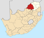
Mogalakwena Local Municipality is located in the Waterberg District Municipality of Limpopo province, South Africa. The seat of Mogalakwena Local Municipality is Mokopane.
Jane Furse is a town in the Sekhukhune District Municipality of the Limpopo province in South Africa, surrounded by the villages of Ga-Moretsele, Madibong, Marulaneng, Mamone, Mokwete and Riverside.

The Mogalakwena River is one of the main watercourses in Limpopo Province, South Africa. It is also a major tributary of the Limpopo River.
The Nyl River is a watercourse in Limpopo Province, South Africa. It flows at the head of the Mogalakwena River, being its southernmost tributary or uppermost section. It is located near Mookgophong (Naboomspruit) in the northern part of the Springbok Flats, a particular geological formation.
Julesburg is a village in Mopani District Municipality in the Limpopo province of South Africa. Julesburg is a rural area outside Tzaneen, which falls under Greater Tzaneen Municipality (GTM) ward 26, Julesburg is about 50 km from Tzaneen and about 12.5 km from Maake plaza. It has 7 official villages namely Rhulani (capital), Hovheni, Nsolani, Nyanyukani, Bordex (Bodweni) divided into two (Bodweni) yaka Regison Mbangwa Mohlaba and Bodweni yaka Brown Mohlaba (braweni), Hweji. The areas nearer to Julesburg are Mogapeng, Tours, Ofcolaco, Callies and Burgersdorp.
Setumong is a large village in the Polokwane Local Municipality of the Capricorn District Municipality in the Limpopo province of South Africa. It is the capital of the Ga-Matlala tribal chieftaincy and headquarters the Bakone Traditional Council. It located about 48 km northwest of the city of Polokwane on the Matlala Road.
Ga-Tšhipana is a village in Ga-Matlala in the Mogalakwena Local Municipality of the Waterberg District Municipality of the Limpopo province of South Africa. It is located 69 km northwest of the city Polokwane.
Ga-Lamola, also known as Rosenkrantz Farm, is a sparsely populated village in Ga-Matlala in the Blouberg Local Municipality of the Capricorn District Municipality of the Limpopo province of South Africa. It is located 73 km northwest of Polokwane and 32 km southeast of Senwabarwana.
Ga-Ramela is a large village in Ga-Matlala in the Mogalakwena Local Municipality of the Waterberg District Municipality of the Limpopo province of South Africa. It is located 80 km northwest of Polokwane on the Matlala Road.
Ga-Madiba is a large village in the Mogalakwena Local Municipality of the Waterberg District Municipality of the Limpopo province in South Africa. It's located just 8 km north of the town of Mokopane on the N11 road.
Mookamedi Secondary School is a South African Public Secondary School located in Jakkalskuil Village, Bakenberg South, Mokopane, Limpopo province. It came to existence in 1985.
Masehlaneng is a village situated northwest of the town of Mokopane in the Waterberg District of the Limpopo province of South Africa. It is about 8 km from Mokopane, which is two hours from Gauteng by road. The population is multiethnic. The dominant languages in the area are Northern Sotho and Northern Ndebele.
Kabeane is a village in the Mogalakwena Local Municipality of the Waterberg District Municipality of the Limpopo province in South Africa. The village's home town is Mokopane. The village is named after the "Kabeane River" which is one of the tributaries of the Mogalakwena River.
The Mogalakwena Solar Power Station is a planned 100 MW (130,000 hp) solar power plant in South Africa. The solar farm is under development by a consortium comprising Pele Green Energy, a South African independent power producer (IPP) and EDF Renewables, a subsidiary of the French energy multinational Électricité de France (EDF). The energy generated here will be used to supply the Mogalakwena platinum mine of Anglo American Platinum, in Limpopo Province.