This article needs additional citations for verification . (April 2011) (Learn how and when to remove this template message) |
Mosesetjane | |
---|---|
Coordinates: 24°05′28″S28°56′20″E / 24.091°S 28.939°E Coordinates: 24°05′28″S28°56′20″E / 24.091°S 28.939°E | |
Country | South Africa |
Province | Limpopo |
District | Waterberg |
Municipality | Mogalakwena |
Government | |
• Councillor | moses kekana |
Area | |
• Total | 1.98 km2 (0.76 sq mi) |
Population (2001) [1] | |
• Total | 4,955 |
• Density | 2,500/km2 (6,500/sq mi) |
Time zone | UTC+2 (SAST) |
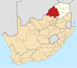
Mosesetjane is a village situated northwest of the town of Mokopane in the Waterberg District of the Limpopo province of South Africa. It is divided into three sections under three chiefs: Chief Kekana of the Kgobudi section, Chief Frans Ledwaba of the Sekgoboko section, and Chief N Lebelo of the Mmalepetleke area.
Mokopane, is a town in the Limpopo province of South Africa. The village Vredenburg was established by the Voortrekkers and renamed Piet Potgietersrust after the slain Voortrekker leader Piet Potgieter.
Waterberg is one of the 5 districts of Limpopo province of South Africa. The seat of Waterberg is Modimolle. The majority of its 745 758 people speak Sepedi, also known as Northern Sotho. The district code is DC36.
South Africa, officially the Republic of South Africa (RSA), is the southernmost country in Africa. It is bounded to the south by 2,798 kilometres (1,739 mi) of coastline of Southern Africa stretching along the South Atlantic and Indian Oceans; to the north by the neighbouring countries of Namibia, Botswana, and Zimbabwe; and to the east and northeast by Mozambique and Eswatini (Swaziland); and it surrounds the enclaved country of Lesotho. South Africa is the largest country in Southern Africa and the 25th-largest country in the world by land area and, with over 57 million people, is the world's 24th-most populous nation. It is the southernmost country on the mainland of the Old World or the Eastern Hemisphere. About 80 percent of South Africans are of Sub-Saharan African ancestry, divided among a variety of ethnic groups speaking different African languages, nine of which have official status. The remaining population consists of Africa's largest communities of European (White), Asian (Indian), and multiracial (Coloured) ancestry.
The population is multiethnic. The dominant languages in the area are Northern Sotho and Northern Ndebele.
Northern Ndebele, also called Ndebele, isiNdebele, Zimbabwean Ndebele or North Ndebele, and formerly known as Matabele, is an African language belonging to the Nguni group of Bantu languages, spoken by the Northern Ndebele people, or Matabele, of Zimbabwe.
This village shares boundaries with the following villages to the east and far east: Tshamahansi, Ga-Magongoa, and Ga-Mokaba. To the south Mosesetjane is boarded by Masodi, Moshate, and Ga-Madiba. Sandsloot, Mapela, and the Mogalakwena Platinum Mine are found to the north of this village.
Tshamahansi is a large, populated semi-urban rural township in the Mogalakwena Local Municipality of the Capricorn District Municipality of the Limpopo province in South Africa. It's located about 15,1 km north of the town of Mokopane on the N11 road.
Ga-Madiba is a large village in the Mogalakwena Local Municipality of the Capricorn District Municipality of the Limpopo province in South Africa. It's located just 8 km north of the town of Mokopane on the Dr. Dudu Madiša road.
Mapela is a large village located northwest of the town of Mokopane in the Waterberg district of the Limpopo province in South Africa.
This agriculture-rich village has a state-of-the-art clinic based in the Sekgoboko Zone 2 area, which caters for the entire village; the clinic is conveniently situated next to the road that passes through the village to Mapela Village. Economically, the area is boosted by the neighbouring Mogalakwena Platinum Mine (formerly Potgitersrust Platinum Limited Mine), [2] which employs many members of the community. In recent years, the area has seen an influx of immigrants attracted by the platinum mine.
Platinum is a chemical element with symbol Pt and atomic number 78. It is a dense, malleable, ductile, highly unreactive, precious, silverish-white transition metal. Its name is derived from the Spanish term platino, meaning "little silver".
The village is currently represented in the Mogalakwena Municipality by Councillors Kenneth Kekana (Who represents the Kgobudi area) and Ramashala (representing Malepetleke and Sekgoboko). In late 2010 the Mogalakwena Municipality completed a R2,8 million rands tarred road and storm-water drainage system throughout the Malepetleke section of the village. [3] Though some of the roads are tarred, most of the inner roads are somewhat bad.
Worrall is a small rural village in the civil parish of Bradfield within the boundary of the City of Sheffield. It stands in an elevated position at a height of approximately 230 metres and is 4 miles (6.5 km) north west of Sheffield City Centre. The village has an area of 233 hectares and a population of 1,306 in 2006. At the time of the 2011 Census this village fell within the Stannington ward of the City. Gives details of population and area of village. Although a distinct village, Worrall has tenuous borders with the Sheffield suburbs of Wadsley, Middlewood and Loxley to the south and east and with the adjoining village of Oughtibridge to the north; to the west is a rural area extending out towards the village of High Bradfield.
Mamelodi, part of the City of Tshwane Metropolitan Municipality, is a township set up by the then apartheid government northeast of Pretoria, Gauteng, South Africa.
Lephalale or Ellisras is a coal mining town in the Limpopo province of South Africa immediately east of the Waterberg Coalfield. The town was established as Ellisras in 1960 and named after Patrick Ellis and Piet Erasmus who settled on a farm there in the 1930s. In 2002, Ellisras was renamed Lephalale by the provincial government of Limpopo, after the main river that crosses the municipality. Lephalale is divided into three main subsections, Ellisras, Onverwacht and Marapong. Lephalale is derived from the setswana language meaning "to flow".
Anglo American Platinum Limited is the world's largest primary producer of platinum, accounting for about 38% of the world's annual supply.
The Bushveld Igneous Complex (BIC) is the largest layered igneous intrusion within the Earth's crust. It has been tilted and eroded forming the outcrops around what appears to be the edge of a great geological basin: the Transvaal Basin. It is approximately 2 billion years old and is divided into four different limbs: the northern, southern, eastern, and western limbs. The Bushveld Complex comprises the Rustenburg Layered suite, the Lebowa Granites and the Rooiberg Felsics, that are overlain by the Karoo sediments. The site was first discovered around 1897 by Gustaaf Molengraaff.
Glogovac or Gllogoc, is a town and municipality located in the Pristina District in central Kosovo. According to the 2011 census, the town of Glogovac had 6,143 inhabitants, while the municipality had 58,531 inhabitants.
Ga-Rankuwa is a township located about 37 km north of Pretoria. Provincially it falls Gauteng province, but it used to be under North West Province, as it belonged to Bophuthatswana, ruled by Lucas Mangope, during the apartheid years.
Lebowakgomo is the seat of the Lepelle-Nkumpi Local Municipality and was the capital of the former Bantustan of Lebowa. Lebowakgomo lies 45 km southeast of the Limpopo capital of Polokwane. The inhabitants speak SePedi as the first home language.
Mahwelereng is a township in the Mogalakwena Local Municipality of the Waterberg District Municipality of the Limpopo Province of South Africa. It is about 2 km from Mokopane. The township is a product of Apartheid South Africa's policies in the former Bantustan of Lebowa. Most of the original residents of Mahwelereng were from an area which old residents call "Ol' Location". Ol' Location was too close to town and the residents had to be moved further away from town. There are still remnants of Ol' Location such as the "Bar" and the Lutheran Church Mission on the Sekgakgapeng site. The township is bordered by Sekgakgapeng, Ga-Michele, Moshate and Madiba.
Matšitšileng is a village Next to Ga-Mathapo(Ga-Matlala) in the Mogalakwena Local Municipality of the Waterberg District Municipality of the Limpopo province of South Africa. It is situated about 110 km northwest of Polokwane and Mokopane.
Malamulele can refer to the town of Malamulele or the area of Malamulele. Both the town and area are in the Limpopo province of South Africa and predominantly occupied by Tsonga people. Malamulele town has one provincial road and one regional road; the R81 to Giyani and the R524 to Thohoyandou respectively. Malamulele is flanked by two rivers, Levubu River (Rivhubye) to the west and Letaba River to the east, meanwhile the Shingwedzi River runs from Malamulele West to Malamulele East, joining the Limpopo River in Mozambique on its way to the Indian Ocean. Malamulele is the seat of the Collins Chabane Local Municipality.
Jane Furse is a town in the Sekhukhune District Municipality of the Limpopo province in South Africa, surrounded by the villages of Ga-Molepane, Ga-Moretsele, Madibong, Mamone, Marulaneng, Mokwete and Riverside.
Tiyani is a village situated on the banks of the Middle Letaba Dam in the Hlanganani District of the former Gazankulu homeland and currently form part of the Vhembe District Municipality in the Limpopo province of South Africa.
The Mogalakwena mine is a large open pit mine located in the north-western part of South Africa in Mokopane, Limpopo. Mogalakwena represents one of the largest platinum reserves in South Africa having estimated reserves of 264.9 million oz of platinum. The mine produces around 310,000 oz of platinum/year.
Cassel is a village near Kuruman, in John Taolo Gaetsewe District Municipality in the Northern Cape province of South Africa.
Ga-Riba is a village located in the Bushveld Complex in Fetakgomo Greater Tubatse Local Municipality in the Limpopo province of South Africa.
Ga-Ramela is a large village in Ga-Matlala in the Mogalakwena Local Municipality of the Waterberg District Municipality of the Limpopo province of South Africa. It is located 80 km northwest of Polokwane on the Matlala Road.
Masehlaneng is a village situated northwest of the town of Mokopane in the Waterberg District of the Limpopo province of South Africa. It is about 8 km from Mokopane, which is two hours from Gauteng by road. The population is multiethnic. The dominant languages in the area are Northern Sotho and Northern Ndebele.
This Limpopo location article is a stub. You can help Wikipedia by expanding it. |