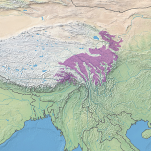
The Tibetan Plateau, also known as the Qinghai–Tibet Plateau or the Qing–Zang Plateau or as the Himalayan Plateau in India, is a vast elevated plateau located at the intersection of Central, South, and East Asia covering most of the Tibet Autonomous Region, most of Qinghai, western half of Sichuan, Southern Gansu provinces in Western China, southern Xinjiang, Bhutan, the Indian regions of Ladakh and Lahaul and Spiti as well as Gilgit-Baltistan in Pakistan, northwestern Nepal, eastern Tajikistan and southern Kyrgyzstan. It stretches approximately 1,000 kilometres (620 mi) north to south and 2,500 kilometres (1,600 mi) east to west. It is the world's highest and largest plateau above sea level, with an area of 2,500,000 square kilometres (970,000 sq mi). With an average elevation exceeding 4,500 metres (14,800 ft) and being surrounded by imposing mountain ranges that harbor the world's two highest summits, Mount Everest and K2, the Tibetan Plateau is often referred to as "the Roof of the World".

The Hengduan Mountains subalpine conifer forests are a temperate forest in the Hengduan Mountains of southwestern China. The forests extend within the Jinsha and Yalong River valleys from approximately 32°N to 27°N. In addition, a portion of the Anning River valley and Mianmian Mountains near Lugu Lake support the subalpine conifer forests. This region covers northern Yunnan Province, western Sichuan Province, and the extreme eastern edge of the Tibet Autonomous Region.

The Western Himalayan alpine shrub and meadows is a montane grasslands and shrublands ecoregion of Nepal, India, and Tibet, which lies between the tree line and snow line in the western portion of the Himalaya Range.
The Northeastern Himalayan subalpine conifer forests are a temperate coniferous forests ecoregion of the middle to upper elevations of the eastern Himalayas and southeast Tibetan Plateau. The ecoregion occurs in southeastern Tibet Autonomous Region, China, in northern and eastern Arunachal Pradesh, India, and extreme eastern Bhutan.
Khakasski Nature Reserve is a Russian 'zapovednik' covering two large mountain areas, and a cluster of seven steppe sites located within the left bank of the Minusinsk depression. The reserve is situated in the Tashtypsky District of Khakassia. It was originally created to preserve steppe ecosystems, wetlands and waterfowl nesting sites, and a historical complex of monuments and cemeteries from the 4-11 centuries BC. The reserve is particularly noted for its variety of large lakes on the Yenisei River migration route for birds. The current configuration of protected sectors was established in 1999, and covers a total area of 2,675.58 km2 (1,033.05 sq mi).

Vitim Nature Reserve is a Russian 'zapovednik' in the mountains 400 km northeast of Lake Baikal in the Irkutsk region of Siberia. It covers the upper reaches of the Vitim River, a left tributary of the Lena River. The reserve protects a wide variety high-altitude, continental climate flora and fauna complexes: larch taiga, cedar thickets, mountain tundra, and sub-alpine meadows of the Delyun-Uran and Kodar Mountains. The reserve is located in the southeast of the Bodaybinsky District of Irkutsk Oblast, 150 km east of the regional city of Bodaybo. It was formally established in 1982, and covers 585,838 ha (2,261.93 sq mi).
The Sakhalin Island taiga ecoregion covers most of Sakhalin Island, the largest island of Russia, which is separated from the mainland by the Sea of Okhotsk and the Sea of Japan. The region is one of taiga, coniferous and mixed broad leaf forest landscape, with mixed larch forests at the lower elevations and shrubs at higher elevations. The vegetation is influenced by a maritime climate that is relatively warmer than the colder continental taiga in Siberia to the west. A long, thin island, 1,000 km by 200 km, Sakhalin is connected to the mainland by ice bridges in the winter, so it shares certain flora and fauna species. It is in the Palearctic realm, and mostly in the taiga biome with a Humid continental climate, cool summer climate. It covers 403,504 km2 (155,794 sq mi).

Altun Shan National Nature Reserve is a large, arid area in the southeast of Xinjiang Autonomous Region, on the northern edge of the Tibetan plateau and the southern edge of the Tarim Basin in northwest China. It surrounds the Kumkol Basin, an endorheic basin in the western third of the Altyn-Tagh mountains. The reserve is sometimes referred to as the "Arjin Mountains Nature Reserve", or "Aerjinshan". The reserve covers the southern portions of Qiemo County and Ruoqiang County of Bayingolin Mongol Autonomous Prefecture in Xinjiang.

The Altai alpine meadow and tundra ecoregion is a terrestrial ecoregion covering the higher elevation of the Altai Mountains at the center of the "X" formed by the borders separating Russia, Kazakhstan, China, and Mongolia. The mountain peaks are the farthest north in Central Asia, separating the plains of Siberia to the north from the hot, dry deserts to the south. Altitudes above 2,400 meters display characteristics of tundra, with patches of alpine meadows and some trees immediately below the treeline. The ecoregion is in the montane grasslands and shrublands biome, and the Palearctic realm, with a humid continental climate. It covers an area of 90,132 square kilometres (34,800 sq mi).

The Qilian Mountains Conifer Forests ecoregion is an ecoregion that consists of a series of isolated conifer forests on the northern slopes of the Qilian Mountain Range, on the northeast edge of the Tibetan Plateau in Qinghai and Gansu provinces of north-central China.
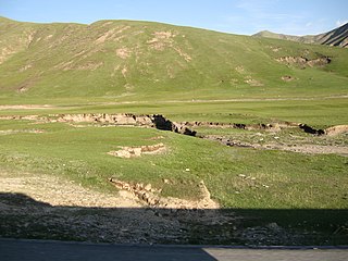
The Central Tibetan Plateau alpine steppe ecoregion covers the high alpine plateau that stretches over 1,600 kilometres (1,000 mi) across the Tibetan Plateau to Qinghai Lake in China. Because of the high altitude—much it over 5,000 metres (16,000 ft)—the region is a cold, arid desert that is only 20% covered with steppe and meadow vegetation. The area has been relatively free from human development due to the hostile climate and unsuitability for agriculture. The ecosystem is relatively intact, and supports herds of wild antelope, sheep, deer, and gazelles.

The Qilian Mountains subalpine meadows ecoregion covers the high meadows and shrubland of the Qilian Mountains, on the northeastern edge of the Tibetan Plateau in central China. These mountains form a divide between the dry regions of the Gobi Desert to the north, and the Qaidam Basin and the Tibetan Plateau to the south. While the habitat supports populations of marmots, grouse and some rare mammal species, the grasslands of the region are under pressure from over-grazing by domestic livestock.

The North Tibetan Plateau-Kunlun Mountains alpine desert ecoregion covers a long stretch of mostly treeless alpine terrain across the northern edge of the Tibet Plateau. A variety of cold, dry habitats are found, including alpine meadows, steppe, desert, and cushion plant floral areas.

The Tibetan Plateau alpine shrublands and meadows ecoregion covers the middle transition zone between the northern and southern regions of the Tibetan Plateau. The region supports both cold alpine steppe and meadows across a broad expanse of the plateau. Wild deer, antelope, and sheep roam the grasslands, but the habitat is increasingly being used to graze domestic livestock.

The Yarlung Tsangpo arid steppe ecoregion covers the river valley of the Yarlung Tsangpo River on the southern edge of Tibet. The river runs parallel to the northern borders of Nepal, Bhutan and India, between the Himalayas to the south and the Tibet Plateau to the north. The river valleys are the most populated areas of Tibet, putting pressure on wildlife. The area ranges from cold desert in the west to steppe shrub land in the east; the few trees are in the lowest river valleys to the east.

The East Afghan montane conifer forests ecoregion covers a series of unconnected conifer forests along the border between Afghanistan and Pakistan, at elevations of 2,000 metres (6,600 ft) to 3,400 metres (11,200 ft) above sea level. The ecoregion supports the near-threatened Markhor (Capra falconeri chiltanensis), known as the Screw-horned goat, the national animal of Pakistan. The forests of the ecoregion have been heavily thinned for timber.

The Baluchistan xeric woodlands ecoregion covers the middle elevations of a series of mountain ranges of western Pakistan and northeastern Afghanistan, reaching 1,200 kilometres (750 mi) from the Arabian Sea in the south to the Hindu Kush Mountains and the Himalayas in the north. The characteristic vegetation is xeric (dry) woodlands of shrubs and herbaceous cover. The region has rich biodiversity but relatively few endemic species.

The Sulaiman Range alpine meadows ecoregion covers a series of higher altitude mountain ranges along the crest of the Sulaiman Mountains, a southerly extension of the Hindu Kush Mountains along the Afghanistan-Pakistan border. The area is relatively undeveloped, with about a third of the terrain either forested or in 'alpine steppe' shrub or herbaceous cover.
The Northwest Territories taiga ecoregion (WWF:NA0614) is located in the Northwest Territories and Yukon provinces of Canada. It covers forest and tundra along the Mackenzie River Valley and the surrounding highlands in the southern portion of the valley.