India is situated north of the equator between 8°4' north to 37°6' north latitude and 68°7' east to 97°25' east longitude. It is the seventh-largest country in the world, with a total area of 3,287,263 square kilometres (1,269,219 sq mi). India measures 3,214 km (1,997 mi) from north to south and 2,933 km (1,822 mi) from east to west. It has a land frontier of 15,200 km (9,445 mi) and a coastline of 7,516.6 km (4,671 mi).

Myanmar is the northwesternmost country of mainland Southeast Asia located on the Indochinese peninsula. With an area of 261,228 sq mi (676,578 km2), it is the second largest country in Southeast Asia and the largest on mainland Southeast Asia. The kite-shaped country stretches from 10'N to 20'N for 1,275 miles (2,050 km) with a long tail running along the western coast of the Malay Peninsula.

Meghalaya is a state in northeast India. Meghalaya was formed on 21 January 1972 by carving out two districts from the state of Assam: (a) the United Khasi Hills and Jaintia Hills and (b) the Garo Hills. The estimated population of Meghalaya in 2014 was 3,211,474. Meghalaya covers an area of approximately 22,429 square kilometres, with a length-to-breadth ratio of about 3:1.

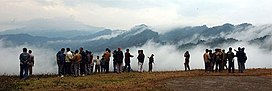
Shillong is a hill station and the capital of Meghalaya, a state in northeastern India. It is the headquarters of the East Khasi Hills district. Shillong is the 330th most populous city in India with a population of 143,229 according to the 2011 census. It is said that the rolling hills around the town reminded the British of Scotland. Hence, they would refer to it as the "Scotland of the East".

The Khasi people are an ethnic group of Meghalaya in north-eastern India with a significant population in the bordering state of Assam, and in certain parts of Bangladesh. Khasi people form the majority of the population of the eastern part of Meghalaya, that is Khasi Hills, constituting 78.3% of the region's population, and is the state's largest community, with around 48% of the population of Meghalaya. They are among the few Austroasiatic-speaking peoples in South Asia. The Khasi tribe holds the distinction of being one of the few remaining tribes that have a matrilineal society. Under the Constitution of India, the Khasis have been granted the status of Scheduled Tribe.

The Ledo Road was an overland connection between British India and China, built during World War II to enable the Western Allies to deliver supplies to China and aid the war effort against Japan. After the Japanese cut off the Burma Road in 1942 an alternative was required, hence the construction of the Ledo Road. It was renamed the Stilwell Road, after General Joseph Stilwell of the U.S. Army, in early 1945 at the suggestion of Chiang Kai-shek. It passes through the Burmese towns of Shingbwiyang, Myitkyina and Bhamo in Kachin state. Of the 1,726 kilometres (1,072 mi) long road, 1,033 kilometres (642 mi) are in Burma and 632 kilometres (393 mi) in China with the remainder 61 km was in India. The road had the Ledo-Pangsau Pass-Tanai (Danai)-Myitkyina--Bhamo-Mansi-Namhkam-Kunming route.

The Garo Hills are part of the Garo-Khasi range in Meghalaya state of India. They are inhabited by the Garo people. It is one of the wettest places in the world. The range is part of the Meghalaya subtropical forests ecoregion.

The Khasi Hills are a low mountain formation on the Shillong Plateau in the Meghalaya state of India. The Khasi Hills are part of the Garo-Khasi-Jaintia range and connect with the Purvanchal Range and the larger Patkai Range further east. The Khasi Hills, and the whole Garo-Khasi-Jaintia range, are in the Meghalaya subtropical forests ecoregion.

Pangsau Pass or Pan Saung Pass, 3,727 feet (1,136 m) in altitude, lies on the crest of the Patkai Hills on the India–Myanmar border. The pass offers one of the easiest routes into Burma from the Assam plains. The pass lies on the famous Ledo Road and named after the closest village on Myanmar's territory, Pangsau, which lies 2 km east of the pass. India's undisputed easternmost point "Chaukan Pass" - east of Vijaynagar in the Changlang district - lies northeast of Pangsau Pass.

The Chin Hills are a range of mountains in Chin State, northwestern Burma (Myanmar), that extends northward into India's Manipur state.

The Arakan Mountains, natively referred as Rakhine Yoma and technically known as the Southern Indo-Burman Range, are a mountain range in western Myanmar, between the coast of Rakhine State and the Central Myanmar Basin, in which flows the Irrawaddy River. It is the most prominent of a series of parallel ridges that arc through Assam, Nagaland, Manipur, Mizoram and Myanmar.

The People of Assam inhabit a multi-ethnic, multi-linguistic and multi-religious society. They speak languages that belong to four main language groups: Tibeto-Burman, Indo-Aryan, Tai-Kadai, and Austroasiatic. The large number of ethnic and linguistic groups, the population composition, and the peopling process in the state has led to it being called an "India in miniature".
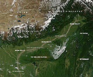
This article discusses the geological origin, geomorphic characteristics, and climate of the northeastern Indian state of Assam. Extending from 89° 42′ E to 96° E longitude and 24° 8′ N to 28° 2′ N latitude, it has an area of 78,438 km2, similar to that of Ireland or Austria.
The Dihing Patkai Festival is an annual festival held at Lekhapani in Tinsukia district of Assam. The festival is named after the majestic Patkai range and the mischievous Dihing River. It is organized by the Government of Assam, providing the tourists with boundless chances for fun and feast.
Nampong is a census town of Changlang District in the Indian state of Arunachal Pradesh. It is located close to the Pangsau Pass, being the last town on the Indian side, at an elevation of 308 metres. Nampong is one of the 60 constituencies of Arunachal. Name of current MLA (August-2016) of Nampong constituency is Laisam Simai.

Northeast India consists of eight states: Arunachal Pradesh, Assam, Manipur, Meghalaya, Mizoram, Nagaland, Sikkim and Tripura. Tourism in this area is based around the unique Himalayan landscape and culture distinct from the rest of India.

The Republic of India shares borders with several sovereign countries; it shares land borders with China, Bhutan, Nepal, Pakistan, Bangladesh, and Myanmar. Bangladesh, Myanmar, and Pakistan share both land borders as well as maritime borders, while Sri Lanka shares only a maritime border through Ram Setu. India's Andaman and Nicobar Islands share a maritime border with Thailand, Myanmar, and Indonesia.
The hill tribes of Northeast India are hill people, mostly classified as Scheduled Tribes (STs), who live in the Northeast India region. This region has the largest proportion of scheduled tribes in the country.

The Emblem of Meghalaya is the symbol used to represent the government of the state of Meghalaya, India.
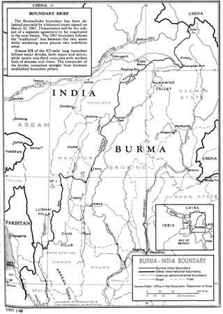
The India–Myanmar border is the international border between India and Myanmar. The border is 1,643 kilometres (1,021 mi) in length and runs from the tripoint with China in the north to the tripoint with Bangladesh in the south.