The Eastern Ghats are a discontinuous range of mountains along India's eastern coast. The Eastern Ghats pass through the states of Odisha and Andhra Pradesh to Tamil Nadu by, passing parts of Karnataka and Telangana on the way. They are eroded and cut through by four major rivers of peninsular India, namely, the Mahanadi, Godavari, Krishna and. Zindagad Konda is the highest point in both Andhra Pradesh and the Eastern Ghats at 1,690 metres (5,540 ft). The Biligiriranga Hills in Karnataka are the tallest hill range in the Eastern Ghats, with many peaks above 1500 m in height.

Yercaud, also spelt Erkad, is a town and hill station in Salem District in Tamil Nadu, India. Located in Servarayan Hills in the Eastern Ghats, it is situated at an altitude of 1,515 m (4,970 ft).
The Nilgiri Biosphere Reserve is a biosphere reserve in the Nilgiri Mountains of the Western Ghats in South India. It is the largest protected forest area in India, spreading across Tamil Nadu, Karnataka and Kerala. It includes the protected areas Mudumalai National Park, Mukurthi National Park, Sathyamangalam Wildlife Sanctuary in Tamil Nadu; Nagarhole National Park, Bandipur National Park, both in Karnataka; Silent Valley National Park, Aralam Wildlife Sanctuary, Wayanad Wildlife Sanctuary, and Karimpuzha Wildlife Sanctuary in Kerala.
Anaimalai Tiger Reserve, earlier known as Indira Gandhi Wildlife Sanctuary and National Park and as Anaimalai Wildlife Sanctuary, is a protected area in the Anaimalai Hills of Pollachi and Valparai taluks of Coimbatore District and Udumalaipettai taluk in Tiruppur District, Tamil Nadu, India. The Tamil Nadu Environment and Forests Department by a notification dated 27 June 2007, declared an extent of 958.59 km2 that encompassed the erstwhile IGWLS&NP or Anaimalai Wildlife Sanctuary, as Anaimalai Tiger Reserve under the Wildlife Protection Act, 1972. According to the National Tiger Conservation Authority, the Reserve presently includes a core area of 958.59 km2 and buffer/peripheral area of 521.28 km2 forming a total area of 1479.87 km2.

Monilesaurus rouxii, commonly known as Roux's forest lizard, Roux's forest calotes, or the forest blood sucker, is a species of arboreal, diurnal, agamid lizard, which is endemic to hills of peninsular India. In July 2018, it was proposed that the species should be transferred to the new genus Monilesaurus.

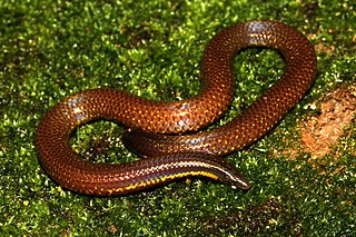
The collared cat snake is a species of nocturnal, tree-dwelling, rear-fanged colubrid snake endemic to southwestern India.

Beddome's coral snake is a species of venomous snake in the family Elapidae. The species is endemic to hills of peninsular India.
Uropeltis dindigalensis, commonly known as the Dindigul uropeltis and the Sirumalai Hills earth snake, is a species of snake in the family Uropeltidae. The species is endemic to Sirumalai and surrounding hill ranges of the southern Eastern Ghats, in Dindigul district of Tamil Nadu state in South India.
Uropeltis ellioti, commonly known as Elliot's earth snake and Elliot's shieldtail, is a species of snake in the family Uropeltidae. The species is endemic to India.

The yellow-throated bulbul is a species of songbird in the bulbul family of passerine birds. The species is endemic to southern peninsular India. They are found on scrub habitats on steep, rocky hills many of which are threatened by granite quarrying. It is confusable only with the white-browed bulbul with which its range overlaps but is distinctively yellow on the head and throat apart from the yellow vent. The calls of this species are very similar to that of the white-browed bulbul.

Koyna Wildlife Sanctuary is a wildlife sanctuary and natural World Heritage Site, which is located in Satara district of the Indian state of Maharashtra. Further, this wildlife sanctuary is designated as an Important Bird area. The sanctuary is nested in the Western Ghats, covering an area of around 423.55 km2 (163.53 sq mi), and elevations ranging from 600 to 1,100 m. It was notified in 1985 as a wildlife sanctuary situated in Maharashtra. It forms the northern portion of the Sahyadri Tiger Reserve, with Chandoli National Park forming the southern part of the reserve.

Kolli Malai also known as Kolli Hills, is a Hill station and Taluk in Namakkal district, in Tamil Nadu, India..
Meghamalai, commonly known as the High Wavy Mountains, is a mountain range located in the Western Ghats in the Theni district near Kumily, Tamil Nadu. It is dotted with cardamom plantations and tea plantations. The mountain range is 1,500 metres above sea level, and it is rich in flora and fauna. The area, now mostly planted with tea plants, includes cloudlands, high wavys, venniar, and the manalar estates belonging to the Woodbriar Group. Access is largely restricted and includes largely untouched remnants of evergreen forest.

The Grizzled Squirrel Wildlife Sanctuary (GSWS), also known as Srivilliputhur Wildlife Sanctuary, was established in 1988 to protect the Near threatened grizzled giant squirrel. Occupying an area of 485.2 km2, it is bordered on the southwest by the Periyar Tiger Reserve and is one of the best preserved forests south of the Palghat Gap.
Naduvalur is a village in the tehsil (taluk) of Gangavalli, which is located in the Salem district of the state of Tamil Nadu. The village is located in the central part of the southernmost state of India. Naduvalur is the largest village in the tehsil, and has the largest delegation to the Gangavalli Tehsil Council.
Bommidi is a panchayat town which is located in Pappireddipatti taluka of Dharmapuri district in Tamil Nadu, India. It is also known as B. Mallapuram. Bommidi's name is used for the railway station, the police station situated at Nadur, the post office, and bus transportation, while the name "B. Mallapuram" is used for schools, hospitals, and government officials.

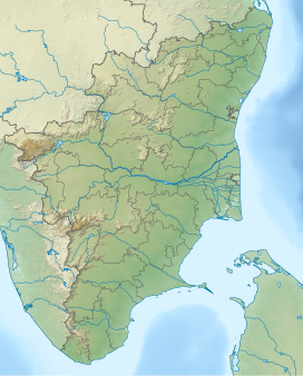
Sirumalai is a massif region of 60,000 acres (200 km2) situated 25 km (16 mi) from Dindigul, 90 km (56 mi) from Madurai, and 125 km from Trichy, Tamil Nadu, India. There are many high hills in the area. Sirumalai range is the last mountain range of the Eastern Ghats. The last mountains of the Sirumalai mountain range are the Azhagar Kovil Hills which are present in Madurai District. Azhagar Kovil Hills are the most important place of worship for the Hindu religion. Trekking is allowed in the Azhagar Kovil Hills. The nearest Eastern Ghats hills to Sirumalai Hills are the Narthamalai Hills.
Biogeographic classification of India is the division of India according to biogeographic characteristics. Biogeography is the study of the distribution of species (biology), organisms, and ecosystems in geographic space and through geological time. India has a rich heritage of natural diversity. India ranks fourth in Asia and tenth in the world amongst the top 17 mega-diverse countries in the world. India harbours nearly 11% of the world's floral diversity comprising over 17500 documented flowering plants, 6200 endemic species, 7500 medicinal plants and 246 globally threatened species in only 2.4% of world's land area. India is also home to four biodiversity hotspots—Andaman & Nicobar Islands, Eastern Himalaya, Indo-Burma region, and the Western Ghats. Hence the importance of biogeographical study of India's natural heritage.

Uropeltis shorttii, also known commonly as the Shevaroy Hills earth snake and Shortt's shieldtail snake, is a species of non-venomous snake in the family Uropeltidae. The species is endemic to the southern Eastern Ghats of India. This species was first described as Silybura shorttii by British naturalist Richard Henry Beddome in 1863. It is found only in the Shevaroy Hills of Salem district in Tamil Nadu state in South India. For a long time, this species was misclassified into Uropeltis ceylanica, a snake endemic to the Western Ghats, till a recent taxonomic study proved it to be a distinct species with a very narrow geographic range. It is a burrowing snake, presumed to be nocturnal, feeding on soft-bodied worms. It becomes active during the rains. U. shorttii has most recently been assessed for The IUCN Red List of Threatened Species in 2019, and is listed as "Critically Endangered" under criteria B1ab(iii).

Uropeltis madurensis, also known commonly as the Madura earth snake and the Madurai shieldtail, is an endangered species of small, fossorial, nonvenomous snake of the family Uropeltidae. The species is endemic to the Western Ghats of South India.