
India is situated north of the equator between 8°4' north to 37°6' north latitude and 68°7' east to 97°25' east longitude. It is the seventh-largest country in the world, with a total area of 3,287,263 square kilometres (1,269,219 sq mi). India measures 3,214 km (1,997 mi) from north to south and 2,933 km (1,822 mi) from east to west. It has a land frontier of 15,200 km (9,445 mi) and a coastline of 7,516.6 km (4,671 mi).

Chittoor is a city and district headquarters in Chittoor district of the Indian state of Andhra Pradesh. It is also the mandal and divisional headquarters of Chittoor mandal and Chittoor revenue division respectively. The city has a population of 153,756 and that of the agglomeration is 175,647.

The large Deccan Plateau in southern India is located between the Western Ghats and the Eastern Ghats, and is loosely defined as the peninsular region between these ranges that is south of the Narmada River. To the north, it is bounded by the Satpura and Vindhya Ranges.

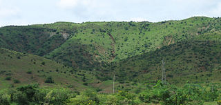
The Eastern Ghats are a discontinuous range of mountains along India's eastern coast. The Eastern Ghats pass through the states of Odisha and Andhra Pradesh to Tamil Nadu by, passing parts of Karnataka and Telangana on the way. They are eroded and cut through by four major rivers of peninsular India, viz., the Mahanadi, Godavari, Krishna and Kaveri. Sitamma Konda is the highest point in both Andhra Pradesh and the Eastern Ghats at 1,680 metres (5,510 ft). The Biligiriranga Hills in Karnataka are the tallest hill range in the Eastern Ghats, with many peaks above 1500 m in height.
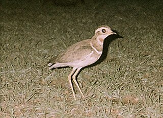
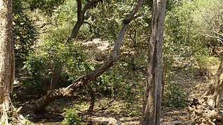
Jerdon's courser is a nocturnal bird belonging to the pratincole and courser family Glareolidae endemic to India. The bird was discovered by the surgeon-naturalist Thomas C. Jerdon in 1848 but not seen again until its rediscovery in 1986. This courser is a restricted-range endemic found locally in India in the Eastern Ghats of Andhra Pradesh. It is currently known only from the Sri Lankamalleswara Wildlife Sanctuary, where it inhabits sparse scrub forest with patches of bare ground.

Rayalaseema is a geographic region in the Indian state of Andhra Pradesh. It comprises four southern districts of the State, from prior to the districts reorganisation in 2022, namely Kurnool, Anantapur, YSR and Chittoor. Four new districts were created from these, namely Sri Sathya Sai, Nandyal, Annamayya and Tirupati. As of 2011 census of India, the western four districts of the region had a population of 15,184,908 and cover an area of 71,060 km2 (27,440 sq mi).

Penna is a river of southern India. This is a unique river in world where after originating from Nandi hills, it flows as two different streams, one in North and South directions. The Penna rises in the Nandi Hills in Chikkaballapur District of Karnataka state, and runs north and east through the states of Karnataka and Andhra Pradesh to empty into bay of bengal in Andhra Pradesh. It is 597 kilometres (371 mi) long, with a drainage basin covering 55,213 km2: 6,937 km2 in Karnataka and 48,276 km2 in Andhra Pradesh. Along with this main stream there is another stream south towards Tamilnadu with the name Then Pennai or south Pennar which further moves towards the east to empty into the Bay of Bengal.The Penna river basin lies in the rain shadow region of Eastern Ghats and receives 500 mm average rainfall annually.
The Erramala are a range of low hills in southern India, in Kurnool district of Andhra Pradesh state. The Erramala hills lie on the Deccan plateau, running east–west and dividing the basin of the Penna River to the south from the basin of the Krishna River to the north. The hill range may be extended along the Penna River basin in Kadapa district.

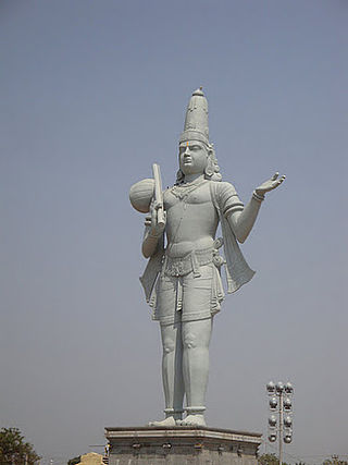
Tirupati is a city in the Indian state of Andhra Pradesh. It is the administrative headquarters of the Tirupati district. The city is home to the important Hindu shrine of Tirumala Venkateshwara Temple and other historic temples. It is located at a distance of 150 km from Chennai, 250 km from Bangalore,406 km from Amaravati. It is one of the eight Svayam vyakta kshetras dedicated to Vishnu. Tirupati is a municipal corporation and the headquarters of Tirupati (urban) mandal, Tirupati (rural) mandal, and the Tirupati revenue division.

Chittoor district is one of the eight districts in the Rayalaseema region of the Indian state of Andhra Pradesh. It has a population of 18,72,951 according to 2011 census of India. It is a major market centre for mangoes, grains, sugarcane, and peanuts. The district headquarters is located at Chittoor.

Kadapa district is one of the twenty six districts in the Indian state of Andhra Pradesh. In 2022 reorganisation of Andhra Pradesh districts, the district boundary is largely restricted to Kadapa parliamentary constituency area. It is also one of the eight districts in the Rayalaseema region. Kadapa is the administrative headquarters for this district.

Nellore district, officially known as Sri Potti Sriramulu Nellore district in Coastal Andhra Region, is one of the 26 districts in the Indian state of Andhra Pradesh. According to the 2011 Census, the district's population was 2,469,712 of which 29.07% was urban. Its administrative headquarters are located in Nellore city. Located in the Coastal Andhra region, the district is bordered by the Bay of Bengal to the east, Kadapa district and Annamayya district to the west, Prakasam district to the north, and Tirupati district to the south.
Rajampeta is a Municipality in Annamayya district of the Indian state of Andhra Pradesh, located in the Rayalaseema Region formed on the banks of Cheyyeru River. The town has an average elevation of 139 meters (456 ft). Rajampet is a Grade II Municipality which upgraded in 2019 and has an area of 35.38 square kilometres (13.66 sq mi). It consists of 29 election wards.

Kadapa is a city in the southern part of Andhra Pradesh, India. It is located in the Rayalaseema region, and is the district headquarters of YSR Kadapa district. As of the 2022 Census of India, the city had a population of 466,000, a 2.42% increase from 2021. It is located 8 kilometres (5.0 mi) south of the Penna River. The city is surrounded on three sides by the Nallamala and Palkonda Hills lying on the tectonic landscape between the Eastern and Western ghats. Black and Red ferrous soils occupy the region. The city is nicknamed "Gadapa" ('threshold') since it is the gateway from the west to the hills of Tirumala.
Seshachalam Hills are hilly ranges part of the Eastern Ghats in southern Andhra Pradesh state, in southeastern India. The Seshachalam hill ranges are predominantly present in Annamayya and Tirupati Districts of the Rayalaseema region in Andhra Pradesh, India.
The Central Deccan Plateau dry deciduous forests in Western and Southern India, containing large protected areas of natural tiger habitat.

Andhra Pradesh lies between 12°41' and 19.07°N latitude and 77° and 84°40'E longitude, and is bordered by Telangana to the north and west, Chhattisgarh to the north-west, Orissa to the north, the Bay of Bengal to the east, Tamil Nadu to the south and Karnataka to the southwest and west. Andhra Pradesh has a coastline of around 974 km, which gives it the second longest coastline in the nation. Two major rivers, the Godavari and the Krishna run across the state. A small enclave 12 sq mi (30 km²), the Yanam district of Puducherry, lies in the Godavari Delta in the north east of the state. The state includes the eastern part of Deccan plateau as well as a considerable part of the Eastern Ghats.
National Highway 716 is a National Highway in India. It starts from its junction with NH 16 near Chennai in Tamil Nadu and terminates at its junction with NH 40 near Kadapa in Andhra Pradesh.
Sagileru is a river in the southern Indian state of Andhra Pradesh that is a tributary of the Pennar.
Annamayya district is one of the eight districts in the Rayalaseema region of Andhra Pradesh, established in 2022. Rayachoti is the district administrative headquarters and Madanapalle is the most populated City in the district.


